
Passengers 11 Injuries (non-fatal) 0 Total fatalities 19 (all) Passenger count 11 | Crew 8 Survivors 0 Date 29 October 1953 Survivor 0 | |
 | ||
Similar 1953 Nutts Corner BEA Vick, Transocean Air Lines Flight 512, National Airlines Flight 470, Air France Flight 178, 1953 Skyways Avro York | ||
Bcpa flight 304 top 6 facts
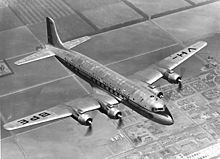
British Commonwealth Pacific Airlines (BCPA) Flight 304/44 was the scheduled flight from Sydney, to Vancouver, British Columbia in Canada, with scheduled stops at Nadi (pronounced Nandi) (Fiji), Canton Island, Honolulu and San Francisco. On 29 October 1953 the flight was conducted by the Douglas DC-6 named Resolution and registered in Australia as VH-BPE. It crashed during its initial approach towards San Francisco International Airport, killing all 19 people on board, including the American pianist William Kapell.
Contents
- Bcpa flight 304 top 6 facts
- Events leading up to crash
- Aftermath
- Investigation
- Resolution Trail
- References
The aircraft was flying the Honolulu – San Francisco leg with a crew of 8 and 11 passengers (10 adults and 1 child). The estimated flying time was 9 hours and 25 minutes. Captain Bruce N. Dickson (aged 34) and his crew took over the plane in Honolulu as scheduled.
Dickson and his First Officer, Frank A. Campbell (aged 28), each had several thousand hours of flight time in the DC-6. Both pilots had made more than 100 approaches into San Francisco Airport, many of which were instrument approaches. On 29 October the weather in the San Francisco area did not present adverse flight conditions, but visual reference with the ground was precluded by the overcast foggy conditions so an instrument approach was required.
Events leading up to crash
As the flight neared the California coast, the crew contacted San Francisco Air Route Traffic Control (ARTC). At 8:07 am Pacific Standard Time, it was cleared to descend in accordance with Visual Flight Rules and to maintain at least 500 feet (150 m) on top of clouds, which the crew acknowledged.
At 8:15 am, the flight reported that it was starting descent and at that time was given the San Francisco weather report. Just after 8:21 am ARTC cleared the flight to the San Francisco Instrument Landing System (ILS) Outer Marker beacon via the Half Moon Bay Fan Marker direct to the San Francisco Outer Marker, with instructions to maintain at least 500 feet (150 m) above all clouds and to contact San Francisco Approach Control after passing the Half Moon Bay Fan Marker.
At 8:39 am, the crew called San Francisco Approach Control and advised that it was over Half Moon Bay, 500 feet (150 m) on top of clouds. Approximately three minutes later, the crew reported "Southeast, turning inbound". At 8:45 am, a call to the flight was unanswered as were all subsequent calls.
George Bordi, a local resident of the day who heard the plane fly overhead, in thick fog, then moments later heard the tremendous "crump" sound of the plane impacting on nearby terrain.
William Kapell, 31 years old, a New York pianist who was returning from a concert tour in Australia, was among the eleven passengers and eight crewmen losing their lives. Kapell was the only United States citizen in the plane. Most of the others were from Australia, the United Kingdom along with one passenger from Canada.
Aftermath
Many hours after the crash, members of search parties, who had difficulty getting through a dense wood at the base of King's Mountain, said that they could find no survivors.
Red Cross volunteers and emergency personnel, including what would become the first forensic investigation team in the United States, recovered bodies and wreckage, used dental records to ID remains, and put out three forest fires started by the crash. The Redwood City Armory was used by the sheriff's department as a makeshift morgue. Except for the body of William Kapell, which was quickly transported by family members back to his home state of New York, bodies were cremated at Cypress Lawn Cemetery in Colma, California and returned to their families. Two (2) did remain in the cemetery, passenger Williaam (two "a"s is the correct spelling) Cox in a standard plot, while purser Knight's ashes were placed in a niche in the columbarium at Cypress Lawn.
Investigation
The Civil Aeronautics Board investigated the accident. The investigation began immediately after the wreckage was located in the mountainous area southwest of San Francisco, about seven and a half miles southeast of the town of Half Moon Bay. The aircraft was almost entirely destroyed by impact and ensuing fire. It had initially topped several large redwood trees, shearing off one of its landing gear and leaving it hung in an oak, continued across a narrow ravine and crashed against the side of a steeply rising slope approximately half a mile beyond the first tree strike. The main wreckage area was at about 1,950 feet (590 m) above sea level.
The landing gear was down and locked at impact. There was no evidence of mechanical or structural failure prior to the impact.
The accident site was between the Half Moon Bay Fan Marker and the ILS Outer Marker and it appears that the flight had not maintained at least 500 feet (150 m) on top of clouds between these points but had descended in weather conditions which precluded reference to the ground.
In addition, the flight had reported being over the Half Moon Bay Fan Marker at 8:39 am and then "Southeast, turning inbound" at about 8:42 am. In this time interval it would not have been possible for the flight at normal speed to have flown from the Half Moon Bay Outer Marker to the ILS Outer Marker, make the required turn and return to the site of the crash in accordance with Civil Aeronautics Authority approved instrument approach procedure. Thus it was likely that when the pilot reported he was "Southeast, turning inbound", he was in fact southwest of the airport.
The investigation then stated it was probable that the captain, after reporting he was over Half Moon Bay, either saw the terrain momentarily through an unreported break in the overcast foggy conditions or because of a radio navigational error became convinced that his position was farther northeast and started to descend over what he believed was the proper area.
It was therefore concluded that the probable cause of the crash was the failure of the crew to follow prescribed procedures for an instrument approach.
Resolution Trail
Today, the crash site is part of the El Corte de Madera Creek Open Space Preserve, which includes the "Resolution Trail", named for the plane. Park rules restrict visitors to the trail and visitors are also requested to respect this historical site by leaving any artefacts where they find them.
Over fifty people attended a plaque's dedication on 27 June 2009, near the junction of the Fir & Vista Point trails, just below the park's Vista Point, where a military H-19 'Chickasaw' recovery helicopter landed on the day of the crash.