
Basin size 1,304 km (503 sq mi) Discharge 10.8 m³/s | Length 103 km | |
 | ||
Main source Picardie131 m (430 ft) | ||
The Authie is a river in northern France whose 103-kilometre (64 mi) course crosses the departement of the Pas-de-Calais and the Somme. Its source is near the village of Coigneux. It flows through the towns of Doullens, Auxi-le-Château, Nempont-Saint-Firmin and Nampont, finally flowing out into the Channel near Berck.
Contents
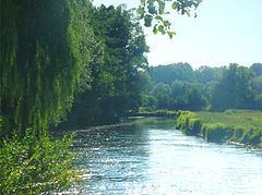
- Map of LAuthie Auxi le ChC3A2teau France
- EtymologyEdit
- HydrologyEdit
- Departements and communes traversedEdit
- BibliographyEdit
- References
Map of L'Authie, Auxi-le-Ch%C3%A2teau, France
Its regular course has attracted mankind for many centuries, developing an agricultural environment that is still dominant today. The valley of the Authie, with many towns, villages, abbeys and chateaux, holds a rich architectural heritage alongside the banks of the river, while the river mouth forms a sizeable bay between Fort-Mahon-Plage and Berck, typical of Picardy estuaries. The area is home to a diverse range of flora and fauna.
EtymologyEdit
The origin of the name Authie has not been established with any certainty. A possibility is the pre-Celtic word atur meaning river. Many waterways’ names, such as the Adour, are a corruption of the Celtic term alt meaning deep and that could refer to the steep-sided bed of the river. Another suggestion stems from the Latin word attegia designating groups of fishermen and lumberjacks living by any river. .
HydrologyEdit
In the context of an oceanic/pluvial system, the Authie has a uniform and comparatively sustained outflow of 10.8 cubic metres per second (380 cu ft/s) at its outlet. The river flow is affected by the oceanic climate, characterized by an average annual temperature of 10 °C (50 °F), very few days of frost, comparatively high rainfall between 800 and 900 mm (31 and 35 in) per year except near the coast estuary where rainfall is less than 650 mm (25.6 in) per year.