
Area 47.12 km² | Canton Mauléon-Licharre Population (2010) 251 | |
 | ||
Aussurucq (Basque: Altzürükü) is a French commune in the Pyrénées-Atlantiques department in the Nouvelle-Aquitaine region of south-western France.
Contents
- Map of 64130 Aussurucq France
- Geography
- Toponymy
- History
- Administration
- Inter communality
- Demography
- Economy
- Culture and Heritage
- Civil heritage
- Religious heritage
- Environmental heritage
- Amenities
- Notable people linked to the commune
- References
Map of 64130 Aussurucq, France
The inhabitants are known as Altzürükütar.
Geography
Aussurucq is located in the former province of Soule in the Massif des Arbailles some 30 km west by south-west of Oloron-Sainte-Marie and 25 km east of Saint-Jean-Pied-de-Port. Access to the commune is by road D147 from Idaux-Mendy in the north which passes through the village and continues south through the commune to join the D117 on the southern border of the commune. A pastoral road from Béhorléguy to Alçay and Aussurucq passes through the Col d'Aphanize (without crossing it) and generally follows the line of the watershed along the Col de Burdin Olatzé. The commune is mostly rugged and heavily forested however there is some farmland in the north.
The Ruisseau de Guessalia rises in the south of the commune and flows north-east gathering some tributaries to join the Apouhoura north of the commune. The Arangorena forms the north-western border as it flows north-east to join the Saison near Gotein-Libarrenx. The Bidouze rises in the south of the commune and flows north to eventually join the Adour north of Bardos.
Toponymy
The commune name in basque is Altzürükü.
Jean-Baptiste Orpustan indicated that the name comes from the basque altzu ("alder tree") which is explained by the position of the valley covered in alder trees. The second part of the name is more enigmatic. According to Orpustan it could be from Urru ("the other side") or iri giving alzu-(i) ri-ku meaning "place in the Alder field".
The following table details the origins of the commune name and other names in the commune.
Sources:
Origins:
History
In the Middle Palaeolithic era Soule was already populated as remains of Neanderthal prehistoric man have been found in the Xaxixiloaga caves in Aussurucq. A tumulus was also reported at shepherd's cabins in Potxo along the D147 road.
The central part of Soule is also called the Messagerie des Arbailles between Basabürü and Pettarra (in the Sauguis-Saint-Étienne, Aussurucq, and Barcus regions).
Administration
List of Successive Mayors
(Not all data is known)
Inter-communality
The commune is part of six inter-communal structures:
Demography
In 2010 the commune had 251 inhabitants. The evolution of the number of inhabitants is known from the population censuses conducted in the commune since 1793. From the 21st century, a census of communes with fewer than 10,000 inhabitants is held every five years, unlike larger towns that have a sample survey every year.
Sources : Ldh/EHESS/Cassini until 1962, INSEE database from 1968 (population without double counting and municipal population from 2006)
Economy
Economic activity is based on agriculture (livestock and pasture). The commune is part of the Appellation d'origine contrôlée (AOC) zone of Ossau-iraty.
Culture and Heritage
The village features a dynamic scene related especially to Basque culture. The inhabitants of the village performed the pastoral Ürrüti Jauregiko Peirot in 2002, a play written by the son of the village Niko Etxart, an acclaimed Basque musician.
Civil heritage
Religious heritage
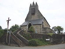
The town has a church with a Trinitarian steeple or a tower surmounted by three points of nearly equal height. The church contains a processional cross (17th century) which is registered as an historical object.
Environmental heritage
At the end of the 19th century, the Arbailles Forest covered parts of the communes of Aussurucq, Béhorléguy, Camou-Cihigue, Musculdy, Ordiarp, and Saint-Just-Ibarre.
A wealth of heritage in Aussurucq commune is contained in its sub-soil. Most of the territory of the commune is karstic. The environment is characterized by the presence of natural cavities in complex shapes that have not all yet been discovered or much less explored to date. Departmental cavers have undertaken the exploration, description, and publication of this heritage respecting the environment and the local population. One of the most beautiful caves in the commune is the Nébélé which has been the subject of works and regular explorations since 1972.
The peak of Ascune stands at 860 m, Echagorry is 935 m, Elsarré is 1,153 m, Sihigue is 1,193 m, and Etchecortia is 1,204 m. In the south-west of the commune, Bohorcortia is 1,214 metres high.
Amenities
The town has a primary school (Garaibie).