
Country France Population (2006) 1,155 Local time Thursday 12:19 AM | Canton Navarrenx(chef-lieu) Area 6.21 km² | |
 | ||
Intercommunality Communauté de communes du canton de Navarrenx Weather 6°C, Wind SE at 5 km/h, 91% Humidity | ||
Navarrenx is a commune in the department of Pyrénées-Atlantiques ( Béarn ) and the region Nouvelle-Aquitaine. The gentilé is Navarre. Since 2014, the town was called to join the association Les Plus Beaux Villages de France.
Contents
Map of 64190 Navarrenx, France
Etymology
The name Navarrenx comes from sponda Navarrensi, meaning the "bedstead of Navarre." According linguist Michel Grosclaude it may have meant the edge of the Navarre. There may be kinship between the Basque radical Navarre and Navarrenx, but Basque philologists hesitate to link the several etymologies.
History
The earliest history of the site date to the first century. Navarrenx is reported in a cartulary of the eleventh century under the name of Sponda-Navarrensis.
In 1188, Gaston VI (Gaston VI, Viscount of Béarn) called for a charter of a "Bridge of Navarrenx" a stone bridge, and the establishment of a market, and a perimeter "sauveté" (a sauveté is in the south of France in the Middle Ages, an area of extraterritoriality, protected by the Catholic Church and in which man's law no longer applies. This space of freedom, in the scope of which he was forbidden to pursue the fugitives, was marked by boundaries, with "hospitau" and chapel. The bridge was finally built in 1289. It facilitates access to Pyrenean passes and Navarra, particularly for pilgrims on the Way of Saint Jacques de Compostela. Indeed, the village is an important step on the road to Puy crossroads leading to the Somport pass to the east and to the west of Roncesvalles.
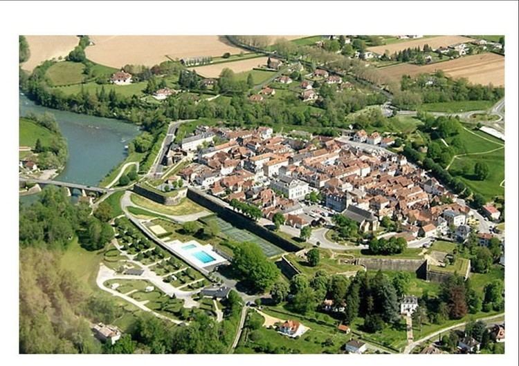
The Viscount of Béarn built a magnificent castle Casterasse ("fortress") on the hill to the west, at the confluence of the Gave d’Oloron and L’Arroder Rivers. In 1523 the Castilian's led by Philibert of Chalon, Prince of Orange, seized the city and destroy Casterasse. Henri II d'Albret, the king of Navarre, decided to reinforce defences on the right bank of the mountain stream of Oloron. From 1538 to 1546, fortification works were carried out under the direction of Béarn master builders François Girard and Arnaud de Mirassor, as per the design of Italian architectural engineer Fabricio Siciliano. Navarrenx was thus transformed into a modern fortified town "Italian-style", based on the citadel of Lucas in Tuscany. Later, a powder magazine would be built that would store up to 25000 pounds of gunpowder: a square-shaped construction little more than nine metres long, it was originally surrounded by a wall, part of which was visible aboveground. While this wall has since disappeared, the thickness of this wall (1.4m) and the lowness of the building (6m) prevented it from receiving direct hits from enemy forces.
The fortifications were tried and tested during religious wars under the reign of Jeanne of Albret, when the garrison under the command of the Baron of Arros successfully resisted a three-month siege in 1568. The town was re-equipped in the XVIII century, in particular with the Saint-Antoine gate built by engineer De Salmon on the ruins of an old church. Facing Spain, the gate owed its name to a chapel that welcomed pilgrims and was destroyed during the construction of the ramparts. With three massive arcades, the town was accessed via a drawbridge, the passage of the chains of which can still be seen today. In the XIX century, work on road and rail infrastructure led to the destruction of the old Saint-Germain gate which faced France.
Over the centuries, the fortified wall of Navarrenx has retained its main features. It outlines a reinforced firing range at each of its five corners with a bastion. Two of the five are fitted with anti-mine galleries, while a glacis and ground structures reinforce the town to the east, ahead of the moat. Several barracks have been built inside the walls to house the garrison, one of which nowadays is used as the tourist information office. From the top of the ramparts (for example, from the crenellation platform overhanging the Saint-Antoine gate), there is a pleasant view of the Pyrenees and, below, the arches of the bridge of Navarrenx (XIII century). Visits There is free access to the 1818-metre perimeter of the town. The walls of the city contain bilingual (French-English) descriptive plaques that trace the history of each structure. Information on guided visits can be obtained from the Navarrenx district tourist office.