
Country United States Elevation 268 m | Incorporated July 2, 1979 Population 29,096 (2013) | |
 | ||
Weather 11°C, Wind NW at 10 km/h, 72% Humidity Points of interest Charles Paddock Zoo, Atascadero Lake Park, Heilmann Regional Park, A‑Town Park | ||
Atascadero is a city in San Luis Obispo County, California, about equidistant from Los Angeles and San Francisco on U.S. Route 101. Atascadero is part of the San Luis Obispo - Atascadero - Paso Robles metropolitan area. Atascadero is farther inland than most other cities in the county, and as a result, usually experiences warmer, drier summers, and cooler winters than other nearby cities such as San Luis Obispo and Pismo Beach. The main freeway through town is the US 101. The nearby State Routes 41 and 46 provide access to the Pacific Coast and the California Central Valley.
Contents
- Map of Atascadero CA 93422 USA
- History
- Geography
- Climate
- 2010
- 2000
- Downtown
- Government
- Annual events
- Freeways and highways
- Rail transportation
- Airports
- Education
- Elementary schools
- Middle schools
- High schools
- Colleges
- Sports and recreation
- Parks
- Atascadero City Hall
- Atascadero Fire Department
- Atascadero Police Department
- Atascadero Public Library
- Colony Park Community Center
- Paramedic and ambulance services
- Ranger House
- In popular culture
- References
Map of Atascadero, CA 93422, USA
Founded by E.G. Lewis in 1913, the city grew to 29,096 people as of 2013.
History
Atascadero is a Spanish word loosely translated as bog, from the verb "atascar" which means to become stuck or hindered. Also, in the Chumash language, Atascadero translates into a place of much water.
The area was originally home to the Salinan Indians. In the half century between 1769 and 1823 the Spanish Franciscans established 21 missions along the California coast, including the nearby Mission San Miguel Arcángel, and Mission San Luis Obispo de Tolosa. In 1821, Mexico won its independence from Spain, and California became a Mexican province. In 1833, the Mexican government secularized the mission lands. Mexican Governor Juan Alvarado granted Rancho Atascadero to Trifon Garcia in 1842, and Pio Pico granted Pedro Estrada Rancho Asuncion in 1845. Patrick Washington Murphy held ownership of 61,000 acres (25,000 ha) at one time.
Edward Gardner Lewis, a magazine publisher from the East, founded Atascadero in 1913 as a utopian, planned colony. He had previously created such a community, at University City, Missouri. After purchasing the Atascadero Ranch in 1912, Lewis put together a group of investors, paid J.H. Henry $37.50 per acre ($93/ha), and celebrated acquisition of the ranch on July 4, 1913. As investors came to homestead the land that they had bought with their down payments, the area was transformed into a "tent city" with tents situated on land now occupied by Century Plaza and Bank of America. Lewis employed the services of experts in agriculture, engineering and city planning to develop his dream colony for the anticipated 30,000 residents. In 1914 the land was surveyed and subdivided. Thousands of acres of orchards were planted, a water system was installed, and construction began on an 18 mi (29 km) road (now Highway 41 west) through the Santa Lucia Mountains to the ocean (Morro Bay), where Lewis built cottages and a beachfront hotel called the Cloisters.
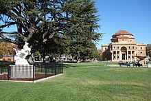
The first civic building in Atascadero, The Printery, had the first rotogravure presses west of Chicago. Lewis then published the Atascadero News newspaper and the Illustrated Review, a photo/news magazine. The centerpiece of Lewis' planned community was an Italian Renaissance-style building, which was the home to Atascadero City Hall and the Museum until it was damaged in the 2003 earthquake. After significant upgrades and renovations, the building was re-opened in August, 2013. Built between 1914 and 1918 with bricks made from local clay, this unique and beautiful building has become one of California's Historical Landmarks (No. 958).
Founded in 1913 by Edward Gardner Lewis and incorporated in 1979, the Atascadero Colony as it was known at the time was originally envisioned as a model community. Little evidence of Atascadero's original architecture and urban design remain, as historic buildings and homes have been torn down to make way for more modern developments and the Sunken Gardens bisected by U.S. Route 101. One of the few surviving examples of original urban design can be found, however, in the Rotunda Building located near the Junior High School on Palma Avenue in the Sunken Gardens public park. Designed by Walter D. Bliss of San Francisco, construction was completed in 1918 at a cost of $180,000. It was the headquarters for the Atascadero Colony, built of reinforced concrete and locally produced brick, it had also served as a private school for boys, a veteran's memorial building, and county offices. Location: 6500 Palma Ave, Atascadero. This building was purchased by San Luis Obispo County in the 1950s as a Memorial Building. The building housed the county library, Atascadero Historical Social Museum and then the city offices following incorporation in 1979. The historic City Hall is adorned with a 40 ft (12 m) dome atop the third story, originally intended to house the library. The building was designated a California Historical Landmark. The City Hall was damaged by the magnitude 6.5 San Simeon earthquake on the morning of December 22, 2003.
Another example of Atascadero's early architecture is The Carlton Hotel, built in 1929, located just west of the Sunken Gardens on El Camino Real, the city's main commercial street. Vacant since 1987, the building was rejuvenated, costing an estimated $15 million and completed in 2003.
The Skytherm house was developed in Atascadero. This private home pioneered solar powered cooling and heating using an integrated rooftop water system. Solar roof ponds are unique solar heating and cooling systems developed by Harold Hay in the 1960s. A basic system consists of a roof-mounted water bladder with a movable insulating cover. This system can control heat exchange between interior and exterior environments by covering and uncovering the bladder between night and day. When heating is a concern the bladder is uncovered during the day allowing sunlight to warm the water bladder and store heat for evening use. When cooling is a concern the covered bladder draws heat from the building's interior during the day and is uncovered at night to radiate heat to the cooler atmosphere. The Skytherm house in Atascadero, California uses a prototype roof pond for heating and cooling.
Atascadero is nearby the Carrizo Plain, a center for large scale photovoltaic solar energy projects that are planned to reach the gigawatt scale by 2012.
Geography
According to the United States Census Bureau, the city has a total area of 26.1 sq mi (68 km2), of which, 25.6 sq mi (66 km2) is land and 0.5 sq mi (1.3 km2) or 1.87 percent is water. Atascadero is geographically the largest city in San Luis Obispo County.
Climate
Atascadero experiences a hot semi-arid climate (Köppen climate classification BSh).
2010
The 2010 United States Census reported that Atascadero had a population of 28,310. The population density was 1,083.5 people per square mile (418.3/km²). The racial makeup of Atascadero was 24,457 (86.4%) White, 585 (2.1%) African American, 295 (1.0%) Native American, 685 (2.4%) Asian, 57 (0.2%) Pacific Islander, 1,205 (4.3%) from other races, and 1,026 (3.6%) from two or more races. Hispanic or Latino of any race were 4,429 persons (15.6%).
The Census reported that 26,986 people (95.3% of the population) lived in households, 224 (0.8%) lived in non-institutionalized group quarters, and 1,100 (3.9%) were institutionalized.
There were 10,737 households, out of which 3,428 (31.9%) had children under the age of 18 living in them, 5,681 (52.9%) were opposite-sex married couples living together, 1,185 (11.0%) had a female householder with no husband present, 538 (5.0%) had a male householder with no wife present. There were 661 (6.2%) unmarried opposite-sex partnerships, and 112 (1.0%) same-sex married couples or partnerships. 2,497 households (23.3%) were made up of individuals and 879 (8.2%) had someone living alone who was 65 years of age or older. The average household size was 2.51. There were 7,404 families (69.0% of all households); the average family size was 2.94.
The population was spread out with 6,068 people (21.4%) under the age of 18, 2,280 people (8.1%) aged 18 to 24, 7,244 people (25.6%) aged 25 to 44, 9,032 people (31.9%) aged 45 to 64, and 3,686 people (13.0%) who were 65 years of age or older. The median age was 41.0 years. For every 100 females there were 103.2 males. For every 100 females age 18 and over, there were 103.5 males.
There were 11,505 housing units at an average density of 440.3 per square mile (170.0/km²), of which 6,827 (63.6%) were owner-occupied, and 3,910 (36.4%) were occupied by renters. The homeowner vacancy rate was 2.2%; the rental vacancy rate was 5.8%. 17,470 people (61.7% of the population) lived in owner-occupied housing units and 9,516 people (33.6%) lived in rental housing units.
2000
According to the 2000 census, there were 26,411 people, 9,531 households, and 6,814 families residing in the city. The population density was 987.8 per square mile (381.4/km²). There were 9,848 housing units at an average density of 368.3 per square mile (142.2/km²). The racial makeup of the city was 88.79% White, 2.36% African American, 0.94% Native American, 1.27% Asian, 0.11% Pacific Islander, 3.19% from other races, and 3.34% from two or more races. Hispanic or Latino of any race were 10.54% of the population.
There were 9,531 households, of which 35.9% had children under the age of 18 living with them, 55.5% were married couples living together, 11.4% had a female householder with no husband present, and 28.5% were non-families. 22.0% of all households were made up of individuals and 8.1% had someone living alone who was 65 years of age or older. The average household size was 2.62 and the average family size was 3.05.
In the city, the population was spread out with 25.6% under the age of 18, 8.3% from 18 to 24, 28.8% from 25 to 44, 25.8% from 45 to 64, and 11.5% who were 65 years of age or older. The median age was 38 years. For every 100 females there were 106.2 males. For every 100 females age 18 and over, there were 105.4 males.
The median income for a household in the city was $48,725, and the median income for a family was $55,009. Males had a median income of $41,692 versus $29,740 for females. The per capita income for the city was $20,029. About 6.9% of families and 9.0% of the population were below the poverty line, including 10.7% of those under age 18 and 6.3% of those age 65 or over.
Downtown
Downtown Atascadero is home to First-Class Art galleries, restaurants, micro-breweries, wine bars and entertainment. There are many redevelopment projects underway and planned in downtown including the rebuilding of Colony Square (the downtown entertainment district).
Government
Atascadero is a general law city, governed by a city council. The council consists of five members, elected at-large: a mayor (who serves a two-year term) and four council members (who serve four-year terms).
In the California State Legislature, Atascadero is located in the 17th Senate District, represented by Democrat Bill Monning, and the 35th Assembly District, represented by Republican Jordan Cunningham.
In the United States House of Representatives, Atascadero is in California's 24th congressional district, represented by Democrat Salud Carbajal.
Annual events
Sweetheart Stroll - Downtown - Saturday before Valentine's Day - February
Wildflower Bike Ride - April
Central Coast Cinco de Mayo - Saturday before May 5
Atascadero Lakeside Wine Festival - Atascadero Lakeside Park - Saturday - June
Tuesday's in the Park Community BBQ - Atascadero Lakeside Park - June to August
Saturday in the Park Summer Concert Series - Atascadero Lakeside park - June to August
Ice Cream Zoofari at the Zoo - July
Movies in the Gardens at Sunken Gardens - August
Hot El Camino Cruise Night - Huge Car Cruise on Friday evening - August
Mid-State Cruizers Car Show - Atascadero Lakeside Park - Saturday - August
Colony Days Parade & Celebration - Downtown - Third Saturday in October
Halloween ZooBoo at the Zoo - October
Holiday Boutique at the Pavilion on the Lake - Third Saturday - November
Atascadero's Annual Holiday Lighting Ceremony - First Friday December
Downtown Winter Wonderland - Downtown - Second Friday in December
Zoo Holiday Magic at the Charles Paddock Zoo - Third Saturday December
More information: [www.visitatascadero.com]
Freeways and highways
Atascadero is at the major Ground Transport intersection of the Freeway U.S. 101 and the CA SR 41 exactly halfway between Los Angeles and San Francisco on the U.S. 101 with direct eastbound access to the San Joaquin Valley and Interstate 5 and the Yosemite Freeway. Atascadero is currently serviced by 1 Freeway and 1 Highway:
Rail transportation
Atascadero has a railway going right through it. Most commonly, the Amtrak passengers and Union Pacific freights go through.
Airports
Atascadero is close to San Luis Obispo's airport. San Luis Obispo County Regional Airport (IATA: SBP, ICAO: KSBP, FAA LID: SBP), also known as McChesney Field, is an airport located in San Luis Obispo, California serving San Luis Obispo County. The airport is mostly used for general aviation, but is also served by two commercial airlines. Located just south of the City of San Luis Obispo, the San Luis Obispo County Regional Airport serves areas as far north as Southern Monterey County and as far south as Northern Santa Barbara County. The airport offers convenient access to and from the Central Coast. Residents and visitors have the choice of two commercial airlines with flights to Los Angeles, Phoenix, San Francisco, and Portland, Oregon. The airport is also home to full service general aviation and corporate facilities.
Education
The Atascadero Unified School District is home to 6 Elementary Schools, 2 middle / Junior High Schools, 3 High Schools, 1 College, and 5+ miscellaneous school sites and programs.
Elementary schools
Middle schools
High schools
Colleges
Sports and recreation
Atascadero offers its residents and visitors cycling, hiking, golfing, tennis, swimming, and much more.
Lake Nacimiento is an 18-mile (29 km)-long lake located about 23 miles (37 km) north-east of the city up in the Santa Lucia Range. The lake provides ample room for waterskiing, wakeboarding, jetskiing, and other water-related activities, in addition to fishing and swimming.
Parks
Atascadero City Hall
The Atascadero City Hall, also known as the Rotunda, is an icon of the city. Constructed in 1918, this was the founder E.G. Lewis's vision for the Utopian community of Atascadero. In 2003, the historic building was damaged by the magnitude 6.6 San Simeon earthquake. The city rented out a nearby A&W fast-food restaurant for use as a temporary city hall while the building underwent extensive renovations and retrofitting. In August 2013, after ten years of closure, the original city hall building was reopened and currently remains in service.
Atascadero Fire Department
The Atascadero City Fire Department is an “all risk” Fire Department that responds to emergencies such as medical aids, structure fires, wildland fires, vehicle traffic collisions, hazardous materials incidents, technical rescues and public service assists. The Fire Department operates from 2 fire stations. The full-time staff includes 1 Fire Chief, 1 Fire Marshal/Code Enforcement Officer and 1 Administrative Assistant. Atascadero Fire Department
Atascadero Police Department
Atascadero Police Department
Atascadero Public Library
6555 Capistrano Ave.
Colony Park Community Center
The 18,000 square foot community center includes a full-size gymnasiums, teen center, café, arts and crafts center, dance room, conference rooms and restrooms.
Paramedic and ambulance services
San Luis Ambulance and Atascadero Fire Department
Ranger House
The Ranger House is located in the Atascadero Lake Park near the Pavilion.
In popular culture
In the Emergency! episode Women, a child (Lance Kerwin) suffers from hemlock poisoning, and Dr Brackett (Robert Fuller) mentions there was a case like this in Atascadero.
Atascadero is the setting for the novel "Pay It Forward".
In the movie "The Grifters" (1990) Atascadero is mentioned as the place a former partner-in-crime of Myra Langtry, played by Annette Bening, has retired to—insinuating that he became an inmate in Atascadero State Hospital for the criminally insane.