
Country United States County Cowley Elevation 1,119 ft (341 m) Zip code 67005 Local time Wednesday 5:39 AM | Founded 1870 Time zone CST (UTC-6) Population 12,305 (2013) University Cowley Community College | |
 | ||
Weather 4°C, Wind NW at 14 km/h, 50% Humidity | ||
Today in america arkansas city kansas
Arkansas City (pronounced /ɑːrˈkænzə ˈsɪti/) is a city in Cowley County, Kansas, United States, situated at the confluence of the Arkansas and Walnut rivers in the southwestern part of the county. As of the 2010 census, the city population was 12,415.
Contents
- Today in america arkansas city kansas
- Map of Arkansas City KS 67005 USA
- History
- 19th century
- 20th century
- 21st century
- Geography
- Climate
- 2010 census
- 2000 census
- Primary and secondary education
- College
- Radio
- Notable people
- References
Map of Arkansas City, KS 67005, USA
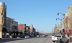
The name of this city is not pronounced like the nearby state of Arkansas, but rather as /ɑːrˈkænzəs/ (the final "s" is pronounced). Over the years there has been much confusion about the regional pronunciation of "Arkansas," which locals render as /ɑːrˈkænzəs/ rather than /ˈɑːrkənsɔː/. Throughout much of Kansas, residents use this alternate pronunciation when referring to the Arkansas River, as well as Arkansas Street in the city of Wichita. Because of this, and for the sake of brevity, Arkansas City is most often referred to as simply Ark City.
History
In 1601, New Mexico Governor Juan de Oñate led an expedition across the Great Plains and found a large settlement of Indians he called Rayados. The most likely location for the Rayado settlement was along the Walnut River in the eastern part of Arkansas City. Extensive remains of Indian settlements have been found along six miles (9.7 km) of the Walnut River. The Rayados were the ancestors of the Indians later called Wichita. Wichita settlements from the 18th century are also found a few miles south of Arkansas City on the west bank of the Arkansas River. (See Deer Creek/Bryson Paddock Sites)
19th century
White settlers first congregated in the area where Arkansas City now stands in the 1860s. The natives referred to the place as "Nichonka," which roughly translates as "place between the waters" — a reference to the confluence of the Arkansas and Walnut rivers.
Settlers supposedly established a town in around 1870. They had difficulty choosing a name; at first they hoped to flatter U.S. Postmaster General John A. J. Creswell (and win a highly sought-after post office) by naming the town Creswell in his honor, but cities in other states had already used the name. The town fathers considered other names, such as Adelphia and Walnut City. Finally, the name Arkansas City was adopted for the town. The first post office in Arkansas City was established on May 16, 1870.
In 1877, the Florence, El Dorado, and Walnut Valley Railroad Company built a branch line from Florence to El Dorado, in 1881 it was extended to Douglass, and later to Arkansas City. The line was leased and operated by the Atchison, Topeka and Santa Fe Railway. The line from Florence to El Dorado was abandoned in 1942. The original branch line connected Florence, Burns, De Graff, El Dorado, Augusta, Douglass, Rock, Akron, Winfield, Arkansas City.
Arkansas City grew steadily through the latter part of the 19th century, and enjoyed a population explosion starting in 1891, when thousands of people moved into the area in anticipation of the Cherokee Strip Land Run. It has been estimated that the city's population swelled from 5,000 to 150,000 (most living in temporary encampments) as the nationally hyped federal land giveaway approached, and shrank back to 5,000 in its aftermath.
A small cave just east of town (in the Flint Hills) was a rest stop for Buffalo Bill Cody when he transited the area working the railroad and killing buffalo.
The James-Younger Gang of outlaws famously hid out in a cave west of town when they rode through the area.
20th century
At the turn of the century, Arkansas City was a rival to Wichita in size and enterprise, boasting several busy rail lines, an elegant opera house, numerous fine hotels, a manufacturing base and a bustling agricultural economy. There was even a famous sanitarium (health spa) at nearby Geuda Springs, served by an electric railway running a triangular route from there to Ark City and Winfield. A popular swimming hole called Paris Lake was located west of downtown; the lake – and the hot springs at Geuda as well – was mired with silt in a flood about 1919. Nearly 20 years later the WPA would build the Paris Park pool in the same spot. African Americans were not allowed to swim in the Paris Park pool during the era of segregation and used a separate facility colloquially referred to as "the black pool" by local residents.
The Kirkwood Wind Engine Company, a former windmill manufacturer, was headquartered in Arkansas City near the turn of the 20th century; the now-defunct Kanotex Refining Company established a refinery and headquarters in the city in 1917.
During the 1920s, Arkansas City had an active group of Ku Klux Klan (KKK). The group was mostly concentrated in south-central and south-east Kansas. The state took action to shut down the group, and most Klans disbanded by 1927.
In 1928, the city's official fall festival, Arkalalah, was inaugurated. This annual event still draws thousands of visitors each October, and features a queen, a carnival, dozens of homegrown fair food vendors and a spectacular parade typically lasting three hours or more. During the 1955 Arkalalah celebration, a retired Santa Fe locomotive was driven on temporary tracks down the city's main street, Summit, to the spot in Wilson Park where it remains today.
The city prospered through much of the 20th century, but by the 1980s, the community was facing economic challenges. The railroads shifted many of their crews to other stops, the old Rodeo meat packing plant, which for a short time was Morrell Meats, closed. The only passenger train that served the city, Amtrak's Lone Star, was discontinued. In 1996 Total Petroleum closed their refinery in Ark City with a loss of 170 jobs. By 2003 other large employers in Cowley County closed operations. The Binney & Smith (Crayola) plant closed with a loss of 400 jobs. Winfield State Hospital and Gordon Piatt Industries were closed in nearby Winfield with a combined loss of 973 jobs. Montgomery KONE Elevator and Central Plains Book Manufacturing at nearby Strother Field were also shuttered.
21st century
Arkansas City is now home to state-of-the-art meat processor Creekstone Farms Premium Beef LLC which employs over 700 workers. Several smaller manufacturing companies are expanding their operations while new start ups are finding a home in Cowley County due in part to the workforce supplied by the two local colleges in the county. Both cities, only 11 miles (18 km) apart, now have large Wal-Mart stores (a new Wal-Mart Supercenter opened in Arkansas City in March 2006, and another has been constructed in Winfield); conversely, both towns' (in Arkansas City – the Burford, the Howard, and the Crest) movie theaters recently closed and were replaced by a single facility halfway between the cities, just south of the Strother Field industrial park. B & B Theatres donated the two downtown buildings to non-profit organizations in each of the respective communities. The Ark City Burford Theatre and Commercial Building is undergoing a transformation/renovation that will become a new community arts center and gathering space. Construction began in spring 2006 on the planned downtown revitalization streetscape.
In 2006, the local physicians in Arkansas City banded together with the South Central Kansas Regional Medical Center (SCKRMC) board and the City of Arkansas City to build a new hospital, which opened in March 2011.
In 2010, the Keystone-Cushing Pipeline (Phase II) was constructed west of Arkansas City, north to south through Cowley County, with much controversy over tax exemption and environmental concerns (if a leak ever occurs).
Geography
Arkansas City is located at 37°3′55″N 97°2′23″W (37.065267, −97.039608). The city is situated along the northern bank of the Arkansas River and to the west of its confluence with the Walnut River. It is located at the junction of U.S. Route 77 and U.S. Route 166, only four miles (6.4 km) north of the Kansas-Oklahoma border. Winfield, the county seat, is 13 miles (21 km) north of Arkansas City along US-77, and Strother Field, a general aviation airport, is about eight miles (13 km) north. Arkansas City is located 54 miles (87 km) southeast of Wichita.
According to the United States Census Bureau, the city has a total area of 9.38 square miles (24.29 km2), of which 9.36 square miles (24.24 km2) is land and 0.02 square miles (0.05 km2) is water.
Climate
The climate in this area is characterized by hot, humid summers and generally mild to cool winters. According to the Köppen Climate Classification system, Arkansas City has a humid subtropical climate, abbreviated "Cfa" on climate maps.
2010 census
As of the census of 2010, there were 12,415 people, 4,802 households, and 3,030 families residing in the city. The population density was 1,326.4 inhabitants per square mile (512.1/km2). There were 5,646 housing units at an average density of 603.2 per square mile (232.9/km2). The racial makeup of the city was 79.4% White, 3.9% African American, 2.7% Native American, 0.6% Asian, 0.1% Pacific Islander, 8.7% from other races, and 4.6% from two or more races. Hispanic or Latino of any race were 17.3% of the population.
There were 4,802 households of which 33.8% had children under the age of 18 living with them, 43.4% were married couples living together, 13.9% had a female householder with no husband present, 5.9% had a male householder with no wife present, and 36.9% were non-families. 31.9% of all households were made up of individuals and 13.6% had someone living alone who was 65 years of age or older. The average household size was 2.47 and the average family size was 3.07.
The median age in the city was 33.8 years. 26.4% of residents were under the age of 18; 12.7% were between the ages of 18 and 24; 23.3% were from 25 to 44; 22.7% were from 45 to 64; and 14.8% were 65 years of age or older. The gender makeup of the city was 48.3% male and 51.7% female.
2000 census
As of the census of 2000, there were 11,963 people, 4,855 households, and 3,102 families residing in the city. The population density was 1,592.5 people per square mile (615.0/km²). There were 5,628 housing units at an average density of 749.2 per square mile (289.3/km²). The racial makeup of the city was 87.15% White, 4.51% African American, 2.69% Native American, 0.64% Asian, 0.02% Pacific Islander, 1.95% from other races, and 3.04% from two or more races. Hispanic or Latino of any race were 4.47% of the population.
There were 4,855 households out of which 30.3% had children under the age of 18 living with them, 48.2% were married couples living together, 11.7% had a female householder with no husband present, and 36.1% were non-families. 31.7% of all households were made up of individuals and 14.9% had someone living alone who was 65 years of age or older. The average household size was 2.36 and the average family size was 2.97.
In the city, the population was spread out with 25.7% under the age of 18, 11.2% from 18 to 24, 24.3% from 25 to 44, 20.9% from 45 to 64, and 17.9% who were 65 years of age or older. The median age was 36 years. For every 100 females there were 88.3 males. For every 100 females age 18 and over, there were 84.8 males.
The median income for a household in the city was $29,158, and the median income for a family was $39,962. Males had a median income of $30,665 versus $19,919 for females. The per capita income for the city was $15,933. About 12.4% of families and 16.4% of the population were below the poverty line, including 20.5% of those under age 18 and 14.5% of those age 65 or over.
Primary and secondary education
Arkansas City Public Schools serves the community.