
Canton Argentat Area 22.41 km² Local time Tuesday 9:48 PM | Intercommunality Pays d'Argentat Population 3,079 (2008) | |
 | ||
Weather 3°C, Wind SW at 5 km/h, 93% Humidity | ||
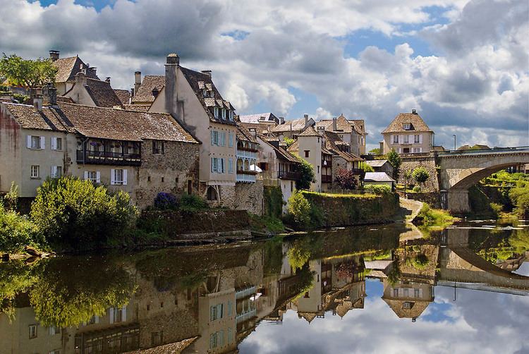
Argentat is a French commune in the Corrèze department in the Nouvelle-Aquitaine region of central France.
Contents
- Map of 19400 Argentat France
- Geography
- History
- Administration
- Twinning
- Demography
- Civil heritage
- Religious heritage
- Notable people linked to the commune
- Philately
- Cinema
- References
Map of 19400 Argentat, France
The inhabitants of the commune are known as Argentacois or Argentacoises
Geography
Argentat is situated on the Dordogne River, 30 km south-east of Tulle, 30 km east by south-east of Brive-la-Gaillarde, and some 15 km south-west of Saint-Privat. Access to the commune is by road D1120 from Saint-Chamant in the north-west passing through the town and continuing south-east to Montvert. The D980 goes from the town north-east to Saint-Privat. The D12 goes south-west from the town to Brivezac. The D33 branches off the D1120 east of the town and goes south to La Chapelle-Saint-Geraud. The D169 goes west from the town to Neuville. The D18 goes north-east from the village and continues north to Saint-Martin-la-Meanne. The D131 branches off the D18 and goes north to Saint-Bazile-de-la-Roche. The D129 goes north-east to the Barrage du Chastang. The D116 goes south from the town to connect to the hamlets of L'Hopital and Les Etables. Apart from the large town area the commune is mostly forest with some farming north and south of the town.
The Dordogne river flows through the town and the commune from north to south with the Maronne river flowing through the commune from the east and joining the Dordogne at the south-western corner of the commune. At the northern border of the commune the Doustre river flows into the Dordogne. Several other streams flow into the Dordogne in the commune including the Ruisseau du Laie.
History
Argentat lies on the border of three regions, Limousin, Midi-Pyrénées and Auvergne, although it officially lies within the Nouvelle-Aquitaine region. It also lies on the Dordogne river below some deep gorges with tumultuous water. This location makes the town of some importance due to the bridges crossing the Dordogne and the important river traffic to Bergerac and Libourne.
Since Gallic times a village perched on a nearby hill, the Puy-du-Tour, has controlled the ford on a protohistoric way connecting Armorica to the Mediterranean. A Roman villa was established on the plain of Longour, a farming-oriented area, close to the Dordogne.
In Merovingian times there was a mint to facilitate trade.
Under the Carolingians, Argentat was the seat of a vicariate - a territorial division under the authority of a count with a priest administering justice.
From the 10th century Argentat is known to have had a priory and a priest in a walled city. The town depended on a religious lord, the Prior of Carennac, and a lay lord, the Viscount of Turenne. Guarding his rights the Viscounty did not grant any charter of liberties and the local community had to be content until, in 1615, parish trustees were appointed to manage it. However, from 1263, the Turennes conceded an important market on the Saint Andrew's day to the town which is the oldest fair in Lower Limousin. Argentat sided with the Huguenots in the Wars of religion which created a troubled situation for half a century.
In the 17th century, with the Counter-Reformation and the subsequent establishment of the Recollects and the Poor Clares around 1633 and the Ursulines in 1637, the struggles gradually subsided. With the annexation of Viscounty to the Crown in 1738, Argentat became the seat of a sub-delegation of the management of Limoges.
The town experienced significant economic growth in the 18th and 19th centuries from Inland navigation by scows, which were known locally as courpet, that allowed the delivery of goods (mainly oak staves for cooperage and carassonne-stakes for grapevines) to the Bordeaux region. This activity began to decline at the end of the 19th century following the outbreak of phylloxera, which devastated the vineyards, and the inauguration of the PO Corrèze railway between Tulle and Argentat in 1904 (this line remained in operation until 1970).
Administration
List of Successive Mayors
(Not all data is known)
Twinning
Argentat has twinning associations with:
Demography
In 2009 the commune had 3,052 inhabitants. The evolution of the number of inhabitants is known from the population censuses conducted in the commune since 1793. From the 21st century, a census of communes with fewer than 10,000 inhabitants is held every five years, unlike larger towns that have a sample survey every year.
Sources : Ldh/EHESS/Cassini until 1962, INSEE database from 1968 (population without double counting and municipal population from 2006)
Civil heritage
There are four sites in the commune that are registered as historical monuments:
Religious heritage
The Church of Saint Peter contains many items that are registered as historical objects:
Notable people linked to the commune
Philately
A postage stamp worth 4.40 francs portraying the Lestourgie dock and beautiful renovated houses in Argentat was issued on 18 June 1994.
Cinema
Several movies and TV series have been shot in the commune. In particular: