
Mountain type Fault-block Elevation 2,695 m First ascent 4 May 1862 Age of rock Cenozoic | Easiest route hike Prominence 2,479 m | |
 | ||
Isolation 2,115 kilometres (1,314 mi) Location Border of Devikulam Taluk, Idukki district and Kothamangalam Taluk, Ernakulam district, Kerala, India Similar Western Ghats, Doddabetta, Chembra Peak, Meesapulimala, Agastya Mala | ||
Anamudi or Anai Mudi ([aːnɐmʊɖi]) is a mountain located in the Indian state of Kerala. It is the highest peak in the Western Ghats and South India, at an elevation of 2,695 metres (8,842 ft), and a topographic prominence of 2,479 metres (8,133 ft). The name Anamudi literally translates to "elephant's forehead," a reference to the resemblance of the mountain to an elephant's head.
Contents
Map of Anamudi, Kannan Devan Hills, Kerala 685561
The first recorded ascent of Anamudi was by General Douglas Hamilton of the Madras Army on May 4, 1862, but it is likely that there had been earlier ascents by local people.
Climatic zones and biomes
Anamudi is the highest peak in the Western Ghats in India, having an elevation of 2,695 metres (8,842 ft). Anamudi is also the highest point in South India. This gives Anamudi its relatively large topographic prominence of 2,479 metres (8,133 ft), the associated key saddle being over 2,000 kilometres (1,200 mi) away at 28°35′20″N 76°27′59″E in Haryana state just to the west of Delhi. The peak is the highest point of the Periyar river basin.
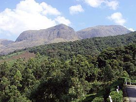
The peak is not exceptionally dramatic in term of steepness or local relief and is a Fault-block mountain. It is located in the southern region of Eravikulam National Park at the junction of the Cardamom Hills, the Anaimalai Hills and the Palani Hills. The nearest town is Munnar, 13 kilometres (8.1 mi). The easiest route to the summit of Anamudi is a technically easy hike on grass slopes, starting from a rolling hill plateau with a base elevation of about 2,000 metres (6,600 ft). The north and south slopes are gentle, while the east and west slopes are steeper, with more difficult rock faces.
Anamudi and the Eravikulam National Park surrounding it is home to the largest surviving population of the Nilgiri tahr(Nilgiritragus hylocrius). Asian elephants, gaur, Bengal tigers, and the Nilgiri marten (Martes gwatkinsii) are some of the species of animals found here . The Anamudi peak area is also habitat of a unique frog Raorchestes resplendens. This newly discovered species is located in the Eravikulam National Park and is restricted to less than three km2 on the summit of Anamudi. The summit of the Anamudi is vegetated with patches of stunted Arundinaria densifolia and Gaultheria fragrantissima (wintergreen), Anaphalis sp., Impatiens and some species of Eriocaulon.