
Isolation 1.9 km (1.2 mi) Elevation 4,206 m Prominence 359 m | Easiest route Many routes at PD First ascent 9 August 1860 | |
 | ||
Similar | ||
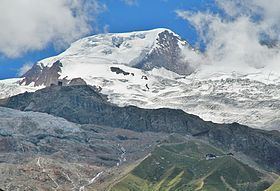
Alphubel 4206 m august 2013
The Alphubel (4,206 m) is a mountain of the Swiss Pennine Alps, located between the valleys of Zermatt and Saas in the canton of Valais. It is part of the Mischabel range, which culminates at the Dom (4,545 m). The summit of the Alphubel consists of a large ice-covered plateau, part of the Fee Glacier on its east side. The west side of the mountain is more rocky and much steeper. It overlooks the Weingartensee.
Contents
Map of Alphubel, 3929 T%C3%A4sch, Switzerland
The nearest settlements are Täsch (north of Zermatt) and Saas-Fee.
The first ascent of the mountain was by Leslie Stephen and T. W. Hinchliff with guides Melchior Anderegg and Peter Perren on 9 August 1860, starting at Täsch and via the south-east ridge and the Alphubeljoch.
Alphubel 4206 m
References
Alphubel Wikipedia(Text) CC BY-SA