Type Reservoir Max. width 600 ft (180 m) Surface elevation 188 m Width 183 m Outflow location Alamitos Creek | Primary outflows Los Alamitos Creek Max. length 4,000 ft (1,200 m) Length 1.219 km Area 25 ha Catchment area 32.37 km² | |
 | ||
Primary inflows Similar Guadalupe Reservoir, Alamitos Creek, Calero Reservoir, New Almaden, Stevens Creek Reservoir | ||
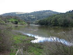
Almaden Reservoir is an artificial lake in the hills south of San Jose, California, U.S.A.. It borders on Almaden Quicksilver County Park.
Contents
Map of Almaden Reservoir, California 95120, USA
The lake is formed by Almaden Dam, built in 1936 across Los Alamitos Creek. Its waters reach the San Francisco Bay by way of the Guadalupe River.
Almaden Dam
Almaden Dam is an earthen dam 110 feet (34 m) high and 500 feet (150 m) long containing 250,000 cubic yards (190,000 m3) of material. Its crest is 615 feet (187 m) above sea level. It is owned by the Santa Clara Valley Water District
References
Almaden Reservoir Wikipedia(Text) CC BY-SA
