
Max. length 2,624 ft (800 m) Surface elevation 188 m Length 800 m | Primary inflows Basin countries United States Max. width 492 ft (150 m) Area 30 ha Width 150 m | |
 | ||
Inflow source Guadalupe River, Guadalupe Creek Similar Almaden Reservoir, Calero Reservoir, Chesbro Reservoir, Alamitos Creek, Mount Umunhum | ||
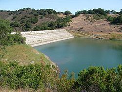
Guadalupe Reservoir is a reservoir in Santa Clara County, California, about 5 miles (8 km) east of the city of San Jose, California. It is at an elevation of 614 feet (187 m). It has a capacity of 3,415 acre feet (4,212,000 m3). The dam is located along Hicks Creek on Guadalupe Creek, a tributary of the Guadalupe River. The Guadalupe River was named by the de Anza expedition on March 30, 1776, Rio de Nuestra Señora de Guadalupe, in honor of the Mexican saint who was the principal patron saint of the expedition. Guadalupe dam and reservoir is one of the six original systems approved for construction by voters in 1934, and was constructed in 1935. The surface area of the reservoir is 74 acres (300,000 m2).
Map of Guadalupe Reservoir, Almaden, CA 95032, USA
References
Guadalupe Reservoir Wikipedia(Text) CC BY-SA