
Type Reservoir Basin countries United States Area 45 ha Width 549 m Primary outflow Arroyo Calero | Primary outflows Arroyo Calero Surface elevation 145 m Length 2.4 km Catchment area 18.49 km² | |
 | ||
Location Santa Clara County, California Primary inflows Managing agency Santa Clara County Parks Similar Calero County Park, Uvas Reservoir, Anderson Lake, Alamitos Creek, Almaden Reservoir | ||
Speed boats at calero reservoir may 22 1938
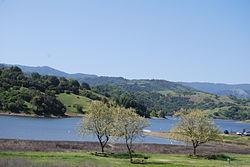
Calero Reservoir is an artificial lake in the Santa Teresa Hills south of San Jose, California in the United States.
Contents
- Speed boats at calero reservoir may 22 1938
- Map of Calero Reservoir San Jose CA USA
- Calero DamEdit
- References
Map of Calero Reservoir, San Jose, CA, USA
The lake is formed by Calero Dam, built in 1935 across Arroyo Calero which is also known as Calero Creek. Its waters reach the San Francisco Bay by way of Los Alamitos Creek and the Guadalupe River.
A 4,455-acre (1,803 ha) county park surrounds the reservoir, and provides fishing ("catch-and-release"), picnicking, and hiking activities. Boating, water-skiing and jet-skiing are permitted in the reservoir.
Calero DamEdit
Calero Dam is an earthen dam 90 feet (27 m) high and 840 feet (260 m) long containing 550,000 cubic yards (420,000 m3) of material. Its crest is 490 feet (150 m) above sea level. It is owned by the Santa Clara Valley Water District.