- right Ōtakine River Discharge 117 m³/s Source Mount Asahi | - elevation 1,835 m (6,020 ft) Length 239 km Basin area 5,390 km² | |
 | ||
- left Shakadō River, Sasahara River, Ōse River, Gohyaku River, Rokkaku River, Arakawa River, Matsu River, Surikami River, Shiroishi River - average 67.3 m/s (2,377 cu ft/s) | ||
Model g7 r447 over abukuma river part 1
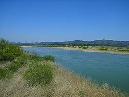
The Abukuma River (阿武隈川, Abukuma-gawa), with a length of 234 km, is the second longest river in the Tōhoku region of Japan and the 6th longest river in Japan. It runs through Fukushima Prefecture and Miyagi Prefecture, rising from springs in the peaks of the Nasu mountains, collecting water from tributaries leaving the Ōu Mountains and the Abukuma Highlands (阿武隈高地, Abukuma-kōchi), then emptying into the Pacific Ocean as a major river. It has a 5,390 km² area watershed, and about 1.2 million people live along its basin.
Contents
- Model g7 r447 over abukuma river part 1
- Map of Abukuma gawa Kawamukai Terashima Iwanuma shi Miyagi ken Japan
- Model g7 r447 over abukuma river part 2
- References
Map of Abukuma-gawa, Kawamukai Terashima, Iwanuma-shi, Miyagi-ken, Japan
The Abukuma River flows north through Fukushima Prefecture's Nakadōri region, past the cities of Shirakawa, Sukagawa, Kōriyama, Nihonmatsu and Fukushima. The portion of the river flowing between Nihonmatsu and Fukushima forms a deep ravine called Hōrai-kyō (蓬莱峡). Crossing the northern edge of the long but low Abukuma hills, the Abukuma River then flows into Miyagi Prefecture, past the city of Kakuda and between Iwanuma and Watari before reaching the Pacific. Abukuma has a tributary called the Arakawa River.
