
Population 62,688 (Nov 2014) | Phone number 0248-22-1111 Local time Sunday 4:08 AM | |
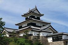 | ||
Weather 0°C, Wind NW at 14 km/h, 92% Humidity Points of interest Komine Castle, Nanko Park, Barrière de Shirakawa, Nanko Shrine, Shirakawasekinomori Park | ||
Shirakawa (白河市, Shirakawa-shi) is a city located in Fukushima Prefecture, in northern Honshū, Japan. As of November 2014, the city had an estimated population of 62,688 and a population density of 205 persons per km2. The total area was 305.3 square kilometres (117.9 sq mi).
Contents
- Map of Shirakawa Fukushima Prefecture Japan
- Geography
- Neighboring municipalities
- Climate
- History
- Economy
- Education
- Post offices
- Railway
- Highway
- Local attractions
- International relations
- Noted people from Shirakawa
- References
Map of Shirakawa, Fukushima Prefecture, Japan
Geography
Shirakawa is located in southern Fukushima prefecture.
Neighboring municipalities
Climate
Shirakawa has a humid subtropical climate (Köppen climate classification Cfa) with warm summers and cold winters. Precipitation is significant throughout the year, but is heaviest from May to October.
History
The area of present-day Shirakawa was part of ancient Mutsu Province and was the location of a barrier gate on the Oshu kaido connecting the capital at Kyoto with the northern provinces. In the Heian period, the Buddhist monk and waka poet Nōin composed the following poem about the region:
In the Edo period the area prospered as a castle town Shirakawa Domain, and was the site of a major battle in the Aizu War during the Meiji restoration. In the Meiji period, it was organized as part of Nakadōri region of Iwaki Province.
The town of Shirakawa was formed on April 1, 1889 with the creation of the municipalities system. On April 1, 1949, Shirakawa was elevated to city status after merging with the neighboring village of Ōnuma. Subsequent mergers occurred in 1954 and 1955 with the inclusion of the villages of Shirasaka, Odagawa, Goka and a portion of Omotegō into the territory of Shirakawa. On November 7, 2005, the villages of Taishin, Higashi, and the remainder of Omotegō (all from Nishishirakawa District) were merged into Shirakawa, increasing its population from 48,297 to approximately 66,000 and territory from 117.67 km2 (45.43 sq mi) to 305.30 km2 (117.88 sq mi).
Economy
Shirakawa has a mixed economy, and is a major commercial center for the surrounding region.
Education
Shirakawa has four high schools, eight junior high schools, and fifteen elementary schools.
Post offices
Shirakawa has nineteen post offices within the boundaries of the city.