
Length 18 km | ||
 | ||
The A145 is an A road in the English county of Suffolk. It runs from the town of Beccles, close to the border with Norfolk, to the village of Blythburgh where it joins the A12 road. It is around 11 miles (18 km) in length and single carriageway throughout.
Contents
Map of A145, Beccles NR34, UK
Route description
The A145 runs through the town of Beccles before passing through a rural area on its route to the A12 at Blythburgh.
Beccles section
Beginning as George Westwood Way, the A145 has its northernmost point at the roundabout with the A146 road on the northern edge of Beccles just within The Broads. It runs southwards for around 800 metres (0.50 mi; 0.80 km) through industrial and retail areas before turning west to become Station Road at a mini roundabout adjacent to Beccles railway station. The road then passes around the edge of Beccles town centre, splitting into two branches at a crossroads. It becomes part of the Beccles one way system: the northward branch runs along London Road and Hungate before turning at Beccles Public Hall to become Market Street; the southward branch becomes Newgate and then Blyburgate before turning to become Peddars Lane.
The roads are reunited at the crossroads of Peddars Lane and London Road to the south of Beccles town centre. Traffic lights control the flow of traffic here, with the B1062 St Mary's Road running west towards Bungay. South of this point the road is known throughout its route as London Road and runs in a generally north-south direction. Before the building of the Beccles northern bypass in the 1980s, the A145 began at the junction of London Road and Blyburgate, with the roads through the town centre being designated as the A146.
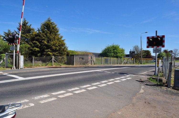
After passing Beccles cemetery and the Butcher's Arms public house, the road is crossed by Regional Cycle Routes 30 and 31. The road then crosses the East Suffolk railway line at a level crossing before running alongside a plastics factory on the southern edge of the town. A Type 22 pillbox can be found alongside the level crossing, built during World War II as part of British anti-invasion preparations.
Rural section
To the south of Beccles the A145 becomes a rural route. A southern relief road for Beccles is planned and will run from a roundabout just south of the town towards Ellough where it will connect the A145 to an industrial area before joining with the A146 at North Cove. The A145 runs through the parishes of Weston, Willingham St Mary and Shadingfield immediately to the south of the town. In Weston it passes the former Duke of Marlborough public house and close to the Grade II* listed Weston Hall, built in the late 16th century for John Rede, and the 12th century parish church of St Peter which can be seen from the road at the junction with Church Lane. A small section of Willingham St Mary follows before the route reaches Shadingfield where it passes the Shadingfield Fox public house, the village hall and a water tower. The village is linear and extends for around 1 mile (1.6 km); at its southern edge the road passes the Grade I listed medieval church of St John the Baptist and Hill Farmhouse, dating from the 16th century and Grade II* listed.
South of Shadingfield the A145 passes through the parish of Brampton with Stoven. The village of Brampton is dispersed across a wide area either side of the road. At Brampton crossroads it passes the former Dog public house which closed in 1999 and is now a guesthouse. The crossroads were the site of the original Brampton Primary School and a post office, both of which are now private residences. A cast iron milestone stands at the crossroads alongside the village sign. Dating from 1822, the milestone was discovered and restored in 2010 before being replaced. It indicates that Beccles is 5 miles to the north, Great Yarmouth 19 miles and Norwich 23 miles and that the crossroads are 104 miles from London. A number of similar milestones can be seen along the road in this section. From the crossroads Station Road to the west leads to Brampton railway station, some 2 miles (3.2 km) away, whilst Southwold Road runs eastward, passing Brampton Primary School before heading towards Stoven and Wangford.
The A145 passes the Grade I listed Brampton church, dedicated to St Peter and with a 15th-century tower, before turning sharply and reaching a junction with the B1124 Halesworth road. It continues into the parish of Sotherton, passing the former Cross Bows Inn alongside the road, and then into Wangford with Henham where it passes along the western edge of Henham Park, the site of the Latitude festival, a major music and arts festival held annually in July, and the Grand Henham Steam Rally, held in September. The park was the site of Henham Hall, originally a Tudor house dating from the early 16th century. The original building burned down in 1773 and was replaced with a Georgian mansion in 1790. This was pulled down in 1953. An archaeological dig of the site featured in the Time Team television programme in January 2013.
The road then runs into the parish of Blythburgh where a junction with the B1123 at Bulcamp leads towards Halesworth. The Battle of Bulcamp occurred here in 653 or 654 AD between the forces of Anna of East Anglia and Penda of Mercia. Anna, the King of East Anglia, was defeated and killed along with his son Jurmin. Both are believed to have been buried at Blythburgh Priory. The main A12 road is reached at the southern end of the A145, around 0.4 miles (0.64 km) north of the village of Blythburgh, at a junction overlooking the estuary of the River Blyth.
Road safety
The A145 is generally straight and has no record of significant safety issues. It has generally been rated as medium or low–medium risk in European Road Assessment Programme (EuroRAP) surveys. There were 8 fatalities associated with road traffic accidents along its length between 1999 and 2010. Accidents have occurred at Henham Park, Brampton and Willingham St Mary and Shadingfield. The road is limited to 30 miles per hour in Beccles, for a distance of around 1 mile (1.6 km) in Shadingfield and either side of Brampton crossroads. On the approach to the A12 at Blythburgh a speed limit of 40 mph is applied. Suffolk Constabulary operate mobile speed cameras on the road to enforce speed limits. On-road cycle lanes, footpaths and pedestrian crossings are used within Beccles to support road safety. Outside of Beccles there is limited street lighting in place along the road.
The Latitude Festival attracts a significant amount of road traffic and delays around the site at Henham and the junction of the A145 with the A12 are common over the festival weekend. The A145 and other approach roads are generally subject to temporary speed limits, diversions, no stopping orders and one way systems to ease traffic flow. Organisers have attempted to encourage festival goers to use cycle or bus transport to minimise congestion.