
First system formed May 19, 2003 Name Nora Total storms 16 | Last system dissipated October 26, 2003 Total depressions 17 Hurricanes 7 | |
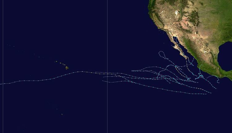 | ||
The 2003 Pacific hurricane season was the first season to feature no major hurricanes – storms of Category 3 intensity or higher – since 1977. It produced an unusually large number of tropical cyclones which affected Mexico. The most notable cyclones during the year were Hurricanes Ignacio and Marty, which killed 2 and 12 people in Mexico, respectively, and were collectively responsible for about US$1 billion (2003 USD) in damage. Three other Pacific storms, two of which were hurricanes, and three Atlantic storms also had a direct impact on Mexico. The only other significant storm of the season was Hurricane Jimena, which passed just to the south of Hawaii, the first storm to directly threaten Hawaii for several years.
Contents
- Preseason forecasts
- Tropical Storm Andres
- Tropical Storm Blanca
- Tropical Storm Carlos
- Tropical Storm Dolores
- Tropical Storm Enrique
- Tropical Storm Felicia
- Tropical Storm Guillermo
- Tropical Storm Hilda
- Tropical Depression One C
- Hurricane Ignacio
- Hurricane Jimena
- Tropical Storm Kevin
- Hurricane Linda
- Hurricane Marty
- Hurricane Nora
- Hurricane Olaf
- Hurricane Patricia
- Storm names
- Season effects
- References
The season officially started on May 15, 2003, in the eastern Pacific Ocean, and on June 1, 2003, in the central Pacific, and lasted until November 30, 2003. These dates conventionally delimit the period of each year when most tropical cyclones form in the northeastern Pacific Ocean. The season saw 16 tropical storms form, of which 7 became hurricanes, which is about average. However, this season was the first Pacific hurricane season since 1977 to have no systems become major hurricanes by reaching Category 3 or higher on the Saffir–Simpson hurricane scale.
Preseason forecasts
On June 12, 2003, NOAA published a forecast for the East Pacific hurricane season, the first time it had done so. The scientists predicted a 50% chance of below normal activity this season, due to the expectation that La Niña conditions would develop. La Niña conditions generally restrict tropical cyclone development in the northeast Pacific, which is the opposite of its effect in the Atlantic.
On May 19, 2003, NOAA published its forecast for the Central Pacific hurricane season. The forecast called for a slightly below-average level of activity in 2003, due to the same forecast of the onset of La Niña which would later prompt the low forecast for the Eastern Pacific.
There were 16 named storms and 7 hurricanes during the 2003 Pacific hurricane season, which is comparable with the long-term averages. However, there were no major hurricanes (Category 3 or higher on the Saffir–Simpson hurricane scale); this was the first time this had happened in the eastern Pacific since 1977, and is well below the long-term average of four. The first hurricane, Ignacio, formed on August 24. This is the latest formation of the first hurricane of a season recorded in the east Pacific since reliable satellite observation began in 1966.
Whilst the total activity was below average, there was an unusually high number of landfalls in Mexico. A total of eight Pacific and North Atlantic tropical cyclones had a direct impact in Mexico in 2003, second only to 1971, when 9 did so. This is well above the long-term average of 4.2 Atlantic and east Pacific storms affecting Mexico. Five Pacific storms impacted Mexico, of which Hurricanes Ignacio and Marty both hit the state of Baja California Sur as hurricanes. The combined damage from the two hurricanes totaled about US$1 billion (2003 USD). Two other storms hit mainland Mexico as tropical storms and a third as a tropical depression. Three storms hit Mexico within a very short space of time, the Pacific hurricanes Nora and Olaf, and the Atlantic Tropical Storm Larry. As a result of the flooding caused by these storms, disaster areas were declared in 14 states.
Activity in the Central Pacific was below average, with only one tropical depression forming in the basin and one hurricane entering the basin from the east Pacific. In addition, a third system, Tropical Storm Guillermo, weakened to a remnant low just to the east of the Central Pacific Hurricane Center's area of responsibility. Although activity was generally low, Hurricane Jimena was the first direct threat to the Hawaiian Islands for several years and a hurricane watch was issued for the island of Hawaii. Jimena passed to the south, but still brought tropical-storm-force gusts and heavy rain to the island.
Tropical Storm Andres
A tropical wave developed into a tropical depression on May 19 well to the south of Mexico as it moved west. A good outflow developed and it became a tropical storm the next day, before reaching its peak strength with winds of 60 mph (95 km/h). Increasing shear prevented any further development as the storm moved quickly west-northwest. On May 25, the shear and a reduction in water temperatures weakened Andres to a tropical depression, and it dissipated soon after. The storm did not approach land.
Tropical Storm Blanca
Tropical Depression Two-E formed when an organized tropical wave interacted with another disturbance near the southwestern Mexican coast early on June 17. The storm strengthened and became Tropical Storm Blanca 12 hours later. The storm moved slowly to the west and reached its peak on June 18 with 60 mph (95 km/h) winds. Although Blanca never developed a true eye, at its peak there was a ring of convection resembling one. Under the influence of strong shear from the southeast, Blanca began to weaken and move erratically. The storm degenerated to a remnant low on June 22 and lasted a further two days. There were no effects from Blanca on land.
Tropical Storm Carlos
Tropical Storm Carlos formed on June 26 from a tropical wave to the south of Mexico. It quickly strengthened as it approached the coast, and early on June 27 Carlos moved ashore in Oaxaca with winds of 65 mph (100 km/h). The storm rapidly deteriorated to a remnant low, which persisted until dissipating on June 29. Carlos brought heavy rainfall to portions of southern Mexico, peaking at 337 mm (13.3 in) in two locations in Guerrero. Throughout its path, the storm damaged about 30,000 houses, with a monetary damage total of $86.7 million pesos (2003 MXN, US$8 million 2003 USD). At least nine people were killed throughout the country, seven due to mudslides and two from river flooding; there was also a report of two missing fishermen.
Tropical Storm Dolores
Convection developed within an area of low pressure embedded in a tropical wave as it moved west. The disturbance organized into Tropical Depression Four-E on July 6 well to the south-southwest of the tip of the Baja California Peninsula. It soon strengthened further into Tropical Storm Dolores as it moved to the northwest and reached its peak as a minimal tropical storm with winds of 40 mph (65 km/h). However, wind shear had an adverse effect on Dolores, and it weakened back into a depression 12 hours after becoming a tropical storm. The northwest motion brought it over colder water and it dissipated on July 9.
Tropical Storm Enrique
On July 10, a tropical wave formed into Tropical Depression Five-E. The storm became more organized and was named Tropical Storm Enrique the next day at an unusually high latitude. The storm continued to strengthen and at one point was forecast to briefly become a hurricane. This did not occur as the storm reached its peak strength with 65 mph (100 km/h) winds. It maintained this strength before moving over significantly cooler water late on July 12. Due to the cold water temperatures Enrique rapidly weakened, despite favorable atmospheric conditions. The storm degenerated into a remnant low late on July 13 and continued to move west before dissipating after a further 3 days. Enrique had no effects on land, but there were two ship reports of tropical storm force winds.
Tropical Storm Felicia
A tropical wave passed over Central America on July 12 and started to become more organized two days later. It formed into a tropical depression on July 17 as it continued to move to the west. The depression became Tropical Storm Felicia the next day and as there was low shear over the system, the NHC predicted that it would become a minimal hurricane. However, the storm remained disorganized and peaked with 50 mph (85 km/h) winds late on July 18. The storm gradually weakened under increasing shear as it headed west, weakening back to a tropical depression on July 20. The remnant low entered the central Pacific before dissipating on July 24 well to the east of Hawaii. Felicia had no effect on land.
Tropical Storm Guillermo
A weak surface low developed within a tropical wave on August 6 and the convection associated with it became isolated from that of the wave. The circulation of the system became better defined and a Tropical Depression, Seven-E, formed early the next day. Although the depression was initially forecast to dissipate quickly, it became more organized as it moved to the west. On August 8 it became Tropical Storm Guillermo and it reached its peak strength with 60 mph (95 km/h) winds that day. It maintained this strength for a full day, until outflow from the developing Tropical Storm Hilda to its east disrupted its convection. The remnant low entered the central Pacific shortly before dissipating on August 13.
Tropical Storm Hilda
A tropical wave developed persistent thunderstorm activity on August 5, which soon became more organized, forming into Tropical Depression Eight-E to the south of Cabo San Lucas. An impressive outflow pattern caused the NHC to predict an intensification to hurricane strength, but strong easterly shear affected the system. The depression became Tropical Storm Hilda on August 10 but did not get any stronger than a minimal tropical storm with winds of 40 mph (65 km/h). Hilda moved west-northwest before it moved over colder waters, which caused it to weaken. Low-level flow forced the weakening cyclone westwards and it dissipated on August 13, having never approached land.
Tropical Depression One-C
The only tropical cyclone to form in the central Pacific in 2003 developed on August 15, and resulted from an interaction between remnants of Tropical Storm Guillermo and a non-tropical low. Unfavorable wind shear prevented the development of the depression and weakened as it drifted to the west. It weakened to a remnant low on August 17 and never regained depression strength. The remnant passed just south of Johnston Atoll before it crossed the International Date Line on August 20. The storm had a minimal effect on the weather of the Hawaiian Islands.
Hurricane Ignacio
A tropical wave organized into a distinct area of disturbed weather just south of the Mexican port of Manzanillo, Colima, on August 22 and gradually moved to the northwest. It became Tropical Depression Nine-E off Cabo Corrientes in the state of Jalisco two days later and under the influence of favorable atmospheric conditions rapidly strengthened. It was named Tropical Storm Ignacio on August 25 before it peaked as a 105 mph (165 km/h) hurricane on August 26, the first of the season. Ignacio entered the southern Gulf of California before it made landfall just to the east of La Paz, Baja California Sur. Ignacio weakened overland and dissipated early on August 28 over central Baja California.
Due to the storm's slow movement, rainfall was high and the resulting flooding was severe, and Ignacio was responsible for approximately US$21 million of damage. Two rescue workers drowned in the flood waters brought by the storm and some 10,000 people were evacuated to shelters.
Hurricane Jimena
On August 28, an area of disturbed weather within the Intertropical Convergence Zone developed into Tropical Depression Ten-E, some 1725 miles (2775 km) east of the Hawaiian Islands. The storm rapidly developed over warm ocean waters, gaining an eye shortly before it became Hurricane Jimena on August 29. The storm moved to the west, entering the central Pacific as it continued to strengthen. After reaching its peak strength with 105 mph (165 km/h) winds 800 miles (1300 km) to the east of Hawaii it began to weaken as a result of increased shear. The storm passed about 120 miles (195 km) to the south of the southern tip of Hawaii on September 1, just after losing hurricane strength. The storm then moved west, south of the archipelago, becoming a tropical depression on September 3. The weakening Jimena crossed the International Date Line before dissipating on September 5.
The storm brought 6 to 10 inches (150 to 250 mm) of rain and 11 foot (3.3 m) surf to the island of Hawaii. There were also tropical storm force winds recorded on several of the Hawaiian Islands, but there was no significant damage.
Tropical Storm Kevin
A large low pressure area developed within a tropical wave and organized slowly into Tropical Depression Eleven-E on September 3 south-southwest of the tip of Baja California. The broad wind field prevented rapid intensification and the system reached tropical storm strength on September 4. Although wind shear was light, Kevin weakened into a depression after just six hours, as it moved over colder waters. On September 6 the system degenerated to a non-convective low pressure area, which managed to survive for four days before finally dissipating. Tropical Storm Kevin had no effects on land.
Hurricane Linda
Convection began to increase in a tropical wave on September 9 and a few days later a surface low developed. On September 12 it organized into Tropical Depression Twelve-E to the southwest of the Mexican port of Manzanillo, Colima. The cyclone moved to the northwest, becoming a tropical storm on September 14 before reaching its peak strength as a Category 1 hurricane with 75 mph (120 km/h) winds. The National Hurricane Center predicted further strengthening, but this did not occur and Linda weakened back to a tropical storm after just 12 hours as a hurricane. As the storm continued to weaken it turned to the west and then to the southwest, becoming a tropical depression on September 17. The remnant drifted to the southwest and finally dissipated on September 26. There were no reports of any effects from this storm.
Hurricane Marty
A tropical wave moved into the Pacific Ocean on September 10 and the convection associated with it gradually increased. By September 16, while the system was south-southeast of Cabo San Lucas, it organized into Tropical Depression Thirteen-E. The depression strengthened as it headed towards the Baja California Peninsula, becoming a tropical storm on September 19 and a hurricane two days later. Hurricane Marty reached its peak strength on September 22, just before it made landfall at Cabo San Lucas, when it was packing winds of 100 mph (155 km/h). After moving over the southern tip of the peninsula Marty moved up the western coast of the Gulf of California, gradually weakening as it did so. The storm weakened to a tropical depression on September 23 and dissipated two days later after meandering over the northern Gulf.
Hurricane Marty was the deadliest storm of the 2003 Pacific hurricane season and was responsible for 12 deaths and either damaged or destroyed over 4,000 homes. It brought heavy rainfall to the entire region and some rain affected the Southwest United States. A 5-foot (1.5 m) storm surge flooded parts of La Paz, Baja California Sur, and sank 35 yachts moored in various ports. Marty was also the costliest east Pacific storm of the year and was responsible for US$50 million of damage in western Mexico.
Hurricane Nora
A tropical wave moved over Central America on September 25 and moved parallel to the south Mexican coast. It became more organized on October 1 and developed into Tropical Depression Fourteen-E to the south of the Baja California Peninsula. It continued to strengthen as it moved northwest in favorable conditions, becoming a tropical storm the next day. On October 4 it became a hurricane and reached its peak that day with 105 mph (165 km/h) winds. Nora made a sharp turn to the east and began to weaken, as the result of the influence of a mid-level trough and the outflow from Hurricane Olaf to the southeast. The cyclone rapidly weakened before it made landfall just north of Mazatlán, Sinaloa, on October 9. Nora dissipated over land soon after landfall. Hurricane Nora was the strongest storm of the season and brought heavy rain to the state of Sinaloa, but there was no significant damage or casualties.
Hurricane Olaf
A tropical wave became increasingly organized on October 2 to the south-southeast of Acapulco and developed into Tropical Depression Fifteen-E the next day. The depression strengthened into Tropical Storm Olaf six hours after forming as it moved to the northwest in a low shear environment. Olaf reached its peak strength as a minimal hurricane with 75 mph (120 km/h) winds on October 5 and developed a partial eyewall. The storm soon became disorganized and was only a hurricane for a few hours, before turning towards the Mexican coast. Olaf made landfall near Manzanillo, Colima, on October 7 and soon dissipated overland.
The storm caused severe flooding in the states of Jalisco and Guanajuato which damaged crops, roads and over 12,000 houses. However, there were no deaths as a result of Hurricane Olaf.
Hurricane Patricia
On October 20 the convection associated with a tropical wave became more organized, and Tropical Depression Sixteen-E formed to the south of Acapulco. It soon became Tropical Storm Patricia and reached hurricane strength on October 21, as it moved further west. 12 hours later, its winds had increased to 80 mph (130 km/h) and the NHC forecast further strengthening. However, on October 22, increasing westerly shear caused Patricia to weaken to below hurricane strength. The storm weakened further to a depression on October 25, and it dissipated the next day, ending the season. Hurricane Patricia had no effects on land.
Storm names
The following list of names was used to name storms that formed in the northeast Pacific in 2003. Names that were not assigned are marked in gray. No names were retired by the World Meteorological Organization, therefore this list was used again in the 2009 season. This is the same list which was used for the 1997 season except for Patricia, which replaced Pauline. The name Patricia was previously used in 1970 and 1974.
For storms that form in the Central Pacific Hurricane Center's area of responsibility, encompassing the area between 140 degrees west and the International Date Line, all names are used in a series of four rotating lists. The next four names that were slated for use in 2003 are shown below; however, none of them were used.
Season effects
This is a table of all the storms that have formed in the 2003 Pacific hurricane season. It includes their duration, names, landfall(s), denoted in parentheses, damages, and death totals. Deaths in parentheses are additional and indirect (an example of an indirect death would be a traffic accident), but were still related to that storm. Damage and deaths include totals while the storm was extratropical, a wave, or a low, and all the damage figures are in 2003 USD.