
Highest winds 169 km/h | Fatalities 19 | |
 | ||
Formed October 30, 1935 (1935-10-30) Dissipated November 8, 1935 (1935-11-09) Lowest pressure 964 mbar (hPa); 28.47 inHg Damage $5.5 million (1935 USD) Date 30 October 1935 – 8 November 1935 Affected areas Atlantic Ocean, Bahamas, Florida Similar 1935 Labor Day hurricane, 1926 Miami hurricane, 1935 Jérémie hurricane, 1935 Cuba hurricane, 1928 Okeechobee hurricane | ||
The Yankee hurricane of 1935 was a rare Category 2 hurricane that affected the Bahamas and South Florida in November. It remains the only tropical cyclone to affect Miami from the northeast in November. The sixth tropical cyclone and fifth hurricane of the 1935 Atlantic hurricane season, it developed 227 miles (366 km) east of Bermuda. It strengthened to a hurricane on November 1, initially posing a threat to the Carolinas. Subsequently, the cyclone turned southwest. It attained its peak intensity on November 3, and it made landfall near Miami Beach on November 4. The hurricane's unusual approach toward Florida and late arrival earned it the nickname of the Yankee Hurricane.
Contents
Meteorological history
The cyclone originated as an extratropical system east of Hamilton, Bermuda. The system was isolated from a large upper-level trough that stretched from the Lesser Antilles to a low pressure area near the Faroe Islands. A polar ridge of high pressure was situated north of Bermuda, producing anomalous easterly trades at an unusually high latitude. The easterly flow blew over a long fetch of open waters, thus producing low-level convergence. Gradually, instability probably supported convective activity, and the cyclone slowly acquired tropical characteristics. On October 30, the system became a tropical storm with maximum sustained winds of 40 mph (65 km/h).
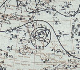
Initially, the cyclone moved westward. On November 1, the storm strengthened to a Category 1 hurricane, and it attained peak winds of 80 mph (130 km/h). The tropical cyclone temporarily threatened the Carolinas. On November 2, the hurricane reached its closest approach to Cape Hatteras; the center was located less than 145 miles (230 km/h) off the coast. The cyclone's wind field remained narrow, and Hatteras recorded peak gusts of 40 mph (65 km/h). The cyclone turned south, under the influence of northerly winds from a high pressure system. On November 3, a ship reported a minimum pressure of 964 mbar (28.48 inHg) north of the Abaco Islands. However, this value remains unofficial, pending reanalysis. On November 4, the hurricane, with maximum sustained winds of 75 mph (120 km/h), made landfall north of Miami Beach near the present location of Bal Harbour, Florida. The hurricane's lowest central pressure in Florida was recorded at 973 mbar (28.73 inHg) in Miami, Florida.
The hurricane traversed southern Florida and weakened over land. Later, the cyclone entered the Gulf of Mexico north of Cape Sable. On November 6, the tropical system weakened to a strong tropical storm, and it turned northwest. On November 7, the circulation turned east, and the cyclone weakened to a remnant low pressure area. On November 8, the system dissipated 50 miles (81 km) southwest of Saint Petersburg.
A recent reanalysis paper assesses the tropical cyclone as a Category 2 hurricane at peak intensity and landfall. However, this analysis not been accepted by the Atlantic hurricane reanalysis project, which has reanalyzed all Atlantic hurricane seasons prior to 1921.
Preparations
Shops and residences were "boarded up" in Nassau. Precautionary hurricane signals were hoisted along the Florida east coast from Titusville to Miami, and the center was expected to make landfall between Miami and West Palm Beach. Later, hurricane warnings were issued from Palm Beach to Naples. 200 men were evacuated from the Snake Creek area in the upper Florida Keys. Workers in the Florida Keys were transported to concentration points in Miami and Homestead. Maritime interests in the Gulf of Mexico were also warned, though the cyclone's remnants remained off the west coast of Florida.
Impact
The cyclone produced winds of 60 mph (95 km/h) on Grand Bahama. The duration of hurricane force winds ranged from 1–3 hours in the Abaco Islands, and five sponge fishing vessels were lost due to the hurricane. The cyclone caused 14 deaths in the islands. In Fort Lauderdale, winds unroofed several homes, and canals overflowed. In South Florida, the hurricane dismantled communication lines, and "telegraph companies relayed" messages via Jacksonville and Atlanta. High waves flooded Miami Beach. Ten feet (3.5 m) of the Miami Beach causeway was eroded, and police halted traffic between Miami Beach and the mainland. The death toll in Florida was low because of well executed warnings and advisories. Winds shattered numerous plate glass windows in Miami's business district, while signs, roofing materials, and vegetation littered streets. 50 homes lost their roofs in Hollywood and Dania, and the oceanfront boardwalk was destroyed. Precipitation damaged equipment at the Hollywood Beach Hotel, where many windows were broken. Construction standards were improved in the aftermath of the 1928 Okeechobee Hurricane, reducing damages in subsequent storms. 35 people were treated for injuries at local hospitals. Southeastern Miami was flooded by three feet (915 mm) of water. The hurricane produced light rainfall in Miami that peaked at 4.04 inches (102.5 mm). Five deaths were reported in Florida. Total damages in Florida reached $5,500,000 in the Miami–Fort Lauderdale area.