
First system formed May 15, 1935 Total depressions 10 Hurricanes 5 | Last system dissipated November 14, 1935 Total storms 8 | |
 | ||
Name "Labor Day" (Third most intense hurricane in the Atlantic basin) | ||
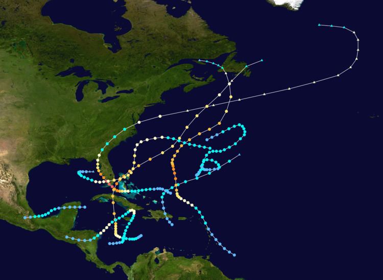
The 1935 Atlantic hurricane season ran from June 16 through October 31, 1935. The 1935 season featured below average activity, but it was eventful. A Category 1 hurricane in the Caribbean killed an estimated 2,150 people in the Greater Antilles and Central America. A Category 3 storm hit central Cuba and grazed Miami. An extratropical hurricane hit Newfoundland. The third tropical cyclone of the season struck the Florida Keys in southern Florida as a Category 5 hurricane; it remains the strongest landfalling hurricane in the United States (and anywhere in the Atlantic basin). A rare November hurricane also affected the Miami—Fort Lauderdale area.
Contents
- Tropical Storm One
- Hurricane Two
- Hurricane Three
- Tropical Storm Four
- Hurricane Five
- Hurricane Six
- Hurricane Seven
- Tropical Storm Eight
- Other systems
- Season effects
- References
The season's activity was reflected with an accumulated cyclone energy (ACE) rating of 106 units, ranking it as a near-normal year. ACE is, broadly speaking, a measure of the power of the hurricane multiplied by the length of time it existed, so storms that last a long time, as well as particularly strong hurricanes, have high ACE. It is only calculated for full advisories on tropical systems at or exceeding 39 mph (63 km/h), which is tropical storm strength.
Tropical Storm One
A tropical depression developed in the northeastern Caribbean Sea on May 15. It soon struck Dominican Republic and moved northward across the island. After emerging into the Atlantic Ocean, the depression strengthened into a tropical storm on May 16. The storm then accelerated northeastward and became extratropical. on May 18, while located east-southeast of Bermuda.
Hurricane Two
A hurricane was detected near the Leeward Islands on August 18. Moving west-northwest, the storm gradually intensified into a Category 2 hurricane the following day. On August 20, the system began to curve northward and later north-northeast, and the hurricane reached its peak of 135 miles per hour (217 km/h) on August 22. The hurricane later passed just west of Bermuda late on August 22 as a slightly weaker 115 miles per hour (185 km/h) hurricane. On August 24, the hurricane weakened to a Category 2 hurricane and began to turn more to the north. Continuing to curve northwestward on August 25, the hurricane continued to weaken to a Category 1 hurricane, later striking Newfoundland as an extratropical storm on August 26, doing noticeable damage. The storm later dissipated on the same day.
Penned as the "worst gale in 36 years", the remnants of Hurricane Two battered Newfoundland with damaging winds. Charlottetown on Prince Edward Island received 5.6 in (140 mm) of rain over a three-day span; however, how much of this total was directly from the hurricane is unknown. In St. John's, Newfoundland, wind gusts averaged 52 mph (83 km/h) and caused extensive property damage. Total losses were estimated in the thousands of dollars. Communication lines across the island were downed, though the greatest effects were felt offshore. Gale-force winds and rough seas wrecked multiple schooners off the coast of Newfoundland, claiming an estimated 50 lives. Every ship that set sail within a day of the storm was damaged. Six people drowned when the Walter sank near Trepassey. The S.S. Argyle was dispatched on search and rescue for three other vessels; however, upon discovery of the ships they reported no sign of life and their crew are believed to have been washed overboard. In the days following the storm, wrecks of schooners, such as the Carrie Evelyn, washed ashore.
Hurricane Three
The strongest storm of the season was the Labor Day Hurricane that made landfall in the Florida Keys on September 2. The storm was first detected as a disturbance east of the Bahamas. It strengthened very rapidly as it moved across the Straits of Florida. It made landfall on Craig Key in the Upper Keys as a small but intense Category 5 major hurricane. A pressure reading of 892 millibars (26.35 inHg) was recorded near where the center crossed the islands. The pressure reading makes the Labor Day Hurricane the most intense to ever strike the U.S. as well as in the entire Atlantic Basin. It ranks third on the list of the most intense Atlantic hurricanes based on lowest pressure, behind only Hurricane Gilbert of 1988 (888 mb), which did not strike the U.S., and Wilma of 2005 (882 mb).
After crossing the Keys, the storm proceeded up the Florida west coast, bringing flooding rains all along the way. The storm made its final landfall on the sparsely populated Apalachee coast near Cedar Key on September 5. It moved inland and then curved back out to sea and later dissipated in the North Atlantic on September 10. A total of 408 people were killed in the Keys and the damage in the area of landfall was catastrophic. Portions of the Florida East Coast Railway in the Upper Keys were severely damaged or destroyed. The hurricane also washed an evacuation train off the tracks and many who were awaiting rescue, including World War I veterans who were living and working in the Keys as part of a government relief project, were killed.
Tropical Storm Four
A short-lived tropical storm formed west of the Yucatán Peninsula on August 31. The tropical cyclone strengthened to its peak with winds of 60 miles per hour (97 km/h) over the Bay of Campeche. The system eventually weakened to a depression on September 2 shortly after making landfall in mainland Mexico. The system weakened after moving inland and dissipated later on the same day.
Hurricane Five
The origin of this hurricane is uncertain, though it is believed to have coalesced into a tropical depression over the central Caribbean Sea on September 23. The disturbance gradually organized as it moved to the west, and strengthened to tropical storm intensity less than a day after formation and further to a hurricane by September 25. The hurricane subsequently curved northward from its initial westward motion. On September 27, the storm reached major hurricane intensity before making landfall near Cienfuegos, Cuba as a Category 3 hurricane the next day. After passing the island, the hurricane reintensified, and reached a peak intensity with a minimum barometric pressure below 945 mbar (hPa; 27.91 inHg) and maximum sustained winds of 140 mph (220 km/h), making it a Category 4 hurricane. At the same time, the tropical cyclone passed over the Bahamian island of Bimini before moving out to sea. As it progressed northeastward, the hurricane gradually weakened before transitioning into an extratropical storm on October 2. The extratropical remnants traversed Newfoundland before dissipating later that day.
The hurricane caused widespread destruction in areas of the western Atlantic. In Jamaica, the storm's strong winds and heavy rain destroyed roughly 3 percent of the island's banana production and damaged road networks. Damage on the island country totaled to $2.7 million and two people died. In Cayman Brac, strong winds damaged infrastructure and crops, though no fatalities resulted. Most of the cyclone's deaths occurred in Cuba, where the storm made its first landfall. The hurricane's effects left a 100 mi (160 km) wide swath of damage across the country. A large storm surge destroyed low-lying coastal towns, particularly in Cienfuegos where numerous homes were destroyed and 17 people died. Throughout the nation, the hurricane wrought $12 million in damage and killed 35 people. As it crossed Cuba, widespread evacuation procedures occurred in southern areas of Florida, heightened due to the effects of a disastrous hurricane which struck less than a month prior. However, damage there was only of moderate severity. Passing directly over Bimini in The Bahamas, a large storm surge destroyed nearly half of the island; 14 people were killed here. Farther north, the storm had slight impacts in Bermuda and Atlantic Canada, though a person drowned off of Halifax, Nova Scotia, due to rough seas.
Hurricane Six
A tropical storm formed late in the season on October 18 in the south-central Caribbean Sea with winds of 40 miles per hour (64 km/h). Moving slowly north-northeast, the system strengthened quickly into a hurricane on October 20, and it attained its first peak intensity of 85 miles per hour (137 km/h) just south-southeast of Kingston. The hurricane slowed on October 22 just east of Jamaica. Later, the hurricane made landfall near Santiago de Cuba early on October 23. Continuing to turn southwest on October 23, the system weakened to a 60 miles per hour (97 km/h) tropical storm in the western Caribbean. The system began to reintensify shortly thereafter, regaining hurricane status late on October 24 and regaining a second peak intensity of 65 miles per hour (105 km/h) on October 25. On October 26, it made landfall in Honduras as a Category 1 hurricane. The hurricane maintained intensity after moving inland before weakening to a tropical storm on October 26, eventually weakening to a tropical depression on October 27 over interior Central America. The system dissipated shortly thereafter. This storm caused catastrophic flooding that killed roughly 2,150 people in Haiti and Central America and caused upwards of $2 million in damages (1935 dollars).
Hurricane Seven
A rare early November hurricane strike in the Miami area, this storm began as a tropical storm near Bermuda on October 30. Moving westward, the storm strengthened to a 75 miles per hour (121 km/h) Category 1 hurricane on November 1 while initially threatening the North Carolina coastline. The system began to turn southwest on November 2, however, while continuing to strengthen to its peak of 80 miles per hour (130 km/h), while a ship recorded a minimal pressure of 980 mbar. The hurricane continued moving slowly south-southwest while weakening slightly, eventually making landfall near Miami Beach, Florida, as a 75 miles per hour (121 km/h) minimal hurricane on November 4 with a measured pressure of 973 mbar at landfall. The system crossed the southern end of the Florida peninsula shortly thereafter, eventually entering the southeast Gulf of Mexico as a minimal hurricane near the Dry Tortugas on November 5. The hurricane then weakened into a tropical storm while beginning a slow clockwise loop in the eastern Gulf, eventually curving back east while weakening to a depression just west of St. Petersburg late on November 7. The system dissipated just offshore on November 8. It had killed 19 people and caused upwards of $5.5 million in uninflated damage. The hurricane's unusual approach toward Florida and late arrival earned it the nickname of the Yankee Hurricane.
Tropical Storm Eight
This storm moved in an erratic way and existed from November 3 to November 14.
Other systems
In addition to the eight gale-force systems identified within HURDAT, two other cyclones were classified as tropical depressions. The first of these developed over the northern Gulf of Mexico on August 23. On this day, a ship observed sustained winds of 35 mph (55 km/h)—the highest in relation to the system. The lowest observed pressure of 1008 mbar (hPa; 29.77 inHg) was recorded on August 25. Researchers at the National Hurricane Center (NHC) noted that the system may have become a weak tropical storm but a lack of concrete evidence prevented classification as such. Remaining nearly stationary for four days, the depression finally moved northeast on August 27 and made landfall over the Florida Panhandle. The system weakened once onshore and dissipated over Georgia on August 29. The second depression was identified near the Cape Verde Islands on October 2. A nearly stationary system, the depression lingered for three days before diminishing. Ships on October 2 reported sustained winds of 35 mph (55 km/h) and a pressure of 1006 mbar (hPa; 29.71 inHg). The depression may have been a tropical storm but this could not be conclusively assessed.
Furthermore, three other borderline systems were mentioned in the NHC's reanalysis summary for the season. The first was a tropical wave that existed over the Caribbean Sea from September 23–26. Observations indicate the system did not acquire a closed circulation, thus preventing classification as a tropical cyclone. It eventually merged with Hurricane Five over the western Caribbean Sea. In late-September, another disturbance was identified near Cuba. Observations were inconclusive as to whether this was a tropical depression or merely a trough. The disturbance was last noted on October 2 moving northeast over the Gulf of Mexico. Lastly, a strong low pressure system developed along the tail-end of a cold front over the southwestern Caribbean Sea in late-November. On November 25, a ship in the vicinity of the cyclone reported sustained winds of 70 mph (110 km/h) and a pressure of 1005 mbar (hPa; 29.68 inHg). Researchers determined the strong winds to have been the result of cold air advection and funneling from Central America rather than the presence of a tropical or subtropical system.
Season effects
This is a table of all of the storms that have formed during the 1935 Atlantic hurricane season. It includes their names, duration, peak strength, areas affected, damage, and death totals. Deaths in parentheses are additional and indirect (an example of an indirect death would be a traffic accident), but were still related to that storm. Damage and deaths include totals while the storm was extratropical, a wave, or a low, and all of the damage figures are in 1935 USD.