
Fatalities 14 direct Highest winds 145 km/h | Damage $500,000 (1903 USD) | |
 | ||
Formed September 9, 1903 (1903-09-09) Dissipated September 16, 1903 (1903-09-17) Lowest pressure 974 mbar (hPa); 28.76 inHg Date 9 September 1903 – 16 September 1903 Affected areas Alabama, Bahamas, Florida, Florida Panhandle | ||
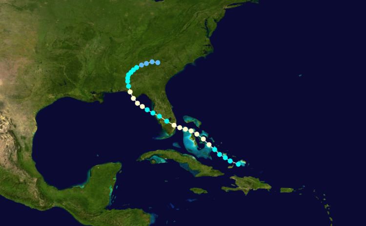
The 1903 Florida hurricane was an Atlantic hurricane that caused extensive wind and flood damage on the Florida peninsula and over the adjourning Southeastern United States in early to mid September 1903. The third tropical cyclone and third hurricane of the season, this storm was first observed near Mayaguana island in the Bahamas early on September 9. Moving northwestward, it became a hurricane the next day and passed near Nassau. The cyclone then turned to the west-northwest on September 11 and passed just north of the Bimini Islands. As it crossed the Bahamas, the cyclone produced hurricane-force winds that caused damage to crops and buildings, but no deaths were reported over the island chain.
Contents
Late on September 11, the cyclone struck near Fort Lauderdale, Florida. The Inchulva capsized near Delray Beach, drowning nine of her crew members. The cyclone caused severe wind damage in present-day Broward and Palm Beach counties, although most of the losses were to crops such as sugarcane. The cyclone weakened to a tropical storm while crossing Florida, but re-intensified into a hurricane over the Gulf of Mexico on September 17. Peaking at 90 mph (150 km/h), equivalent to a strong Category 1 hurricane on the Saffir–Simpson hurricane wind scale, the storm made landfall near Panama City early on September 14. In Northwest Florida, Alabama, and Georgia, the cyclone produced widespread rainfall, causing some crop damage. Additionally, a storm surge caused boats to be blown ashore in the Florida Panhandle. In all, the storm killed 14 people in Florida and produced $500,000 in damage. After falling to tropical storm intensity early on September 14, the storm weakened to a tropical depression on September 16, several hours before dissipating over South Carolina.
Meteorological history
Based upon scientific research conducted by the National Oceanographic and Atmospheric Administration's Hurricane Research Division in 2003, the cyclone is estimated to have first begun as a 60 mph (100 km/h) tropical storm south of Mayaguana in the Bahamas early on September 9. However, due to scarce observations, its genesis likely occurred earlier than this time but was undetected operationally. Moving slowly northwest, the cyclone quickly strengthened into a hurricane with winds of 75 mph (120 km/h), equivalent to Category 1 on the Saffir–Simpson hurricane wind scale, early the next day. By 00:00 UTC on September 11, it reached sustained winds of 85 mph (140 km/h) while centered about 15 miles (25 km) west of New Providence Island. Turning to the west-northwest, the cyclone maintained its intensity while passing just north of the Bimini Islands. Around 23:00 UTC on September 12, the cyclone struck South Florida near Fort Lauderdale with winds of 85 mph (140 km/h). Thereafter, the hurricane weakened upon crossing the Everglades, weakening to a tropical storm at 06:00 UTC on September 12.
The cyclone entered the Gulf of Mexico near Egmont Key, south of Saint Petersburg in the Tampa Bay region, with winds of 60 mph (100 km/h). At this time, the cyclone was still moving west-northwest as it had started nearly two days earlier. Although diminished in intensity after its passage over the Florida peninsula, the cyclone quickly re-organized and began to re-intensify over the Gulf of Mexico. Early on September 13, it regained hurricane intensity while centered about 100 mi (160 km) south of St. Marks in the Big Bend area of Florida. Curving to the northwest and increasing its forward speed, the hurricane peaked with maximum sustained winds of 90 mph (140 km/h) as it neared the Florida Panhandle. On the afternoon of September 13, the hurricane passed just west of Cape San Blas, but did not strike there. As its heading backed to the north-northwest, the cyclone moved made landfall near Panama City at the same intensity around 00:00 UTC on September 14. It is estimated that the storm reached peak intensity at landfall, with the peripheral pressure and storm tide observations suggesting winds of 90 mph (140 km/h), while the pressure-wind relationship indicating a minimum barometric pressure of 974 mbar (28.8 inHg). After moving inland, the cyclone rapidly diminished to a strong tropical storm and continued to weaken as it entered southern Alabama early on September 14. The next day, it turned northeast and then east-northeast, and by 00:00 UTC on September 16, it degenerated into a tropical depression. Less than 24 hours later, the system dissipated just east of the Georgia–South Carolina border.
Preparations
Between 06:00 and 12:00 UTC on September 10, the United States Weather Bureau issued storm signals, equivalent to a tropical storm warning in 2017, from Cedar Key, Florida, to Charleston, South Carolina. These were later upgraded to hurricane warnings in South Florida. Due to inclement weather conditions in West Palm Beach, which had been newly incorporated as a town just days earlier, businesses suspended their normal operations and people boarded up buildings, even as the strongest winds arrived. As the cyclone moved into the Gulf of Mexico, reports from September 12 through September 14 helped ships prepare for the storm.
Impact
In the Bahamas, the cyclone produced a barometric pressure at or below 990 mbar (29.5 inHg) on Cat Cay for about 10 hours beginning at 11:00 UTC on September 11. For a period of 30 minutes after 15:00 UTC, the pressure dropped to 976 mbar (28.82 inHg), after which hurricane-force winds decreased substantially, shifting from northeast to southwest via north, before restrengthening just after 16:00 UTC. The entire storm practically ceased by 23:00 UTC late that day. Only 0.84 inches (21.34 mm) of rain attended the passage of the hurricane on the island. On New Providence Island, Nassau recorded a pressure of 988.8 mbar (29.2 inHg) and winds of 60 mph (97 km/h) at 00:00 UTC on September 11, shortly before the anemometer blew away. Afterward, the winds shifted from east to south and were estimated to be as high as 90 mph (140 km/h). On the island, the hurricane destroyed the fruit crop and caused considerable damage to small structures. The storm also caused heavy damage to local shipping.
In southeast Florida, no wind or pressure observations were available within 50 mi (80 km) of the location where the eye of the cyclone struck the coast. However, the cyclone did produce a storm surge up to 8 feet (2.4 m) at Jupiter, which was near the radius of maximum wind, then estimated to be about 50 mi (80 km), and reported peak sustained winds of 84 mph (135 km/h). Winds of damaging force extended 30 mi (48 km) north of Jupiter, and the preponderance of the damage was limited to areas south of that settlement. Only pineapple sheds were damaged at Jupiter. About 9 mi (14 km) south, the schooner Martha T. Thomas blown ashore, without loss of crew members.
In West Palm Beach, as northeast winds reached their peak between 21:00 UTC on September 11 and 01:00 UTC the next day, parts of buildings blew away. Many buildings were unroofed, while rainfall and winds subsequently caused further damage to the interiors, such as at The Tropical Sun office building, the Seminole Hotel, the Palms Hotel, Schmid's Commercial Hotel, and properties owned by former mayor Marion E. Gruber. Several other businesses suffered similar damage. Much debris, including roofing materials, branches, paper, and driftwood, was thrown into the streets. In the African American section of the town, several buildings were destroyed. Just one of the four churches stood after the hurricane. Damage there ran "way up in the thousands."
Hotels on the nearby island of Palm Beach survived, but many coconut palms and other vegetation were prostrated. On the west shoreline of Lake Worth Lagoon, homes were swept off their foundations and their interiors flooded. Coconut trees and shrubbery were also toppled on Munyon Island. All three of the cottages were blown into the Lake Worth Lagoon, while the hotel also suffered some damage. The Lake Worth News building in Lake Worth was severely damaged by flooding. Destruction in Boynton Beach was "almost indescribable." Dozens of homes were damaged to some degree. The ground was "literally covered" with fruit, including guava, lemons, and lime, while pineapple fields were flattened. Power and telegraph lines and trees, including many large pine trees, were toppled throughout the city. Offshore, a Standard Oil barge was beached against a reef; the crew of eleven men were forced to swim ashore.
The settlements of Pompano, where the eye was believed to have come ashore, and Delray Beach were nearly destroyed, with trees defoliated and many buildings dismantled. Offshore Delray Beach, the British steamship Inchulva, wrecked near the Orange Grove House of Refuge. Nine crew members aboard the Inchulva drowned as she stranded just 200 yards (180 m) off the beach. The wreck was later salvaged and transformed into an underwater diving attraction. Damage in the Miami area was mainly confined to small buildings overturned, trees uprooted, smokestacks downed, metal awnings broken, and metal roofs scattered. Only two or three homes were blown off their foundations in the northern part of the area. At the new building for The Miami Metropolis, the wall on the west side collapsed. Telegraph and electrical lines were downed throughout the city, leaving the streets "a tangle of wires." The loss of electricity was restored by the night of September 12. Damage in South Florida reached $100,000, mainly to crops such as sugarcane in the Everglades.
In Central Florida, the cyclone only caused minor damage to structures and blew down trees, but at least two people died in Tampa. The storm also damaged businesses in the area and reportedly blew down half the local orange crop. Heavy rainfall occurred along the path, peaking at 11.40 in (289.56 mm) at Fort Meade. In the Florida Panhandle, the hurricane produced a pressure of 984.8 mbar (29.08 inHg) and winds up to 80 mph (130 km/h) at St. Andrews settlement, near Panama City. The peak storm surge was measured at up to 10 ft (3.0 m) in the town of Apalachicola. Up to 50% of the cotton crop was destroyed, but overall structural damage was minor, though ships were grounded near Apalachicola. As the cyclone moved inland over Alabama and Georgia on September 14 and 15, it produced widespread rains peaking at 5.42 in (140 mm) at Griffin, Georgia. Minor crop damage occurred in low-lying areas, but advance warning reduced the potential damage. In all, the hurricane killed 14 people, all in Florida.