
Elevation 947 m Area 200 km² Period Holocene | Last eruption 1564 | |
 | ||
Similar Pico da Vara, Dom João de Castro Bank, Mount Adagdak, Berutarube, Capelinhos | ||
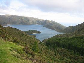
Água de Pau Massif is a stratovolcanic complex, located in central part of the island of São Miguel, in the Portuguese archipelago of the Azores. More recognizable for the Lagoa do Fogo at its centre, the volcanic complex includes centuries of geomorphological structures that include lava domes, cones and encrusted lava flows that have marked its history from, the last, 45,000 years BC.
Contents
Map of %C3%81gua de Pau, Portugal
History
The outer caldera dates from between 30,000 and 45,000 years ago, and comprises an area 4 kilometres (2.5 mi) wide and 13 kilometres (8.1 mi) long outer caldera (corresponding to the Água de Pau Massif). The inner caldera, which is 2.5 kilometres (1.6 mi) wide and 3 kilometres (1.9 mi) long was formed about 15,000 years ago. It is the younger inner caldera that is partially filled by the crater lake Lagoa do Fogo.
Until about 5000 years ago, activity in the caldera created several lava domes on the northern and western flanks.
Some of the cinder cones on these flanks are marked by radial and concentric fissures and have been active within the last 5000 years. The region has been marked by five large eruptions, which included sub aerial events 1563, 1564 and 1652. The 1563 eruption, for example was characterized by a hydromagnetic event in the interior of the caldera, which was followed four days later by an effusive eruption, while the 1564 was an explosive hydromagmatic event.
Owing to the existence of hot springs along the northwest flank, particular in the so name Caldeiras da Ribeira Grande and Caldeira Velha, the region has been used in the generation of geothermal energy or as therapeutic tourist spas.
Geography
Situated in the central part of the island, Água de Pau corresponds to a central volcanic complex and caldera that includes a large lake, punctuated by lava domes and a pumice cone. On the flanks of the massif is the Ribeira Grande Graben, a tectonic structure oriented northwest-southeast, in addition to other regional fractures and radial faults that formed other scoria and pumice cones, or lava domes.
The stratigraphy of the Água de Pau Massif is complex, caused by a diverse volcanic activity over a period dated to 200,000 years. The history of its geological features is divided into two groups.
Among the various deposits Fogo A, which dates to roughly 5000 years, corresponds a clear stratigraphy of the island of São Miguel. The flanks of the massif are heavily eroded, with drainage confined to many valleys and gullies.