
Parent range Alps | Elevation 3,774 m (12,382 ft) Country Italy | |
 | ||
Mountains Similar Alps, Ötztal, Wildspitze, Stubai Alps, Similaun | ||
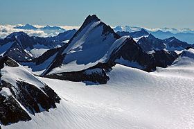
The Ötztal Alps (Italian: Alpi Venoste, German: Ötztaler Alpen) are a mountain range in the Central Eastern Alps, in the State of Tyrol in southern Austria and the Province of South Tyrol in northern Italy.
Contents
Map of %C3%96tztal Alps, 6458, Italy
GeographyEdit
The Ötztal Alps are arrayed at the head of the Ötztal valley, a side valley of the Inn river southwest of Innsbruck, Austria. One line of summits forms part of the border between Austria and Italy.
The Ötztal Alps are bordered by the Reschen Pass (1504 m) in the west and the Inn river in the northwest and north. In the east the range is separated from the Stubai Alps by the Ötztaler Ache in the Ötztal, the Timmelsjoch (2474 m) and the Passer river in the Passeier Valley. On the south and southwest, the range is limited by the deep valley of the Etsch river, here known as the Vinschgau.
In September 1991, Ötzi the so-called "Iceman" was found on the Hauslabjoch between the peaks Fineilspitze and Similaun.
PeaksEdit
The highest point of the Ötztal Alps is Wildspitze 3,774 metres (12,382 ft), which is also the second highest mountain in Austria (after Großglockner). Wildspitze is on one of several arms that extend north and northeast from the main ridge.
Some of the main peaks of the Ötztal Alps are:
PassesEdit
The main mountain passes of the Ötztal Alps are: