
Listing Ultra Easiest route basic snow climb First ascent 1848 | Elevation 3,770 m Prominence 2,261 m Parent range Ötztal Alps | |
 | ||
Similar Weißkugel, Similaun, Hinterer Brunnenkogel, Hinterer Brochkogel, Grossglockner | ||
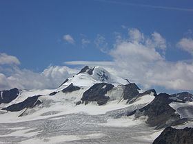
Wildspitze ( [ˈvɪltˌʃpɪʦə]) is the highest mountain in the Ötztal Alps and in North Tyrol, as well as the second highest mountain in Austria after the Großglockner. The nearest higher mountain is the Ortler, 48.5 kilometres (30 mi) away in South Tyrol.
Contents
- Map of Wildspitze 6458 Austria
- LocationEdit
- Early ascentsEdit
- RoutesEdit
- In popular cultureEdit
- References
Map of Wildspitze, 6458, Austria
LocationEdit
Wildspitze is on a ridge called Weißkamm ("white ridge") that joins the main chain of the Alps at the Weißkugel. Its north and west flanks form the end of the Pitz valley, while the south and east flanks rise above the upper ends of the Ötztal. The mountain has twin peaks, with a rocky south summit (3768 m or by most other sources 3770 m) and a firn-covered north summit that is ca 3,765 m. The mountain is surrounded by glaciers on three sides, of which with 8 km² the Taschachferner is the largest. The 50° north face is popular with ice climbers.
The lookout from the peak is only limited by the curvature of the earth. To the east one can see as far as the Großglockner and to the west as far as the Finsteraarhorn.
Early ascentsEdit
The first recorded attempt at the Wildspitze was made in 1847 by Hermann and Adolf Schlagintweit, who probably reached a point at 3,552 m on the north east ridge. The first successful ascent was in 1848 by Leander Klotz, a guide and farmer in the Rofen valley at the foot of the mountain (now part of Sölden), and another, unnamed local farmer. In August 1857, the brothers Nikodem, Leander and Hans Klotz guided Joseph Anton Specht, a merchant from Vienna, to the summit for the second ascent. The northern summit was somewhat higher, at the time measured to be 11,947 Viennese feet or 3,776 m, but the south summit was a better viewpoint and the first two parties had climbed it instead. On August 29, 1861, Nikodem and Leander Klotz guided Anthon von Ruthner and Friedrich R. von Enderes, both from Vienna, to the south summit again. During their hour-long stay on top, Leander traversed to the north peak, which subsequently was considered the first ascent of the main summit of the Wildspitze. However, by the end of the 20th century, snow melt had lowered the northern summit to about 3,765 m, rendering the south summit the highest point and 1848 the year of first ascent.
RoutesEdit
The most common route to the top is from the Breslauer Hut, which is approached from the village Vent (1900 m a.s.l.). Most climbers sleep at the hut or in a tent and continue to the summit the next day (about 4 hours from the Breslauerhütte).
An alternative route goes from the Braunschweiger Hut in the Pitztaler glacier area. From the hut the route crosses the glaciers to the Mittelbergjoch, and then traverses a crevasse-filled area of the Tasachferner glacier to the summit of the Wildspitze. The average time used for this tour is 6.5 hours.
In popular cultureEdit
Wildspitze appears in the video for German Neue Deutsche Härte band's Rammstein song Ohne dich.