
Administrative center selo of Yermakovskoye Rural localities 28 Founded 25 May 1925 | selsoviet 14 Area 17,652 km² | |
 | ||
Municipally incorporated as | ||
Yermakovsky District (Russian: Ермако́вский райо́н) is an administrative and municipal district (raion), one of the forty-three in Krasnoyarsk Krai, Russia. It is located in the south of the krai and borders with Karatuzsky District in the northeast, the Tuva Republic in the east and south, and with Shushensky District in the west and northwest. The area of the district is 17,652 square kilometers (6,815 sq mi). Its administrative center is the rural locality (a selo) of Yermakovskoye. Population: 20,918 (2010 Census); 23,202 (2002 Census); 23,043 (1989 Census). The population of Yermakovskoye accounts for 40.9% of the district's total population.
Contents
Map of Yermakovsky District, Krasnoyarsk Krai, Russia
Geography
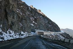
Most of the district's territory is located in the center of the Western Sayan Mountains.
History
The district was founded on May 25, 1925.
Government
As of 2013, the Head of the District and the Chairman of the District Council is Vladimir G. Yuryev. As of 2010, the District Council consists of twenty-one deputies.