
 | ||
Similar Ergaki, Mönkh Saridag, Lake Baikal, Kuznetsk Alatau, Stolby Nature Sanctuary | ||
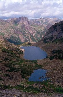
The Sayan Mountains (Russian: Саяны Sayany; Mongolian: Соёны нуруу, Soyonī nurú; Kogmen Mountains during the period of the Göktürks) are a mountain range in southern Siberia, Russia (the Tyva Republic specifically) and northern Mongolia. In the past, it served as the border between Mongolia and Russia.
Contents
- Map of Sayan Mountains Tuva Russia 668540
- Geography
- The Ice Age in the Eastern Sayan Mountains and the Southern Trans Baikal Mountains in Southern Siberia
- Origins of reindeer husbandry
- Science
- References
Map of Sayan Mountains, Tuva, Russia, 668540
The Eastern Sayan extends 1,000 km (621 mi) from the Yenisei River at 92° E to the southwest end of Lake Baikal at 106° E. The Western Sayan forms the eastern continuation of the Altay Mountains, stretching for 500 km (311 mi) from 89° E to the middle of the Eastern Sayan at 96° E.
The Sayan Mountains' towering peaks and cool lakes southwest of Tuva give rise to the tributaries that merge to become one of Siberia's major rivers, the Yenisei River, which flows north over 2000 miles to the Arctic Ocean. This is a protected and isolated area, having been kept closed by the Soviet Union since 1944.
Geography
While the general elevation is 2000 to 2,700 m (8,858 ft), granites and metamorphic slates reach altitudes of over 3,000 m (9,843 ft), with the highest being Mönkh Saridag at 3,492 m (11,457 ft). The principal mountain passes lie 1800 to 2,300 m (7,546 ft) above the sea, for example Muztagh pass at 2,280 m (7,480 ft), Mongol pass at 1,980 m (6,496 ft), Tenghyz pass at 2,280 m (7,480 ft) and Obo-sarym pass at 1,860 m (6,102 ft).
At 92°E the system (the Western Sayan) is pierced by the Ulug-Khem (Russian: Улуг-Хем) or Upper Yenisei River, and at 106°, at its eastern extremity, it terminates above the depression of the Selenga-Orkhon Valley. From the Mongolian plateau the ascent is on the whole gentle, but from the plains of Siberia it is much steeper, despite the fact that the range is masked by a broad belt of subsidiary ranges of an Alpine character, e.g. the Usinsk, Oya, Tunka and Kitoi ranges.
Between the breach of the Yenisei and Lake Khövsgöl at 100° 30' E. the system bears also the name of Yerghik-taiga. The flora is on the whole poor, although the higher regions carry good forests of larch, pine, juniper, birch, and alder, with rhododendrons and species of Berberis and Ribes. Lichens and mosses clothe many of the boulders that are scattered over the upper slopes.
The Ice Age in the Eastern Sayan Mountains and the Southern Trans-Baikal Mountains in Southern Siberia
In this area that currently shows only small cirque glaciers, at glacial times glaciers have flowed down from the 3492 m high Munku Sardyk massif situated west of Lake Baikal and from the 12.100 km² extended completely glaciated granite-gneiss plateau (2300 m asl) of the East-Sayan mountains as well as the east-connected 2600 – 3110 m-high summits in the Tunkinskaya Dolina valley, joining to a c. 30 km-wide parent glacier. Its glacier tongue that flowed down to the east, to Lake Baikal, came to an end at 500 m asl (51°48’28.98”N/103°0’29.86”E). The Khamar Daban mountains were covered by a large-scale ice cap filling up the valley relief. From its valley heads, e.g. the upper Slujanka valley (51°32’N/103°37’E), but also through parallel valleys like the Snirsdaja valley, outlet glaciers flowed to the north to Lake Baikal. The Snirsdaja-valley-outlet glacier has calved, among other outlet glaciers, at c. 400 m asl into Lake Baikal (51°27’N/104°51’E). The glacial (Würm ice age = Last Glacial Period = MIS 2) glacier snowline (ELA) as altitude limit between glacier feeding area and ablation zone has run in these mountains between 1450 and 1250 m asl. This corresponds to a snowline depression of 1500 m against the current height of the snowline. Under the condition of a comparable precipitation ratio there might result from this a glacial depression of the average annual temperature of 7.5 to 9 °C for the Last Ice Age against today.
Origins of reindeer husbandry
According to Sev’yan I. Vainshtein Sayan reindeer herding "is the oldest form of reindeer herding" and is associated with the "earliest domestication of the reindeer by the Samoyedic taiga population" of the Sayan Mountains at the "turn of the first millenium A.D... The Sayan region was apparently the origin of the economic and cultural complex of reindeer hunters-herdsmen that we now see among the various Evenki groups and the peoples of the Sayan area." The Sayan ethnic groups still live almost exclusively in the area of the Eastern Sayan mountains.
Science
The Sayan Solar Observatory is located in these mountains (51°37′18″N 100°55′07″E) at an altitude of 2,000 meters.