
- elevation 1,776 ft (541 m) Length 173 km Basin area 1,722 km² Source Shaokatan Township | - elevation 869 ft (265 m) Discharge 4.021 m³/s Basin area 1,722 km² | |
 | ||
- right South Branch Yellow Medicine River Mouths Minnesota River, Upper Sioux Agency State Park | ||
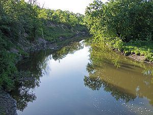
Kayaking the yellow medicine river
The Yellow Medicine River is a tributary of the Minnesota River, 107 miles (173 km) long, in southwestern Minnesota in the United States. Via the Minnesota River, it is part of the watershed of the Mississippi River, draining an area of 665 square miles (1,722 km²) in an agricultural region. Its name is a translation of the Dakota name for the river, pajutazee, ("huta" meaning "root," "zi" meaning "yellow," and "kapi" meaning "they dig"),
Contents
- Kayaking the yellow medicine river
- Map of Yellow Medicine River Sioux Agency Township MN USA
- Yellow medicine river mn avi
- Flow rateEdit
- References
Map of Yellow Medicine River, Sioux Agency Township, MN, USA
The Yellow Medicine River issues from Lake Shaokatan in Shaokatan Township in western Lincoln County, approximately six miles (10 km) southwest of Ivanhoe, on the Coteau des Prairies, a morainic plateau dividing the Mississippi and Missouri River watersheds. It flows initially northeastwardly as an intermittent stream, past Ivanhoe. The stream flows off the Coteau in northeastern Lincoln County, dropping 250 feet (75 m) in five miles (8 km), and turns east-northeastwardly, following a generally treeless course on till plains through northern Lyon County and eastern Yellow Medicine County, past Hanley Falls. It flows into the Minnesota River in Upper Sioux Agency State Park in Sioux Agency Township, approximately eight miles (13 km) southeast of Granite Falls, after dropping 85 feet (30 m) in its final ten miles (15 km) in the Minnesota River valley.
The Yellow Medicine River's largest tributaries are the North Branch Yellow Medicine River and the South Branch Yellow Medicine River, both of which flow for most of their lengths on the Coteau. The North Branch, 41 miles (66 km) long, flows northeastwardly through northern Lincoln County, briefly entering Yellow Medicine County and passing through Porter. The South Branch, 62 miles (99 km) long, flows northeastwardly through Lincoln County into northwestern Lyon County, past Minneota. Other tributaries of the Yellow Medicine include Spring Creek, 46 miles (74 km) long, which flows eastwardly through Yellow Medicine County; and Mud Creek, 31 miles (50 km) long, which flows eastwardly through western Yellow Medicine County into northwestern Lyon County.
The Minnesota Pollution Control Agency statistically combines the watershed of the Yellow Medicine River with that of Hawk Creek on the opposite bank of the Minnesota River, as well as small watersheds of nearby Minnesota River tributaries. According to the agency, 81% of the land in the Yellow Medicine-Hawk Creek watersheds is used for agriculture, with corn and soybeans being the predominant crops.
Species of fish in the Yellow Medicine River include catfish, carp, northern pike, walleye, and bullhead.
Yellow medicine river mn avi
Flow rateEdit
At the United States Geological Survey's stream gauge near Granite Falls, 6 miles (10 km) upstream from the river's mouth, the annual mean flow of the river between 1931 and 2005 was 142 cubic feet per second (4 m³/s). The highest recorded flow during the period was 17,200 ft³/s (487 m³/s) on April 10, 1969. Readings of zero were recorded on numerous days during several years.