
Source elevation 360 m | Length 62 km | |
 | ||
Yarrowitch River, a perennial stream of the Macleay River catchment, is located in the Northern Tablelands district of New South Wales, Australia.
Contents
Map of Yarrowitch River, Yarrowitch NSW, Australia
Course and features
Yarrowitch River rises within Mummel Gulf National Park on the northern slopes of the Great Dividing Range southwest of Yarrowitch, and flows generally north northeast, joined by the Warnes River before reaching its confluence with the Apsley River, southwest of Tia. The river descends 822 metres (2,697 ft) over its 62 kilometres (39 mi) course; spilling over the Yarrowitch Falls in the Oxley Wild Rivers National Park.
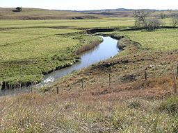
In its middle reaches, the Yarrowitch River passes through rich grazing country used for rearing livestock, principally beef cattle.
References
Yarrowitch River Wikipedia(Text) CC BY-SA