
Country Elevation 585 m Population 11,359 (Dec 31, 2008) Area 21.1 km2 | District Bern-Mittelland Mayor Gemeindeprasident | |
Worb is a municipality in the Bern-Mittelland administrative district in the canton of Bern in Switzerland.
Contents
- Map of Worb
- History
- Beautiful Switzerland Countryside Train Seat View from Bern to Worb HD Toshiba H30 review
- Geography
- Economy
- References
Map of Worb
History
Worb is first mentioned around 1130-46 as Worw.
The oldest traces of settlements in the area include scattered neolithic artificats, Hallstatt grave mounds in the Buchliwald and a La Tene cemetery at Rohrmoos-Stockeren. Other prehistoric graves have been found in the Gschneitwald. A Roman estate from the 2nd and 3rd centuries and a Roman grave have also been discovered. During the Early Middle Ages there was a small settlement that had a cemetery at Vielbringen.
The Freiherr de Worvo was first mentioned in 1127, a couple of years before the village appeared in the record. By the second half of the 13th century the Freiherr von Kien had inherited village, lands and Worb Castle. The family ruled over the Worb Herrschaft until 1336 when they became citizens of Bern and the territory came under Bernese authority. Over the following centuries several Bernese noble families ruled over the land and divided and recombined the Herrschaft. The lord over the village and Herrschaft held the Zwing und Bann and low court rights. The high court was in Konolfingen. In 1469 a fight broke out between the Bernese appointed court representative and the bailiff of Worb. It took two years for the rights and jurisdiction of both positions to be settled.
Beautiful Switzerland Countryside Train Seat View from Bern to Worb HD Toshiba H30 review
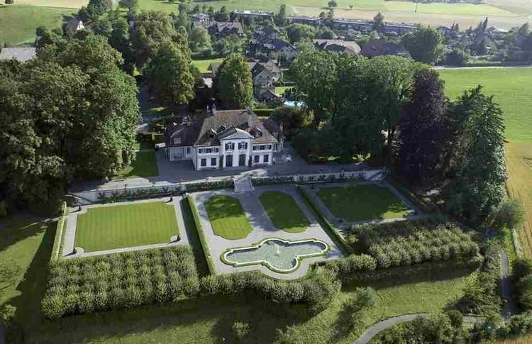
The core of Worb Castle was built before 1130. Initially it had a keep, great hall and a knights house. In 1469 and again in 1594 it was renovated and repaired. In 1643 a new residential wing was added to the castle. A new ornate manor house was built near the old castle in 1734 by Christoph von Graffenried. This new estate was known as Neuworb but was also called the Neuschloss or New Castle. The two estates were acquired by the Goumoens-Sinner family in 1846. In 1964 the Seelhofer family bought the old castle while the New Castle was bought in 1985 by the von Graffenried family. Another country estate was built in 1730 in the village of Richigen for the Stettler family. Later Richigen Manor passed from the Stettlers to the von Wattenwyl family and then to the Dollfus von Volckersberg family.
The first village church was probably a wooden structure built during the Early Middle Ages. The wooden building was probably replaced with a stone one at a later date. In the 11th century the Church of Saint Maurice was built above the early medieval tombs of the earlier churches. The church bell tower was built some time after 1430. In the third quarter of the 15th century murals were painted on the walls. The current choir and choir windows were added to the building in 1520-21. After Worb adopted the Protestant Reformation in 1528, the church converted to the new faith and the old parish of Worb was divided into four sections. The Reformed church remained the only church in the village until 1953 when the Catholic church of St. Martin was built in Worb. It was rebuilt in 1998 to its current appearance.
While farming was generally important in Worb, in 1380 the Freiherr of Kien diverted the Biglenbach stream from Walkringen to Worb. They built a mill along the stream and over the following centuries forges, sawmills, grain mills, dyers, taverns and inns developed in the village. In 1804 a hammer mill was built along the Biglenbach and industry began to develop in Worb. After 1900 there were numerous factories built along the stream and in the village.
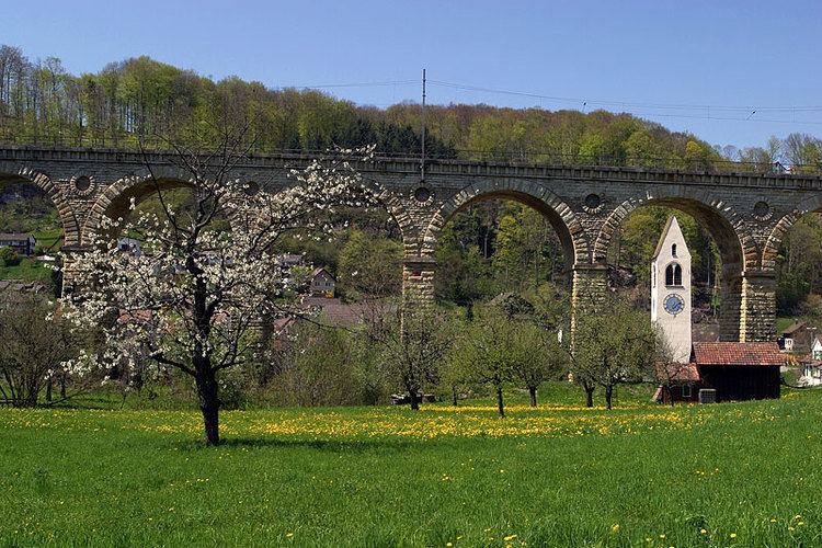
The first railroad station of the Bern-Lucerne railroad opened in 1859 on the outskirts of the municipality. This remained the only railroad station until 1898 then the Bern-Worb railroad entered the center of the village. The Worblentalbahn line was built in 1913 and connected Worb with the neighboring municipalities. The two rail lines merged in 1927 and provided an efficient link between Worb and its neighbors. The rail lines combined with excellent roads have allowed many commuters to settle in Worb. In the later half of the 20th century many of the older factories were replaced with new industries including; industrial electronics, equipment construction, furniture and interior design. In 2012, the main employers in the municipality were various transportation companies, HVAC factories and the timber industry.
The municipality is home to a total of ten schools as of 2012.
Geography
Worb has an area of 21.1 km2 (8.15 sq mi). As of 2012, a total of 13.18 km2 (5.09 sq mi) or 62.5% is used for agricultural purposes, while 4.42 km2 (1.71 sq mi) or 20.9% is forested. Of the rest of the land, 3.29 km2 (1.27 sq mi) or 15.6% is settled (buildings or roads), 0.07 km2 (17 acres) or 0.3% is either rivers or lakes and 0.04 km2 (9.9 acres) or 0.2% is unproductive land.
During the same year, industrial buildings made up 1.2% of the total area while housing and buildings made up 9.3% and transportation infrastructure made up 3.8%. Out of the forested land, all of the forested land area is covered with heavy forests. Of the agricultural land, 46.1% is used for growing crops and 13.8% is pastures, while 2.6% is used for orchards or vine crops. All the water in the municipality is flowing water.
The municipality is located in the upper Worblen valley. It consists of the villages and hamlets of Worb, Rufenacht, Vielbringen, Enggistein, Richigen, Ried, Wattenwil and Bangerten.
On 31 December 2009 Amtsbezirk Konolfingen, the municipalitys former district, was dissolved. On the following day, 1 January 2010, it joined the newly created Verwaltungskreis Bern-Mittelland.
Economy
As of 2011, Worb had an unemployment rate of 2.09%. As of 2008, there were a total of 3,432 people employed in the municipality. Of these, there were 275 people employed in the primary economic sector and about 99 businesses involved in this sector. 933 people were employed in the secondary sector and there were 106 businesses in this sector. 2,224 people were employed in the tertiary sector, with 327 businesses in this sector. There were 6,015 residents of the municipality who were employed in some capacity, of which females made up 44.9% of the workforce.