
 | ||
The m v confederation car ferry arriving in wood islands prince edward island
Wood Islands is a rural farming and fishing community located in southeastern Queens County, Prince Edward Island on the Northumberland Strait. It takes its name from several small forested islands, then located several hundred metres offshore in the Northumberland Strait. The community of Wood Islands falls within the larger PEI Township of Lot 62, which had a population in 2011 of 470 residents, a 13% decrease from the 2006 census count of 540. While the named islands are located on maps by Jacques-Nicolas Bellin: Karte Bellin, 1744: ‘I a Bova’ and Louis Franquet: Cartes Franquet, 1751: ‘Isle a Bois’, it was Samuel Johannes Holland who correctly surveyed and depicted the islands, about their basin. The 'European' settlement of Wood Islands began in 1803, but saw its most noted arrivals in 1807 with the arrival, after wintering in Pinette, of a large party of Scottish settlers from The Spencer.
Contents
- The m v confederation car ferry arriving in wood islands prince edward island
- Map of Wood Islands PE Canada
- The Harbour and The LighthouseEdit
- The PEI Railroad and The Murray Harbour SubdivisionEdit
- The Northumberland Ferries Limited and The Wood Islands ServiceEdit
- The Wood Islands and Area Development Corporation and The Wood Islands Welcome CentreEdit
- References
Map of Wood Islands, PE, Canada
The Harbour and The LighthouseEdit
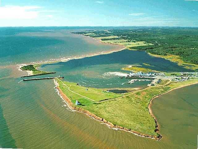
Wood Islands Harbour. Previously denoted as Victoria Harbour - c1868, depicted on Franquet, 1751, and as it appears on Jeffreys, 1775; their works denote a natural harbour that has long played an noted role in the island’s history. Of then three islands, they are now permanently linked by sand bars to form the Harbour. A 'winter mail run' operated between Wood Islands and Pictou, Nova Scotia, initiated in 1777, was the first 'official' island’s winter seasonal connection to the mainland, until 1827. Today, it is a sheltered harbour hosting a ferry service to Caribou, Nova Scotia, operated by Northumberland Ferries Limited, as well as small craft fishing vessels. The southwestern shore of the lagoon forming Wood Islands Harbour is also the southernmost point in Prince Edward Island with coordinates 45º65'54"N, 62º45'18"W. Wood Islands Harbour in Prince Edward Island is at latitude 45.953 and longitude -62.7478. It is designated a ‘Core Fishing Harbour’ – noted as critical to fishing and aquaculture industries, and it is now being managed by Harbour Authority of Wood Islands.
Wood Islands Lighthouse. During its session of 1874, the Canadian Parliament appropriated $6,000 for a lighthouse at Wood Islands, as an aid of marine traffic in the Strait and for fishers in and around Wood Islands harbour. A contract for $3,000 was entered into with Archibald McKay of Moncton, NB, who abandoned the project after having received $900 for his work. The Department of Marine hired Donald MacMillian to complete the work; the then eight-room structure was finished during the autumn of 1876 and put into operation on 1 November 1876. Allen, 1880 and Cummins, 1927 show the light on the south bank of an island, in the Wood Islands basin, adjacent to the then harbour entrance breakwaters. The southeast island came to be attached to shore with changes in the harbour usage, and with the construction of the Wood Islands ferry terminal and berthing docks. It is the second oldest lighthouse, with an attached dwelling and tower of this style, on the island. The difficult approach meant that the keepers had few visitors before the present road was built in the late 1930s. The Wood Islands Lighthouse is now a museum operated by a local community group and can be toured daily from mid-July to mid-September.
The PEI Railroad and The Murray Harbour SubdivisionEdit
The Prince Edward Island Railway (Mark PEIR c1875 - 1989) was originally set out to cross the Island only from Alberton (then Cascumpec) to Georgetown, thought it quickly added its two subdivisions, one up to Tignish from Alberton and a second east into Souris from Mount Stewart. The ‘initial’ system of 198.5 miles was ‘complete’ by January 1875, and by 1880, with additional short spurs, there were two trains daily crossing the province, one eastbound and one westbound.
In 1905, the federal government funded the PEIR to build a new line, a subdivision, from east of Charlottetown, out to Murray Harbour. Part of which saw the construction of the ’new’ Hillsborough River Bridge, consisting of 12 sections of two 'surplus’ narrow gauge rail bridges, to support the Murray Harbour Subdivision, bringing service to southeastern corner of the Island. Under superintendent, Benjamin MacEachern, of Hopefield, on November 1, 1905, of 52.3 miles in length, with the Hillsborough Bridge completed, it fully opened for traffic, the daily run taking a scheduled 3 hours and 35 minutes.
The commission to build the Murray Harbour Subdivision went to D.R. Morrison of Summerside, PE, a relative newcomer to the Island construction scene, assisted by contractors: Willard Kitchen Construction Company of Grand Falls, NB, R.E Mutch and Company of Charlottetown, PE and M.F. Schurman and Company of Kensington, PE. Started on 17 May 1900, with setting out and grade work, its first rails arrived at Belle River on 18 October 1901, with station construction beginning in 1903. Missing a vital link, it began limited runs on 26 September 1905, the Branch terminating at Southport, passengers used a ferry to cross to Charlottetown, for a short period before the Hillsborough Bridge was completed.
Set out to minimize large cuttings, large fills, and to avoid the need for bridges, the Murray Harbour Subdivision consisted of twenty-two stops: initially 9, then 13, booking stations and nine flag stations. The Booking Stations, in design, had a pleasing construction and arrangement, with a freight shed and sometimes with detached facilities. The Flag Stations over time changed from being ‘Open Ended Sheds’ to ‘Closed In Sheds’ - with single or double doors and windows. In addition to the stations, there were two water tanks and a full engine house - it located in Murray Harbour.
In Lot 62 there were three PEIR stations: first, initially a flag station, at Belle River (on the Alex Stewart acreage, above the Douses Road), the second a booking station, in Wood Islands, and the third, another flag station, in Iris / Pleasant Valley (on the Hurd acreage, on the Murray Road). After looping around the Belle River weir and its headwater, the Wood Islands 'Booking' Station was located on the southwest corner of the crossing of the Montague - Wood Islands Road. Just below the junction of the Pleasant Valley / Wood Islands and Montague Roads, the Station also housed the Wood Island (North) Post Office, the Station Agent also being the Postmaster.
From 1989, when the trains stopped running, there eventually developed an opportunity for a rail trail or recreational trail to be set out crossing the Island. The CN trail corridor purchased in 1994, by the provincial government, sees the Confederation Trail, completed in 2014, again connecting rural PEI. In Wood Islands, from just east of the ‘old’ Wood Islands Station - south to the Wood Islands Welcome Centre runs a 4.1 km nature trail 'spur'. Built by a group of dedicated community volunteers, the spur ends at a replica PEIR Booking Station, much like the one that sat beside Wood Island and Montague Road, with the original freight shed that once sat beside the old PEIR Belle River Station.
The Northumberland Ferries Limited and The Wood Islands ServiceEdit
Ever since the federal government established a subsidized ferry service in 1917 between Borden, PEI and Cape Tormentine, NB under Crown corporation Canadian National Railways, residents of eastern Prince Edward Island had lobbied their elected representatives for an alternative service to Pictou, Nova Scotia; the Borden - Cape Tormentine ferry having replaced a government steamship service between Georgetown and Pictou.
In 1935, Prime Minister MacKenzie King brought Saskatchewan politician Charles A. Dunning back into federal politics to economically resurrect the nation from the Great Depression and appointed him Minister of Finance. Dunning was elected by acclamation as a parachute candidate in the dual riding of Queen's (it had 2 MPs at the time). Residents seized upon this opportunity and elicited a promise from the King government to establish a ferry service from southeastern PEI to Caribou, NS, near the town of Pictou.
The location of the PEI terminal was a source of controversy as the deepest water on the PEI shore suitable for a ferry dock was located just east of the Kings County boundary in Little Sands, Prince Edward Island, several kilometres east of Wood Islands. However, given that Dunning represented the riding of Queen's, the Little Sands location was rejected in favour of a terminal located at Wood Islands, to better help the residents of his electoral district, despite its inferior water depth.
The federal government set about building a ferry port in the community's small harbour, dredging sand from the harbour bottom and constructing wharves. A new privately owned company, Northumberland Ferries Limited, was established to manage and operate the seasonal ferry service under license for the federal government, which retained ownership of the terminals, real property and vessels.
Dunning left politics in 1939 but the ferry service was instituted nevertheless in 1941 and has continued uninterrupted under the NFL banner to the present day, using several used and new vessels over the decades. Today it remains the only ferry service to the mainland after Confederation Bridge opened in 1997. A major redevelopment of the Wood Islands terminal took place in the early 1990s before the new high capacity M/V Confederation entered service in 1993. The federal government continues providing financial assistance to NFL under the terms of a contribution agreement, while the company leases two ferry terminals and vessels from the federal government. Today, though seasonal, it remains the only ferry service to the mainland.
The Wood Islands and Area Development Corporation and The Wood Islands Welcome CentreEdit
In 2002 Premier Binns opened a provincial Visitor Information Centre at the intersection of Route 1 and Route 4, located one-half kilometre from the Wood Islands ferry terminal, to welcome the more than 350,000 ferry passengers travel through Wood Islands each year. Then with a corporate Liquor Control Commission retail outlet, the new centre also incorporated a community room, two rental shops and a seasonal museum, which became the responsibility of the Wood Islands and Area Development Corporation. Today, the corporation now manages the highly popular Wood Islands Lighthouse (c1876) and a commercial interest in a seasonal PEI LCC Agency Store. As The PEI Gateway East - The Wood Islands Welcome Centre, welcoming all seasonal visitors, allows all visitors the opportunity to learn more about the history and the opportunities of eastern PEI. The Wood Islands - Welcome Centre and Eastern PEI are home to the 70-Mile Coastal Yard Sale held in September each year.