
GNIS feature ID 0204665 Elevation 2,130 m Population 15 (2010) | Time zone MST (UTC-7) FIPS code 08-85760 Zip code 81655 Local time Tuesday 7:07 PM | |
 | ||
Weather 1°C, Wind NW at 14 km/h, 66% Humidity Area 101 ha (96 ha Land / 5 ha Water) | ||
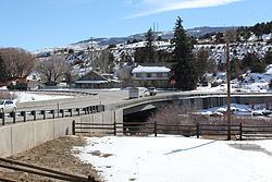
Wolcott is a census-designated place (CDP) and a U.S. Post Office located in Eagle County, Colorado, United States. The population as of the 2010 census was 15. The Wolcott Post Office has the ZIP Code 81655.
Contents
Map of Wolcott, CO 81632, USA
A post office called Wolcott has been in operation since 1889. The community was named after Edward O. Wolcott, a United States Senator from Colorado.
Geography
Wolcott is located in central Eagle County at 39°42′10″N 106°40′42″W (39.702696,-106.678448), in the valley of the Eagle River, a west-flowing tributary of the Colorado River. U.S. Route 6 passes through the community, following the river, while Interstate 70 forms the southern edge of the CDP, with access from Exit 157. I-70 and US-6 each lead 7 miles (11 km) east to Edwards and west 10 miles (16 km) to Eagle, the county seat. Colorado State Highway 131 intersects I-70 at Exit 157, passes through the center of Wolcott, and leads north 72 miles (116 km) to Steamboat Springs.