
- right Naringhil Creek - elevation 291 m (955 ft) Source Black Hill, Victoria | - elevation 114 m (374 ft) | |
 | ||
- left Mount Misery Creek, Kuruc-A-Ruc Creek Bridges McMillans Bridge, Pitfield Bridge | ||
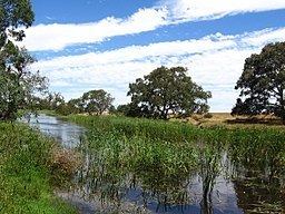
The Woady Yaloak River is a perennial river of the Corangamite catchment, located in the Western District Lakes region of the Australian state of Victoria.
Contents
Map of Woady Yaloak River, Victoria, Australia
Location and features
The Woady Yaloak River rises below Black Hill, west of Ballarat and flows generally south joined by three minor tributaries through the towns of Smythesdale, Scarsdale and Cressy before reaching its river mouth and emptying into Lake Martin and then Lake Corangamite. From its highest point, the river descends 280 metres (920 ft) over its meandering 104-kilometre (65 mi) course.
The river is crossed by the Glenelg Highway west of Scarsdale and the Hamilton Highway at Cressy, and McMillans Bridge on the Rokewood-Skipton Road between Rokewood and Werneth.
Etymology
In the Australian Aboriginal Wathawurrung language different sections of the river are given two names, Wurdi-yaluk or sometimes Wurdi-ya1uk gundidj, meaning "big creek"; and Currarerer, with no defined meaning. Variations on the spelling of the river's name have included Wandinyallock, Wardiyallock and Worriyallock.