
Length 494.6 km | ||
 | ||
Counties | ||
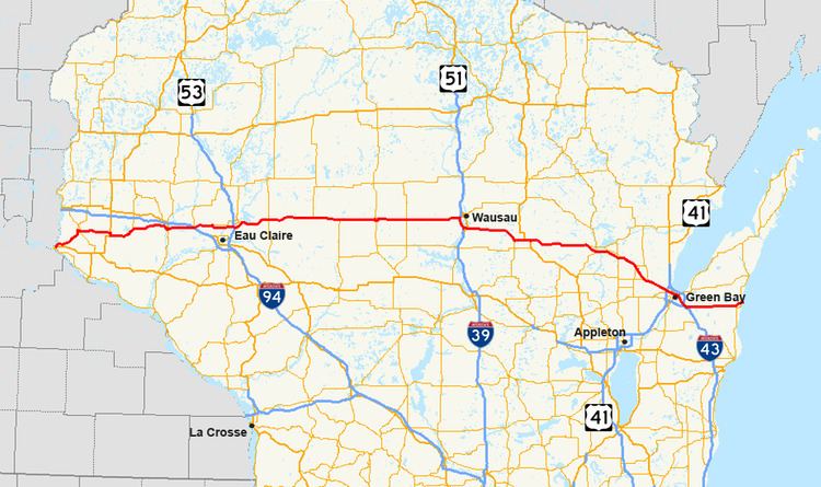
State Trunk Highway 29 (often called Highway 29, STH-29 or WIS 29) is a state highway running east–west across central Wisconsin. It is a major east–west corridor connecting the Twin Cities and the Chippewa Valley with Wausau and Green Bay. A multi-year project to upgrade the corridor to a four-lane freeway or expressway from Elk Mound to Green Bay was completed in 2005. The expansion served to improve safety on the route, which was over capacity as a two-lane road. The remainder of WIS 29 is two-lane surface road or urban multi-lane road.
Contents
Prescott to Elk Mound
WIS 29 passes through Pierce, St Croix and Dunn Counties in this section. The highway begins at its western terminus at U.S. Highway 10 (US 10), on the north side of Prescott. From this point, WIS 29 follows WIS 35 northeast to River Falls, passing the University of Wisconsin–River Falls campus. At the junction with WIS 65, WIS 35 turns northbound with WIS 65 while WIS 29 continues east. WIS 29 joins briefly with US 63 west of Spring Valley and turns eastbound upon its split one mile (1.6 km) south to head into Spring Valley. Upon leaving Spring Valley and Pierce county, the route heads northward into St Croix County and turns east towards Menomonie. WIS 29 does not pass through any municipalities while in this county, but it does cross WIS 128.
Upon entering Dunn County, the route passes through rural terrain and enters Menomonie's west side as Hudson Rd. The route turns northward onto Main street and passes west and north of the University of Wisconsin–Stout campus. WIS 29 turns east onto Stout Road along with US 12 and leaves the city to the east. The two routes proceed east for about 9 miles (14 km) and junction with Interstate 94. This interchange is the westernmost point of the multi-lane WIS 29 corridor. It is also the westernmost point of WIS 29 as a backbone route in Corridors 2020.
Elk Mound to Wausau
Between Elk Mound and Wausau, WIS 29 passes through Dunn, Chippewa, Clark and Marathon counties. West of County T, the route is an expressway. The route passes into the Chippewa Valley metropolitan area and south of Chippewa Falls as a Freeway and crosses U.S. Route 53 at a cloverleaf interchange in Lake Hallie. WIS 29 junctions with the southern terminus of WIS 178 southeast of Chippewa Falls then passes to the south of Lake Wissota State Park before crossing under WIS 27 in Cadott. WIS 29 passes south of Boyd and Stanley before exiting the county to the east.
In Clark County, WIS 29 meets WIS 73 in Thorp. The two routes exit the village to the east concurrently and WIS 73 splits to the south in Withee about 10 miles (16 km) east. WIS 29 continues east and passes south of Owen and Curtiss. At Abbotsford, WIS 29 and WIS 13 meet at a partial cloverleaf interchange between Abbotsford and Colby on the Clark and Marathon county line. Twelve miles east of Abbotsford, WIS 29 and WIS 97 meet at a diamond interchange. This is a key route for travelers between Wausau and Marshfield. East of this junction, WIS 29 follows a straight route that passes Edgar and meets WIS 107 at a diamond interchange on the north side of Marathon City, approximately 8 miles west of Wausau. WIS 29 enters Wausau as a freeway, junctions with the western terminus of WIS 52 approx. 1/2 mile west of US 51 at an eastbound off/westbound on style half-interchange. WIS 29 then immediately enters the new US 51 interchange, and turns south onto and follows US 51 for five miles (8 km), bypassing the downtown area to the south.
Wausau to Green Bay
This stretch of the highway passes through Marathon, Shawano, Outagamie and Brown Counties. South of Wausau, WIS 29 turns off US 51 to the east at the northern terminus of I-39 and continues as freeway, passing through the villages of Rothschild and Weston. The freeway section ends at Ringle. As an expressway, the highway passes just south of Hatley and turns southeast for about four miles (6 km) before turning east again at the northern terminus of WIS 49.
The highway enters Shawano County about one mile (1.6 km) east of this junction. WIS 29 passes north and around Wittenberg. US 45 joins with the highway north of Wittenberg and the two routes run concurrently to where US 45 splits to the south at about two miles (3 km) east of the village. WIS 29 bypasses Tilleda and Thornton on the way towards Shawano At Shawano, the expressway becomes a freeway at the junction with County MMM (WIS 29 Business) and turns southeast to bypass Shawano to the south, diamond interchanges link the highway with WIS 22 and WIS 47 North / WIS 55 North as it pass south of the city. WIS 47 South and WIS 55 South follow WIS 29 east. WIS 47 splits to the south at the diamond interchange junction with WIS 117 south of Bonduel. WIS 29 (along with WIS 55) then returns to an expressway at the junction with County BE (WIS 29's former route). WIS 55 splits to the south at the diamond interchange junction with WIS 160 at Angelica and WIS 29 heads southeast to its junction with WIS 156 at the Brown County line.
About one mile (1.6 km) into Brown County, WIS 29 collects WIS 32 eastbound at the diamond interchange with County Y. WIS 29 very briefly passes through the northeast corner of Outagamie County and enters the village of Howard. The multilane expressway and the Backbone Corridor route end at Interstate 41/US Highway 41 (I-41/US 41). WIS 32 turns south onto I-41/US 41 as WIS 29 continues into Green Bay as Shawano Avenue.
Green Bay to Kewaunee
This section of the highway passes through Brown and Kewaunee Counties. In downtown Green Bay, WIS 29 turns north onto South Monroe Avenue for 4 blocks, joining with WIS 54 and turns east onto Main Street, splitting from WIS 54 and joining US 141 to leave the city to the southeast. The highways passes over I-43 without an interchange. WIS 29 splits to the east from US 141 at about 1-mile (1.6 km) north of US 141's southern terminus at I-43 in Bellevue. This provides the only access from I-43 to WIS 29. The highway passes through Poland and Henrysville as it exits Brown County to the east. In Kewaunee County, WIS 29 passes due east through Pilsen and north of Krok as a two lane road. The highway ends in downtown Kewaunee at WIS 42 on the shores of Lake Michigan.
History
Prior to 1926, WIS 29 was numbered WIS 116 from Minnesota to Chippewa Falls, WIS 16 from Chippewa Falls to Bellevue, and WIS 146' from Bellevue to Kewaunee. WIS 16 continued southeast from Bellevue along what became US 141 in 1926 to Manitowoc. What had been WIS 29 before 1926 became US 16 across the state.
WIS 29 has long been known as "Bloody 29" because of the prevalence of grisly fatal traffic crashes along significant portions of the highway. In 1988, a study was commissioned to examine upgrading the highway to a 4-lane divided highway. The changes would be made along 203 miles (327 km) of road from I-94, 2 miles (3.2 km) west of Elk Mound, to US 41 in Howard (suburban Green Bay). The final segment of the highway, connecting the east side of Chippewa Falls with the segment running north of Eau Claire, was opened to traffic on August 16, 2005. Of the total length, about 65 miles (105 km) of the highway meets Interstate standards. Most of the expansion was able to be completed with only minor additions to the already-existing easements, and as a result, the expanded roadway almost exactly matches the highway's original course. While traffic crashes have declined significantly, numerous memorials to those who lost their lives on the road still dot the route.
WIS 29 is the only Wisconsin state highway in WisDOT's Corridors 2020 Backbone Routes system.
The portion of WIS 29 between Chippewa Falls and Abbotsford roughly follows what used to be the Yellowstone Trail.
In 2007, the improvements to WIS 29 won a Wonders of Wisconsin Engineering Award from the American Council of Engineering Companies, Wisconsin Chapter. Four firms (Ayres Associates, Strand Associates, CH2M Hlll and Earth Tech) were honored for their work on the project in the chapter's 50th anniversary award program.
Current status
The US 51/WIS 29 expansion project is now completed in the Wausau area. This project has expanded the portions of WIS 29 that are co-signed with US 51 from four lanes to six lanes and reconstructed interchanges along the route to allow for higher bridge clearances, and higher capacity on/off ramps. The southern interchange where WIS 29 turns east from I-39/US 51 was rebuilt from a trumpet interchange to a Y-interchange and was completed in late 2006.
The northern interchange where WIS 29 turns west off of US 51 is now fully open to traffic. It was rebuilt from a standard diamond interchange with traffic signals at the ramp terminals into a free flowing Y interchange with flyover ramps immediately south of the old interchange, which is now used for WIS 52 alone. On September 17, 2010, the final ramp connecting WIS 29 eastbound to US 51 northbound opened to traffic. Other upgrades to WIS 29 in the Wausau area include the segment from Wausau to Marathon City, where most at grade access has been removed, along with the construction of a new diamond interchange at County O. The paved center median was replaced with a concrete barrier median, and the speed limit raised to 65 mph. This project was completed in late 2013.
As part of the massive US 41 project, WIS 29 has been undergoing upgrades in Brown County, beginning at County J in the Village Of Howard, proceeding east to US 41. The new WIS 29/US 41 Interchange opened to traffic in late 2014. The original diamond interchange was replaced with a "free-flow" freeway-to-freeway Y style interchange to allow for uninterrupted travel between the two highways. The upgrades also included an interchange at County EB/Packerland Dr./Cardinal Ln and a grade separated overpass at County J. Work has also begun on upgrading WIS 29 to freeway status from Packerland Drive westerly to the Brown/Shawano County Line. In summer 2014, a brand new diamond interchange was opened along WIS 29 at County FF; the intersection of WIS 29 and Sunlite Dr/Woodland Dr was closed, and "J" turns were constructed as safety enhancements at County VV and County U until funding can be secured to construct an interchange at the former and an overpass at the later of these intersections.
Future
WisDOT is studying options for WIS 29 conversions to Interstate Highway standards in these sections:
In Dunn County, studies are now being conducted on the reconstruction of the WIS 29/I-94 interchange. The objective is to provide a free-flow interchange between the two freeways, similar to the US 51/WIS 29 interchange in Wausau, and the I-41/US 41/WIS 29 interchange in Green Bay. This will be the final link in the WIS 29 project, with direct freeway to freeway interchanges at the three major junctions along the route.
The section between I-94 and County Highway X's eastern exit is already designated as a freeway by WisDOT—despite the existence of several at-grade intersections between US 53 and I-94. WisDOT is studying options for upgrade of these intersections as part of the study. WisDOT is also studying options for upgrades to the highway to a freeway further east to Bruce Mound Avenue in Clark County.
The second section—between Wittenberg (US 45) and Green Bay (US 41) is also undergoing a study for planned upgrades of the highway to freeway standards. As it stands now, the Shawano bypass is the only section that is a freeway. The study is geared toward upgrading the rest of the section to Interstate standards. Early plans in Shawano County would see interchanges constructed at County D (Tilleda), Leopolis Road, County U, County MMM/Bus. WIS 29 (Shawano/Thornton), and County F (Zachow); as well as overpasses built at Nightengale Road west of Wittenberg, County D/Rock Road, Rangeline Road west of Thornton, Broadway Road, Main Laney Drive, and St. Augustine Road/WIS 156 at the Shawno–Brown county Line.
The third section—between Ringle (County Q) and Wittenberg (US 45) is at the preliminary stages for freeway upgrades. WisDOT is currently focusing on preserving right-of-way access for future upgrades. Early plans call for overpasses at Hilltop Road and County D; as well as an interchange at WIS 49 in eastern Marathon County.
The stretch from Wausau to Marathon City saw upgrades in 2013. Future improvements to this stretch still include an overpass at 152nd Avenue. As of December 2011, WisDOT has proposed plans for eventual freeway conversion for the segment of WIS 29 from WIS 13 easterly to WIS 107. Included is an interchange with County E, as well as overpasses at County F, County M, and County S.
Business routes
WIS 29 has four business routes: