
Population 970 (2011) Unitary authority Local time Sunday 5:00 AM | OS grid reference SO550174 Dialling code 01600 | |
 | ||
Weather 7°C, Wind NW at 8 km/h, 87% Humidity Points of interest Forest of Dean, The aMazing Hedge P, Blasmere, Wye Valley Butterfly Zoo, Whitchurch Clock Tower | ||
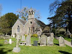
Whitchurch is a village in Herefordshire named after the church of Saint Dubricius which was originally white in colour.
Map of Whitchurch, UK
Whitchurch is situated on the A40, connecting nearby Ross-on-Wye to Welsh town Monmouth. It is located near Symonds Yat and the Doward hills, so the village is used to tourists.
Until the 9th century, when it was taken over by Mercia, this area was within the Welsh kingdom of Ergyng. After the Norman conquest, the area became known as Archenfield and was governed as part of the Welsh Marches. It became part of Herefordshire, and England, in the 16th century, although the use of Welsh in the area remained strong until the 19th century. The Welsh name for the village, Llandywynnog, means "church of Tywynnog", derived from a personal name Gwynnog.
Within the parish in Symonds Yat (West) is the Old Court (now the Old Court Hotel) which was the ancestral home of the Gwillim family including Elizabeth Posthuma Gwillim. Thomas Gwillim built the Gwillim family burial enclosure at the church in 1744. John Graves Simcoe, first Lieutenant Governor of Upper Canada (1791–1796) and founder of Toronto, named Whitchurch Township in Ontario after the birthplace of his wife, Elizabeth Gwillim.
The primary school is Whitchurch Church of England Primary School, which holds awards for Investors in People and Eco Schools.