
Type of rock Limestone | Elevation 2,962 m Country Germany | |
 | ||
Mountains Similar | ||
Hary wetterstein fritz duerauer toni griebaum pedro duarte der weudl
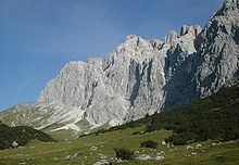
The Wetterstein mountains (German: Wettersteingebirge), also simply called the Wetterstein, is a mountain group in the Northern Limestone Alps within the Eastern Alps. It is a relatively compact range located between Garmisch-Partenkirchen, Mittenwald, Seefeld in Tirol and Ehrwald. Part of it is in the German free state of Bavaria and part in the Austrian federal state of Tyrol. The main summit of the Wetterstein, the Zugspitze, is also the highest mountain in Germany.
Contents
- Hary wetterstein fritz duerauer toni griebaum pedro duarte der weudl
- Map of Wetterstein 82467 Garmisch Partenkirchen Germany
- Vaude climbing through the wetterstein tom h ck und j rgen knappe
- Neighbouring rangesEdit
- BoundariesEdit
- SubgroupsEdit
- PeaksEdit
- FaunaEdit
- HutsEdit
- Long distance pathsEdit
- KlettersteigsEdit
- LiftsEdit
- SightsEdit
- References
Map of Wetterstein, 82467 Garmisch-Partenkirchen, Germany
The Wetterstein mountains are an ideal region for mountaineers and climbers. Mountain walkers sometimes need to allow for significant differences in elevation. The proximity of the range to the south German centres of population, the scenic landscape and its good network of cable cars and lifts mean that the mountains are heavily frequented by tourists for most of the year. There are, however, places in the Wetterstein that are rarely or never visited by people.
Vaude climbing through the wetterstein tom h ck und j rgen knappe
Neighbouring rangesEdit
The Wetterstein borders on the following other mountain ranges of the Alps:
In the AVE, the Alpine Club classification of the Eastern Alps, the Wetterstein and the Mieming range are classed as a single group.
BoundariesEdit
The River Loisach forms the boundary of the range to the west and north, from the Ehrwald Basin to Garmisch-Partenkirchen. To the northeast the boundary runs from Garmisch-Partenkirchen to Mittenwald along the Kankerbach and Kranzbach streams and the Isar river. To the east the Isar forms the boundary from Mittenwald to Scharnitz. South of Scharnitz it continues along the Drahnbach stream to Seestadeln. To the south the boundary extends from Ehrwald along the Gaisbach stream and over the Ehrwalder Alm to the Gaistal valley (Leutascher Ache) and continues via Leutasch-Oberweidach and past the Simmelberg to the north to the Drahnbach.
The saddle between the Kankerbach and the Kranzbach (the Loisach – Isar watershed) links the Wetterstein with the Bavarian Prealps. The saddle near the Ehrwalder Alm is the link between the Wetterstein and Mieming Chain.
SubgroupsEdit
The Alpine Club Guide divides the Wetterstein into the following subgroups:
PeaksEdit
The 10 highest summits of the Wetterstein are:
There are over 150 named summits in the Wetterstein with spot heights. Amongst the best known are (in order of height):
The Zugspitze is very frequently climbed using various routes and the Alpspitze summit, too, is a popular destination that can be reached on several different routes. The ridge of Jubiläumsgrat is a high alpine climbing route that links these two summits. The climbing along the Blassenkamm ridge over the tops of the Innere, Mittlere and Äußere Höllentalspitze has sections that are classified as UIAA grade III-.
The region around the Oberreintal Hut and the south side of the Schüsselkarspitze and Scharnitzspitze are well known for alpine climbing routes of all levels up the solid, limestone slabs. The south side above the Gaistal is markedly quieter than the north side.
For climbers, the mountains north of Leutasch are very interesting, especially the Oberreintal-Schrofen, the Scharnitzspitze and the Schüsselkarspitze. On the south faces of these three border mountains are alpine climbing routes aplenty. In recent years several alpine classics were renovated by Heinz Zak. This has attracted ever more climbers to the region.
FaunaEdit
The combination of alms and rugged rocky terrain is not only unique in the German Alpine region, but also offers habitats for several species of animal, such as chamois, Alpine marmots, Alpine choughs, Alpine salamanders, adders, golden eagles and many species of marten.
HutsEdit
The German Alpine Club maintains six managed Alpine Club huts in the Wetterstein mountains with overnight accommodation: the Münchner Haus (2,962 m), the Meiler Hut (2,366 m), the Knorr Hut (2,052 m), the Kreuzeckhaus (also: Adolf Zoeppritz Haus, 1,652 m), the Höllentalanger Hut (1,379 m) and the Reintalanger Hut (1,366 m). In addition, are the privately run Schachenhaus (1,866 m) and the Wiener Neustädter Hut (2,209 m, maintained by the Austrian Tourist Club) offer food, refuge and accommodation for mountaineers and hikers. The Munich Branch of the German Alpine Club has rented the Waxenstein Hut (also Alpl Hut or Aiple Hut) since 1920 and operates it as self-catered accommodation. In the Oberreintalkar lies the Oberreintal Hut, which is the meeting point for Wetterstein climbers (a self-catering hut although drinks are sold by the proprietor). In winter the Stuiben Hut is used as a self-catering hut for ski tourers and snowshoe trekkers. In addition there are several privately owned huts in the Wetterstein mountains. Of these, the Kreuzjochhaus stands out because of its idyllic setting, which offers one of the best panoramas in the Bavarian Alps in the summer and is located in the middle of the Garmisch-Partenkirchen ski region in the winter.
Long-distance pathsEdit
The Via Alpina, a cross-border long-distance path with five stages through the whole of the Alps, also runs through the Wetterstein. The Red Way of the Via Alpina (Rote Weg der Via Alpina) runs through the Wetterstein in three stages:
Stage 15 of the North Alpine long-distance path 01 (Limestone Alp Way) runs through the Wetterstein in two route variations.
From Scharnitz over the Hoher Saddle to Leutasch-Ahrn both variations are combined. In Ahrn the long-distance path forks into a high alpine and an easier variant. The high alpine variant runs via the Meiler Hut into the Reintal valley and continues to the summit of the Zugspitze. From there it descends to Ehrwald. The easier variant runs through the Leutascher Achental valley via the Ehrwalder Alm and also ends at Ehrwald.
KlettersteigsEdit
There are the following klettersteigs (sometimes abbreviated to Steig) in the Wetterstein:
LiftsEdit
Several large cable cars and lifts link to the summit regions and high skiing areas: The Bavarian Zugspitze Railway (a metre gauge rack railway from Garmisch to the Zugspitzplatt), the Eibsee Cable Car (from the Eibsee to the Zugspitzplatt), the Tyrolean Zugspitze Cable Car (from Ehrwald to the Zugspitzplatt) and the Ehrwalder Almbahn.
SightsEdit
Those not interested in a climbing tour or multi-day summit tour, can hike the Partnach Gorge, the Leutasch Gorge or the Höllental Gorge in a day.