
 | ||
The Westphalian Lowland, also known as the Westphalian Basin is a flat landscape that mainly lies within the German region of Westphalia, although small areas also fall within North Rhine (in the extreme southwest) and in Lower Saxony (on the northern periphery). Together with the neighbouring Lower Rhine Plain to the west, it represents the second most southerly region of the North German Plain, after the Cologne Bight. It is variously known in German as the Westfälische Bucht (Westphalian Bay), the Münsterländer or Westfälische Tieflands- or Flachlandsbucht (Münsterland or Westphalian Lowland or Plain).
Contents
The Westphalian Lowland consists of the individual regions of Münsterland, the Emscherland in the (western) south, and regions even further south that flank the Sauerland around the Hellweg.
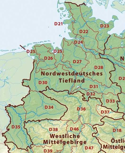
The Westphalian Lowland is classified as a major unit group within the natural regions of Germany and is number 54 in the Handbook of the Natural Regional Divisions of Germany (Handbuch der naturräumlichen Gliederung Deutschlands) and region D34 in the BfN system; both using the same boundaries.
Natural region divisions
From a natural region perspective the Westphalian Lowland major unit group is sub-divided into the following three-figure major units:
Location
The Westphalian Lowland has the character of a basin because it is bounded by ridges of the Lower Saxon Hills from the northeast to east and by the northern part of the Süder Uplands to the south. These hills rise to heights of several hundred metres above the basin floor.
The boundary of this natural region runs, clockwise from the north, as follows: From Rheine southeastwards along the southern edge of the Teutoburg Forest, from southwest of Osnabrück heading southwest of Bielefeld to the point where the Teutoburg Forest meets the Eggegebirge. From here the boundary runs to the Paderborn Plateau in front of the Egge heading south-southwest via Paderborn and Büren.
From east of Rüthen its boundary with the North Sauerland Oberland (including the Arnsberg Forest Nature Park) runs in a westerly direction, passing the Möhnesee immediately south of the Haarstrang and then runs south of the Hellweg to the edge of the Lower Sauerland to south of Dortmund, from where its course takes it further west, north of the Ardey Hills and the adjoining parts of the Lower Berg-Mark Hills (Niederbergisch-Märkisches Hügelland) heading south of Bochum and Essen to the vicinity of Mülheim.
From east of Mülheim its unremarkable boundary with the Lower Rhine Plain runs northwards via Bottrop, Dorsten, Borken and finally along the state border with the Netherlands, to Gronau.
Towns and cities
The largest centres of population in the Westphalian Lowland are the cities of the central and eastern Ruhrgebiet north of the River Ruhr in the southwest of the region and the cities of Münster in the centre, Gütersloh in the north and Paderborn on the eastern periphery. The city of Bielefeld itself lies outside the region over the other side of the Teutoburg Forest, however parts of the borough lies within the northern part of the basin (Brackwede, Senne, Sennestadt).
The most populous cities in the Westphalian Lowland are (in brackets their population in thousands):
Rivers
The most important river systems are:
Meaning
The area is occasionally called in German, the Münsterländische Bucht (Münsterland Bay), because a large part of this low-lying plain lies in central and eastern Münsterland. It is therefore used pars pro toto for the whole region.
The use of the term Bucht ("bay" or "bight") stems from the geological origin of the region which is half surrounded by the ridges of the Central Uplands. At one time it formed a bay in the coastline of the Cretaceous Sea the shape of which can be discerned from the topography.
Population
The majority of the population of the Westphalian Lowland live in the area bordering the southern perimeter, in the region of the historic Hellweg east-west trade route through Germany, and especially in the northern Ruhr.
Palaeontology
At various sites in the Westphalian Lowland giant ammonites have been found in Cretaceous layers of rock below the surface, for example when the underground railway network was being built in Dortmund. These cephalopods, with a shell diameter of more than two metres are the largest known invertebrates.