Founded by Dhirubhai Ambani Time zone IST (UTC+5:30) Area 129 km² | Lok Sabha constituency West Delhi Elevation 219 m | |
 | ||
Colleges and Universities Pearl Academy, Shivaji College, Rajdhani College, Shyama Prasad Mukherji, Bharati Vidyapeeth's College o Points of interest Rock Garden, Herbal Garden, Fun Villa, Dilli Chalo Museum, District Park | ||
West Delhi (Hindi: वेस्ट दिल्ली) is an administrative district of the National Capital Territory of Delhi in India.
Contents
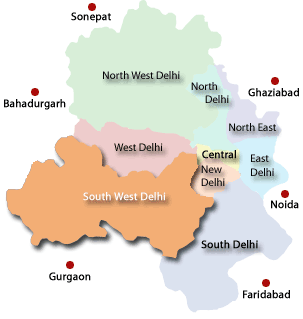
Map of West Delhi, Delhi
West Delhi is bound by the districts of North West Delhi to the north, North Delhi and Central Delhi to the east, South West Delhi to the south, and Jhajjar District of Haryana state to the west.
West Delhi has an area of 129 km², with a population density of nearly 14,000 persons per km². The population of 1,743,980 consists of 949,750 males and 794,230 females. Children between 0–6 years are 203,528 consisting of 109,526 boys and 94,002 girls. The literacy rate is above 70% at a total of 1,301,252 of which 739,572 are males and 561,680 females.
Administratively, the district is divided into three subdivisions, Patel Nagar, Rajouri Garden, and Punjabi Bagh. Major residential and commercial areas of Delhi like Janakpuri and Tilak Nagar are located in West Delhi.
Demographics
According to the 2011 census West Delhi has a population of 2,531,583, roughly equal to the nation of Kuwait or the US state of Nevada. This gives it a ranking of 169th in India (out of a total of 640). The district has a population density of 19,625 inhabitants per square kilometre (50,830/sq mi) . Its population growth rate over the decade 2001-2011 was 18.91%. West Delhi has a sex ratio of 876 females for every 1000 males, and a literacy rate of 87.12%.
