
Country United States Elevation 3 m Local time Friday 5:32 PM | Incorporated April 17, 1884 Zip code 08204 Population 1,020 (2013) | |
 | ||
Area rank 487th of 566 in state14th of 16 in county Weather 11°C, Wind SE at 34 km/h, 97% Humidity | ||
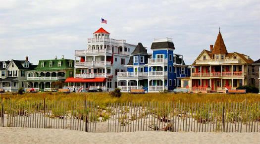
West Cape May is a Walsh Act borough in Cape May County, New Jersey, United States. It is part of the Ocean City Metropolitan Statistical Area. As of the 2010 United States Census, the borough's population was 1,024, reflecting a decline of 71 (-6.5%) from the 1,095 counted in the 2000 Census, which had in turn increased by 69 (+6.7%) from the 1,026 counted in the 1990 Census.
Contents
- Map of West Cape May NJ 08204 USA
- History
- Historic sites
- Geography
- Census 2010
- Census 2000
- Local government
- Federal state and county representation
- Politics
- Education
- Roads and highways
- Public transportation
- Wineries
- References
Map of West Cape May, NJ 08204, USA
West Cape May was incorporated as a borough by an act of the New Jersey Legislature on April 17, 1884, from portions of Lower Township, based on the results of a referendum held two days earlier. The borough was reincorporated on April 11, 1890, and again on May 4, 1897. The borough's name derives from Cape May, which was named for 1620 Dutch captain named Cornelius Jacobsen May who explored and charted the area between 1611–1614, and established a claim for the province of New Netherland.
During Hurricane Sandy in October 2012, West Cape May was hit by 9.53 inches (242 mm) of rain, the most of any place in the state.
It is a no longer a dry town, after the Board of Commissioners approved the sale of a liquor license for more than $600,000 to a store that opened in May 2012. In 2008, voters approved a referendum that allowed the issuance of a single license for retail liquor sales and another for sale of alcoholic beverages at a restaurant. The borough had been dry for 128 years, where alcohol cannot be sold, affirmed by the results of a referendum held in 1940, joining Cape May Point, Ocean City and Wildwood Crest among municipalities in Cape May restricting the sale of alcohol.
History
The borough's history goes back to the time of the Lenape Native Americans and several buildings date to the Colonial period. The area has a rich agricultural history which continues to be celebrated each year with a summer farmers' market, and strawberry, tomato and lima bean festivals. It has been known as the "Lima Bean Capital of the World." The Lima Bean Festival is an annual event held in West Cape May, New Jersey, the "Lima Bean Capital of the World", and is the world's only such celebration. It is held annually on the Saturday of Columbus Day weekend in Wilbraham Park.
West Cape May, once known as Eldredge, is one of the four jurisdictions that comprise Cape Island in Cape May County. West Cape May was incorporated as a borough by an act of the New Jersey Legislature on April 17, 1884, from portions of Lower Township, based on the results of a referendum held two days earlier. The borough was reincorporated on April 11, 1890, and again on May 4, 1897.
The Borough has reported ties to the Underground Railroad.
From 1881 to 1931, the Hastings Goldbeating Company was located in the Borough employing women to pound one-inch strips of gold into gossamer-thin sheets used for decorative arts. Women still did the "booking" of gold leaf sheets until 1961. A plaque indicating the location of the factory can be found on Goldbeaten Alley. It was this business, along with real estate speculation and subdivision of the land, that led to the Borough's incorporation in 1884.
Historic sites
The historic core of the Borough was placed on the National Register of Historic Places along with sections of the City of Cape May in 1976.
Whilldin-Miller House was added to the National Register of Historic Places on February 12, 2003. The original timber frame two-story house remaining in the rear was built by Joseph Whilldin about 1715, while the front portion of the house was built in 1860, making it one of the oldest remaining houses on Cape Island.
Geography
According to the United States Census Bureau, the borough had a total area of 1.175 square miles (3.044 km2), including 1.165 square miles (3.018 km2) of land and 0.010 square miles (0.026 km2) of water (0.86%).
The borough borders the Cape May County municipalities of Lower Township and Cape May City
Census 2010
The 2010 United States Census counted 1,024 people, 493 households, and 293.8 families residing in the borough. The population density was 878.8 per square mile (339.3/km2). The borough contained 1,043 housing units at an average density of 895.1 per square mile (345.6/km2). The racial makeup of the borough was 85.84% (879) White, 8.69% (89) Black or African American, 0.78% (8) Native American, 0.20% (2) Asian, 0.00% (0) Pacific Islander, 3.13% (32) from other races, and 1.37% (14) from two or more races. Hispanics or Latinos of any race were 4.98% (51) of the population.
Out of a total of 493 households, 14.0% had children under the age of 18 living with them, 46.0% were married couples living together, 10.3% had a female householder with no husband present, and 40.4% were non-families. 36.3% of all households were made up of individuals, and 17.2% had someone living alone who was 65 years of age or older. The average household size was 2.08 and the average family size was 2.66.
In the borough, 12.8% of the population were under the age of 18, 6.1% from 18 to 24, 13.5% from 25 to 44, 39.2% from 45 to 64, and 28.5% who were 65 years of age or older. The median age was 55.0 years. For every 100 females the census counted 93.2 males, but for 100 females at least 18 years old, it was 88.0 males.
The Census Bureau's 2006-2010 American Community Survey showed that (in 2010 inflation-adjusted dollars) median household income was $48,281 (with a margin of error of +/- $6,924) and the median family income was $51,394 (+/- $3,176). Males had a median income of $42,361 (+/- $10,529) versus $43,860 (+/- $3,583) for females. The per capita income for the borough was $34,328 (+/- $4,010). About 8.4% of families and 6.7% of the population were below the poverty line, including 8.0% of those under age 18 and 4.8% of those age 65 or over.
Census 2000
As of the 2000 United States Census there were 1,095 people, 507 households, and 302 families residing in the borough. The population density was 923.5 people per square mile (355.3/km2). There were 1,004 housing units at an average density of 846.8 per square mile (325.8/km2). The racial makeup of the borough was 84.11% White, 14.52% African American, 0.37% Native American, 0.55% from other races, and 0.46% from two or more races. Hispanic or Latino of any race were 1.83% of the population.
There were 507 households out of which 21.1% had children under the age of 18 living with them, 44.2% were married couples living together, 11.2% had a female householder with no husband present, and 40.4% were non-families. 35.1% of all households were made up of individuals and 17.4% had someone living alone who was 65 years of age or older. The average household size was 2.16 and the average family size was 2.80.
In the borough the population was spread out with 19.6% under the age of 18, 3.6% from 18 to 24, 23.7% from 25 to 44, 28.7% from 45 to 64, and 24.4% who were 65 years of age or older. The median age was 46 years. For every 100 females there were 92.8 males. For every 100 females age 18 and over, there were 88.4 males.
The median income for a household in the borough was $37,500, and the median income for a family was $47,031. Males had a median income of $36,375 versus $29,583 for females. The per capita income for the borough was $25,663. About 4.7% of families and 7.4% of the population were below the poverty line, including 6.3% of those under age 18 and 8.9% of those age 65 or over.
Local government
The Borough of West Cape May has operated under the Walsh Act Commission form of government since 1948. The Board of Commissioners consists of three members, who are elected at-large in non-partisan elections held as part of the November general election and serve four-year, concurrent terms of office. Once the Commissioners take office, they divide up responsibility for the municipal departments, with each Commissioner serving as a Department Director and holds all the executive, administrative, judicial and legislative powers, with no single chief executive. An ordinance adopted by the Board of Commissioners in December 2012 shifted the borough's municipal elections from May to November.
As of 2016, the borough's commissioners are Mayor Pamela M. Kaithern (Commissioner of Revenue and Finance), Deputy Mayor Peter C. Burke (Commissioner of Public Works, Parks and Public Property) and Carol E. Sabo (Commissioner of Public Affairs and Public Safety), who are all serving terms of office that end December 31, 2017.
Sabo was appointed in early 2013 to fill the vacant seat of Ramsay Geyer, who had resigned to move out of the borough. Kaithern, Burke and Sabo were all re-elected in November 2013.
Federal, state and county representation
West Cape May is located in the 2nd Congressional District and is part of New Jersey's 1st state legislative district.
New Jersey's Second Congressional District is represented by Frank LoBiondo (R, Ventnor City). New Jersey is represented in the United States Senate by Cory Booker (D, Newark, term ends 2021) and Bob Menendez (D, Paramus, 2019).
For the 2016–2017 session (Senate, General Assembly), the 1st Legislative District of the New Jersey Legislature is represented in the State Senate by Jeff Van Drew (D, Dennis Township) and in the General Assembly by Bob Andrzejczak (D, Middle Township) and R. Bruce Land (D, Vineland). The Governor of New Jersey is Chris Christie (R, Mendham Township). The Lieutenant Governor of New Jersey is Kim Guadagno (R, Monmouth Beach).
Cape May County is governed by a Board of Chosen Freeholders consisting of five members, elected at-large in partisan elections to three-year terms of office on a staggered basis, with one or two seats coming up for election each year; At an annual reorganization held each January, the freeholders select one member to serve as Director and another to serve as Vice-Director. As of 2015, Cape May County's Freeholders are Freeholder Director Gerald M. Thornton (Middle Township, term ends December 31, 2016), Freeholder Vice-Director Leonard C. Desiderio (Sea Isle City, 2015), Kristine Gabor (Upper Township, 2017), E. Marie Hayes (Ocean City, 2016), and Will Morey (Wildwood Crest, 2017). The county's constitutional officers are Sheriff Gary Schafer (Middle Township, 2017), Surrogate M. Susan Sheppard (Ocean City, 2017), and County Clerk Rita Fulginiti (Ocean City, 2015).
Politics
As of March 23, 2011, there were a total of 776 registered voters in West Cape May, of which 249 (32.1%) were registered as Democrats, 284 (36.6%) were registered as Republicans and 241 (31.1%) were registered as Unaffiliated. There were 2 voters registered to other parties.
In the 2012 presidential election, Democrat Barack Obama received 61.0% of the vote (385 cast), ahead of Republican Mitt Romney with 37.2% (235 votes), and other candidates with 1.7% (11 votes), among the 640 ballots cast by the borough's 830 registered voters (9 ballots were spoiled), for a turnout of 77.1%. In the 2008 presidential election, Democrat Barack Obama received 62.9% of the vote (387 cast), ahead of Republican John McCain, who received 35.0% (215 votes), with 615 ballots cast among the borough's 752 registered voters, for a turnout of 81.8%. In the 2004 presidential election, Democrat John Kerry received 60.5% of the vote (377 ballots cast), outpolling Republican George W. Bush, who received around 38.5% (240 votes), with 623 ballots cast among the borough's 818 registered voters, for a turnout percentage of 76.2.
In the 2013 gubernatorial election, Republican Chris Christie received 59.8% of the vote (329 cast), ahead of Democrat Barbara Buono with 37.6% (207 votes), and other candidates with 2.5% (14 votes), among the 582 ballots cast by the borough's 816 registered voters (32 ballots were spoiled), for a turnout of 71.3%. In the 2009 gubernatorial election, Democrat Jon Corzine received 52.2% of the vote (245 ballots cast), ahead of both Republican Chris Christie with 39.0% (183 votes) and Independent Chris Daggett with 6.0% (28 votes), with 469 ballots cast among the borough's 778 registered voters, yielding a 60.3% turnout.
Education
The West Cape May School District serves students in pre-kindergarten through sixth grade at West Cape May Elementary School. As of the 2012-13 school year, the district and its one school had a total enrollment of 66 students and 6.6 classroom teachers (on an FTE basis), for a student–teacher ratio of 9.62:1, making it one of the districts with the smallest enrollment in the state.
For seventh through twelfth grades, public school students attend the schools of the Lower Cape May Regional School District, which serves students from Cape May, Lower Township and West Cape May, along with students from Cape May Point who attend as part of a sending/receiving relationship. Schools in the district (with 2014-15 enrollment data from the National Center for Education Statistics) are Richard M. Teitelman Middle School (grades 7 and 8; 524 students) and Lower Cape May Regional High School (9-12; 905).
In 2013, the Lower Cape May Regional School District received a feasibility study that looked at ways to reconfigure the district, which had been established in 1956. The study considered Cape May City withdrawing from the regional district or the dissolution of the district, converting Lower Township's existing PreK-6 district to serve PreK-12, as the regional district's school facilities are located in the township. Cape May City and West Cape May could see annual savings approaching a combined $6 million from the dissolution.
Roads and highways
As of May 2010, the borough had a total of 11.87 miles (19.10 km) of roadways, of which 8.82 miles (14.19 km) were maintained by the municipality and 3.05 miles (4.91 km) by Cape May County.
Public transportation
NJ Transit offers bus service between Cape May and Atlantic City on the 552 route.