
Country United States Named for Cornelius Jacobsen Mey Local time Wednesday 12:55 PM | Founded 1611–1614 Zip code 08204 | |
 | ||
Incorporated March 8, 1848, as Cape Island Borough Reincorporated March 10, 1851, as Cape Island City Reincorporated March 9, 1869, as Cape May City Weather 13°C, Wind W at 19 km/h, 48% Humidity Points of interest Emlen Physick Estate, Cape May County Park & Zoo, Naval Air Station Wildwood, Sunset Beach, Cape May Lighthouse | ||
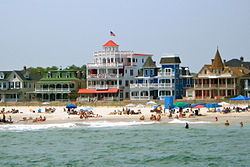
931 beach guest house in cape may new jersey
Cape May is a city at the southern tip of Cape May Peninsula in Cape May County, New Jersey, where the Delaware Bay meets the Atlantic Ocean. One of the country's oldest vacation resort destinations, it is part of the Ocean City Metropolitan Statistical Area. As of the 2010 United States Census, the city had a year-round population of 3,607, reflecting a decline of 427 (-10.6%) from the 4,034 counted in the 2000 Census, which had in turn declined by 634 (-13.6%) from the 4,668 counted in the 1990 Census. In the summer, Cape May's population is expanded by as many as 40,000 to 50,000 visitors. The entire city of Cape May is designated the Cape May Historic District, a National Historic Landmark due to its concentration of Victorian buildings.
Contents
- 931 beach guest house in cape may new jersey
- Map of Cape May NJ 08204 USA
- HistoryEdit
- US Navy support during World War IIEdit
- GeographyEdit
- ClimateEdit
- 2010 CensusEdit
- 2000 CensusEdit
- EconomyEdit
- Arts and cultureEdit
- Fishermans MemorialEdit
- Local governmentEdit
- Federal state and county representationEdit
- PoliticsEdit
- EducationEdit
- Roads and highwaysEdit
- Public transportationEdit
- MediaEdit
- Coast Guard Training Center Cape MayEdit
- In popular cultureEdit
- Notable peopleEdit
- References
Map of Cape May, NJ 08204, USA
With a rich history, award-winning beaches, designation as a top birdwatching location, and many examples of Victorian architecture, Cape May is a seaside resort drawing visitors from around the world. Cape May was recognized as one of America's top 10 beaches by the Travel Channel and its beach was ranked fifth in New Jersey in the 2008 Top 10 Beaches Contest sponsored by the New Jersey Marine Sciences Consortium.
HistoryEdit
The city was named for 1620 Dutch captain Cornelius Jacobsen Mey who explored and charted the area between 1611–1614, and established a claim for the province of New Netherland. It was later settled by New Englanders from the New Haven Colony.
What is now Cape May was originally formed as the borough of Cape Island by an act of the New Jersey Legislature on March 8, 1848, from portions of Lower Township. It was reincorporated as Cape Island City on March 10, 1851, and finally became Cape May City as of March 9, 1869.
Cape May began hosting vacationers from Philadelphia in the mid 18th century and is recognized as the country's oldest seaside resort. It became increasingly popular in the 18th century and was considered one of the finest resorts in America by the 19th century. In 1878 a five-day-long fire destroyed square blocks of the town center and as part of the reconstruction efforts replacement homes were almost uniformly of Victorian style. As a result of this and of more recent preservation efforts, Cape May is noted for its large number of well-maintained Victorian houses — the second largest collection of such homes in the nation after San Francisco. In 1976, the entire city of Cape May was officially designated a National Historic Landmark as the Cape May Historic District, making Cape May the only city in the United States wholly designated as such. That designation is intended to ensure the architectural preservation of these buildings.
U.S. Navy support during World War IIEdit
Because of the World War II submarine threat off the East Coast of the United States, especially off the shore of Cape May and at the mouth of the Delaware Bay, numerous United States Navy facilities were located here in order to protect American coastal shipping. Cape May Naval facilities, listed below, provided significant help in reducing the number of ships and crew members lost at sea.
GeographyEdit
According to the United States Census Bureau, the city had a total area of 2.743 square miles (7.103 km2), including 2.404 square miles (6.226 km2) of land and 0.339 square miles (0.877 km2) of water (12.35%). Cape May is generally low-lying; its highest point, at the intersection of Washington and Jackson Streets, is 14 feet (4.3 m) above sea level.
Unincorporated communities, localities and place names located partially or completely within the city include Poverty Beach.
Cape May borders West Cape May Borough, Lower Township, the Atlantic Ocean, and the Delaware Bay. The Cape May-Lewes Ferry provides transportation across the Delaware Bay to Lewes, Delaware.
Cape May Harbor, which borders Lower Township and nearby Wildwood Crest allows fishing vessels to enter from the Atlantic Ocean, was created as of 1911, after years of dredging completed the harbor which covers 500 acres (200 ha). Cape May Harbor Fest celebrates life in and around the harbor, with the 2011 event commemorating the 100th anniversary of the harbor's creation.
Cape May is the southernmost point in New Jersey; it is at approximately the same latitude as Washington, D.C.
ClimateEdit
According to the Köppen climate classification system, Cape May has a humid subtropical climate (Cfa), typical of coastal New Jersey, with hot, humid summers and cool winters.
Precipitation is distributed fairly evenly throughout the year. Being the southernmost point in New Jersey, Cape May has fairly mild wintertime temperatures, with a January daily average temperature of 35.1 °F (1.7 °C). Conversely, summer sees less extreme heat than in most places in the state, making the town a popular place to escape the heat; on average there are only 12 days of 90 °F (32 °C)+ temperatures. Snowfall averages 15.7 inches (39.9 cm) per season, mostly from December to February. Extremes in temperature have ranged from −2 °F (−19 °C) on January 17, 1982 up to 106 °F (41 °C) on July 7, 1966; since 1894, sub-0 °F (−18 °C) have occurred only four times and 100 °F (38 °C)+ only seven times.
Cape May is in USDA hardiness zone 7b/8a, similar to parts of coastal Maryland, making it a suitable location to grow traditional northeastern plants including English yew, boxwoods, and sugar maples. Because of the warmer wintertime temperatures, Hardy Palms including Trachycarpus fortunei (Chinese Windmill Palm) and Needle Palms work quite well in the landscape. Wine grapes also do particularly well, given the long growing season.
2010 CensusEdit
The 2010 United States Census counted 3,607 people, 1,457 households, and 782.4 families residing in the city. The population density was 1,500.6 per square mile (579.4/km2). The city contained 4,155 housing units at an average density of 1,728.5 per square mile (667.4/km2). The racial makeup of the city was 89.05% (3,212) White, 4.85% (175) Black or African American, 0.30% (11) Native American, 0.67% (24) Asian, 0.11% (4) Pacific Islander, 2.30% (83) from other races, and 2.72% (98) from two or more races. Hispanics or Latinos of any race were 8.62% (311) of the population.
Out of a total of 1,457 households, 16.3% had children under the age of 18 living with them, 44.6% were married couples living together, 7.5% had a female householder with no husband present, and 46.3% were non-families. 42.0% of all households were made up of individuals, and 27.9% had someone living alone who was 65 years of age or older. The average household size was 1.95 and the average family size was 2.64.
In the city, 12.8% of the population were under the age of 18, 20.6% from 18 to 24, 18.6% from 25 to 44, 20.3% from 45 to 64, and 27.6% who were 65 years of age or older. The median age was 42.2 years. For every 100 females the census counted 104.7 males, but for 100 females at least 18 years old, it was 107.4 males.
The Census Bureau's 2006-2010 American Community Survey showed that (in 2010 inflation-adjusted dollars) median household income was $35,660 (with a margin of error of +/- $4,248) and the median family income was $50,846 (+/- $16,315). Males had a median income of $43,015 (+/- $20,953) versus $31,630 (+/- $22,691) for females. The per capita income for the city was $30,046 (+/- $4,010). About 2.2% of families and 4.8% of the population were below the poverty line, including 5.1% of those under age 18 and 7.1% of those age 65 or over.
2000 CensusEdit
As of the 2000 United States Census there were 4,034 people, 1,821 households, and 1,034 families residing in the city. The population density was 1,623.7 people per square mile (628.0/km2). There were 4,064 housing units at an average density of 1,635.7 per square mile (632.7/km2). The racial makeup of the city was 91.32% White, 5.26% African American, 0.20% Native American, 0.40% Asian, 0.05% Pacific Islander, 1.26% from other races, and 1.51% from two or more races. Hispanic or Latino of any race were 3.79% of the population.
There were 1,821 households out of which 18.0% had children under the age of 18 living with them, 47.6% were married couples living together, 7.0% had a female householder with no husband present, and 43.2% were non-families. 39.4% of all households were made up of individuals and 24.2% had someone living alone who was 65 years of age or older. The average household size was 2.02 and the average family size was 2.69.
In the city the population was spread out with 16.3% under the age of 18, 11.5% from 18 to 24, 19.8% from 25 to 44, 23.9% from 45 to 64, and 28.5% who were 65 years of age or older. The median age was 47 years. For every 100 females there were 97.1 males. For every 100 females age 18 and over, there were 94.5 males.
The median income for a household in the city was $33,462, and the median income for a family was $46,250. Males had a median income of $29,194 versus $25,842 for females. The per capita income for the city was $29,902. About 7.7% of families and 9.1% of the population were below the poverty line, including 7.0% of those under age 18 and 10.9% of those age 65 or over.
EconomyEdit
Tourism is the dominant industry. Cape May's economy runs on shops, restaurants, lodgings and tourist attractions on Washington Street Mall, along the boardwalk and elsewhere throughout town. Many historic hotels and B&Bs dot the landscape. Commercial and sport fishing are also important to Cape May's economy. The Cove Beach host each day to hundreds of swimmers, sunbathers, surfers,and hikers. Located at the very south west end of town, with a totally unobstructed view each day of the sunset Marine mammal watching, bird watching, and other forms of eco-tourism have become equally important. A small wine growing area is adjacent to Cape May and tours of several wineries are available.
For a period of several decades before 2010, French Canadian tourists visited Cape May during the summer. Cape May County established a tourism office in Montreal, Quebec, but around 1995 it closed due to budget cuts. By 2010 the tourism office of Cape May County established a French language coupon booklet.
Arts and cultureEdit
Cape May has become known both for its Victorian gingerbread homes and its cultural offerings. The town hosts the Cape May Jazz Festival, the Cape May Music Festival and the Cape May, New Jersey Film Festival. Cape May Stage, an Equity theater founded in 1988, performs at the Robert Shackleton Playhouse on the corner of Bank and Lafayette Streets. East Lynne Theater Company, an Equity professional company specializing in American classics and world premieres, has its mainstage season from June–December and March, with school residencies throughout the year. Cape May is home to the Mid-Atlantic Center for the Arts & Humanities (MAC), established in 1970 by volunteers who succeeded in saving the 1879 Emlen Physick Estate from demolition. MAC offers a wide variety of tours, activities and events throughout the year for residents and visitors and operates three Cape May area historic sites—the 1879 Emlen Physick Estate, the Cape May Lighthouse and the World War II Lookout Tower. The Center for Community Arts (CCA) offers African American history tours of Cape May, arts programs for young people and is transforming the historic Franklin Street School, constructed in 1928 to house African-American students in a segregated school, into a Community Cultural Center.
Cape May is the home of the so-called "Cape May Diamonds". They show up at Sunset Beach and other beaches in the area. These are in fact clear quartz pebbles that wash down from the Delaware River. They begin as prismatic quartz (including the color sub-varieties such as Smoky Quartz and Amethyst) in the quartz veins alongside the Delaware River that get eroded out of the host rock and wash down 200 miles to the shore. Collecting Cape May diamonds is a popular pastime and many tourist shops sell them polished or even as faceted stones.
The Cape May area is also world-famous for the observation of migrating birds, especially in the fall. With over 400 bird species having been recorded in this area by hundreds of local birders, Cape May is arguably the top bird-watching area in the entire Northeastern United States. The Cape May Bird Observatory is based nearby at Cape May Point.
Cape May is also a destination for marine mammal watching. Several species of whales and dolphins can be seen in the waters of the Delaware Bay and Atlantic Ocean, many within 10 miles (16 km) of land, due to the confluence of fresh and saltwater that make for a nutrient rich area for marine life. Whale and dolphin watching cruises are a year-round attraction in Cape May, part of an ecotourism / agritourism industry that generated $450 million in revenue in the county, the most of any in the state.
Fisherman's MemorialEdit
The Cape May Fisherman's Memorial, at Baltimore and Missouri Avenues, was erected in 1988. It consists of a circular plaza reminiscent of a giant compass, a granite statue of a mother and two small children looking out to Harbor Cove, and a granite monument listing the names of 75 local fishermen who died at sea. The names begin with Andrew Jeffers, who died in 1893, and include the six people who died in March 2009 with the sinking of the scalloping boat Lady Mary. The granite statue was designed by Heather Baird with Jerry Lynch. The memorial is maintained by the City of Cape May and administered by the Friends of the Cape May Fisherman's Memorial. Visitors often leave a stone or seashell on the statue's base in tribute to the fishermen.
Local governmentEdit
Effective July 1, 2004, the City of Cape May switched to a Council-Manager form of government under the Faulkner Act, after having used Plan A of the Faulkner Act Small Municipality form since 1995. The governing body consists of a Mayor and a Borough Council comprising four council members, with all positions elected at large in non-partisan elections. A Mayor is elected directly by the voters to a four-year term of office. The Borough Council is elected to serve four-year terms on a staggered basis, with three seats coming up for election and then the mayor and the fourth seat two years later. Following the 2004 elections, the first under the new form of government, lots were drawn to determine which of the newly elected members would serve a four-year term, with the other three serving two-year terms. A city manager is responsible for the city's executive functions, managing Cape May's activities and operation. Voters approved a November 2010 referendum to shift the city's elections from May to November, with city officials estimating that the change would save $30,000 in costs associated with each May election.
As of 2017, the Mayor of Cape May City is Clarence F. Lear III, whose term of office ends December 31, 2020. Other members of the Cape May City Council are Deputy Mayor Shaine P. Meier (2018), Roger Furlin (2018; elected to serve an unexpired term), Beatrice Gauvry-Pessagno (2018) and Patricia Gray Hendricks (2020).
in March 2015, Councilman Jerry Inderweis resigned to protest what he called a "witch hunt" against the police chief. In the November 2015 general election, Roger Furlin was elected to fill the balance of the council seat vacated by Inderwies.
Federal, state and county representationEdit
Cape May City is located in the 2nd Congressional District and is part of New Jersey's 1st state legislative district.
New Jersey's Second Congressional District is represented by Frank LoBiondo (R, Ventnor City). New Jersey is represented in the United States Senate by Cory Booker (D, Newark, term ends 2021) and Bob Menendez (D, Paramus, 2019).
For the 2016–2017 session (Senate, General Assembly), the 1st Legislative District of the New Jersey Legislature is represented in the State Senate by Jeff Van Drew (D, Dennis Township) and in the General Assembly by Bob Andrzejczak (D, Middle Township) and R. Bruce Land (D, Vineland). The Governor of New Jersey is Chris Christie (R, Mendham Township). The Lieutenant Governor of New Jersey is Kim Guadagno (R, Monmouth Beach).
Cape May County is governed by a Board of Chosen Freeholders consisting of five members, elected at-large in partisan elections to three-year terms of office on a staggered basis, with one or two seats coming up for election each year; At an annual reorganization held each January, the freeholders select one member to serve as Director and another to serve as Vice-Director. As of 2015, Cape May County's Freeholders are Freeholder Director Gerald M. Thornton (Middle Township, term ends December 31, 2016), Freeholder Vice-Director Leonard C. Desiderio (Sea Isle City, 2015), Kristine Gabor (Upper Township, 2017), E. Marie Hayes (Ocean City, 2016), and Will Morey (Wildwood Crest, 2017). The county's constitutional officers are Sheriff Gary Schafer (Middle Township, 2017), Surrogate M. Susan Sheppard (Ocean City, 2017), and County Clerk Rita Fulginiti (Ocean City, 2015).
PoliticsEdit
As of March 23, 2011, there were a total of 1,932 registered voters in Cape May City, of which 452 (23.4%) were registered as Democrats, 838 (43.4%) were registered as Republicans and 640 (33.1%) were registered as Unaffiliated. There were 2 voters registered to other parties.
In the 2012 presidential election, Republican Mitt Romney received 52.2% of the vote (745 cast), ahead of Democrat Barack Obama with 46.9% (669 votes), and other candidates with 0.9% (13 votes), among the 1,442 ballots cast by the city's 1,925 registered voters (15 ballots were spoiled), for a turnout of 74.9%. In the 2008 presidential election, Republican John McCain received 50.9% of the vote (817 cast), ahead of Democrat Barack Obama, who received 46.4% (745 votes), with 1,605 ballots cast among the city's 1,940 registered voters, for a turnout of 82.7%. In the 2004 presidential election, Republican George W. Bush received 53.8% of the vote (942 ballots cast), outpolling Democrat John Kerry, who received around 44.0% (771 votes), with 1,752 ballots cast among the city's 2,276 registered voters, for a turnout percentage of 77.0.
In the 2013 gubernatorial election, Republican Chris Christie received 72.9% of the vote (737 cast), ahead of Democrat Barbara Buono with 25.8% (261 votes), and other candidates with 1.3% (13 votes), among the 1,036 ballots cast by the city's 1,902 registered voters (25 ballots were spoiled), for a turnout of 54.5%. In the 2009 gubernatorial election, Republican Chris Christie received 52.1% of the vote (608 ballots cast), ahead of both Democrat Jon Corzine with 39.1% (457 votes) and Independent Chris Daggett with 6.8% (80 votes), with 1,168 ballots cast among the city's 2,069 registered voters, yielding a 56.5% turnout.
EducationEdit
For pre-Kindergarten through sixth grade, public school students attend Cape May City Elementary School as part of the Cape May City School District. Also attending are students from Cape May Point, a non-operating district, as part of a sending/receiving relationship, with most students in the district coming from the United States Coast Guard Training Center Cape May. As of the 2011-12 school year, the district's one school had an enrollment of 145 students and 20.7 classroom teachers (on an FTE basis), for a student–teacher ratio of 7.00:1. As of 2010, discussions were under way regarding a possible consolidation of the districts of Cape May City, Cape May Point and the West Cape May School District.
For seventh through twelfth grades, public school students attend the schools of the Lower Cape May Regional School District, which serves students from Cape May City, Cape May Point, Lower Township and West Cape May. Schools in the district (with 2014-15 enrollment data from the National Center for Education Statistics) are Richard M. Teitelman Middle School (grades 7 and 8; 524 students) and Lower Cape May Regional High School (9-12; 905).
The private Catholic schools serving Cape May are Cape Trinity Regional School (PreK – 8) and Wildwood Catholic High School serve all students from Cape May County under the auspices of the Roman Catholic Diocese of Camden.
Colleges in the Cape May area include Rutgers University, Institute of Marine and Coastal Sciences and Atlantic Cape Community College.
The Cape May Branch of the Cape May County Public Library is located in Cape May City.
Roads and highwaysEdit
As of May 2010, the city had a total of 31.63 miles (50.90 km) of roadways, of which 24.99 miles (40.22 km) were maintained by the municipality and 6.64 miles (10.69 km) by Cape May County.
Route 109 leads into Cape May from the north and provides access to the southern terminus of the Garden State Parkway along with US 9 in neighboring Lower Township. US 9 leads to the Cape May-Lewes Ferry, which heads across the Delaware Bay to Lewes, Delaware.
Public transportationEdit
NJ Transit provides service to Philadelphia on the 313 and 315 routes and to Atlantic City on the 552 route, with seasonal service to Philadelphia on the 316 route and to the Port Authority Bus Terminal in Midtown Manhattan on the 319 route.
The Delaware River and Bay Authority operates a shuttle bus in the summer months which connects the Cape May Transportation Center with the Cape May-Lewes Ferry terminal.
The city is served by rail from the Cape May City Rail Terminal, offering excursion train service on the Cape May Seashore Lines from the terminal located at the intersection of Lafayette Street and Elmira Street.
MediaEdit
Cape May is served by several media outlets including WCFA-LP 101.5 FM, a commercial-free jazz and community station, the weekly Cape May Star and Wave, as well as free weekly newspapers, The Cape May Gazette and Exit Zero, and local websites CapeMay.com and Cape May Times.
The name Exit Zero refers to the town's location at the far southern end of the Garden State Parkway near the intersection with Route 109. Informally, the entire town is sometimes called Exit Zero.
Coast Guard Training Center Cape MayEdit
The United States Coast Guard Training Center Cape May, New Jersey is the nation's only Coast Guard Recruit Training Center. In 1924, the U.S. Coast Guard occupied the base and established air facilities for planes used in support of United States Customs Service efforts. During the Prohibition era, several cutters were assigned to Cape May to foil rumrunners operating off the New Jersey coast. After Prohibition, the Coast Guard all but abandoned Cape May leaving a small air/sea rescue contingent. For a short period of time (1929–1934), part of the base was used as a civilian airport. With the advent of World War II, a larger airstrip was constructed and the United States Navy returned to train aircraft carrier pilots. The over the water approach simulated carrier landings at sea. The Coast Guard also increased its Cape May forces for coastal patrol, anti-submarine warfare, air/sea rescue and buoy service. In 1946, the Navy relinquished the base to the Coast Guard.
In 1948, all entry level training on the East Coast was moved to the U.S. Coast Guard Recruit Receiving Station in Cape May. The Coast Guard consolidated all recruit training functions in Cape May in 1982. Currently over 350 military and civilian personnel and their dependents are attached to Training Center Cape May.
In popular cultureEdit
Notable peopleEdit
People who were born in, residents of, or otherwise closely associated with Cape May include: