
Length 300 km | River system Weser Basin size 5,496 km2 (2,122 sq mi) | |
 | ||
Main source on the Eselsberg and Bleßberg797 m above sea level (NN) Landmarks Large towns: Meiningen, Eisenach, Eschwege, Hann. MündenSmall towns: Bad Salzungen, Vacha, Creuzburg, Treffurt Navigable Bridges Werrabrücke Creuzburg, Werra Viaduct, Hedemünden | ||
Werra river in tiefenort germany
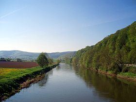
The Werra ( [ˈvɛʁa]), a river in central Germany, forms the right-source of the Weser. The Werra has its source near Eisfeld in southern Thuringia. After 293 kilometres (182 mi) the Werra joins the river Fulda in the town of Hann. Münden, forming the Weser.
Contents
Map of Werra, Germany
The Werra Valley (German: Werratal) forms a natural border between the Rhön Mountains and the Thuringian Forest. Local attractions include Eiben Forest near Dermbach, the fairytale sandstone cave at Walldorf, the deepest lake in Germany formed by land subsidence (near Bernshausen), and the "Krayenburg", the ruins of a castle.
The following towns or municipalities lie along the Werra: Hildburghausen, Meiningen, Bad Salzungen, Tiefenort, Merkers-Kieselbach, Heringen, Philippsthal, Gerstungen, Wanfried, Eschwege, Bad Sooden-Allendorf, Witzenhausen and Hann. Münden.