
Maximum boat length 740 ft 0 in (225.6 m) Locks 8 Construction began 1824 Status Open | Maximum boat beam 78 ft 0 in (23.8 m) Length 43 km Principal engineer Hiram Tibbetts | |
 | ||
Navigation authority Bridges Homer Bridge, Garden City Skyway, Bridge 11, Townline Tunnel, Main Street Tunnel, Welland Canal Bridge 5 Similar | ||
The Welland Canal is a ship canal in Ontario, Canada, connecting Lake Ontario and Lake Erie. It forms a key section of the St. Lawrence Seaway. Traversing the Niagara Peninsula from Port Weller to Port Colborne, it enables ships to ascend and descend the Niagara Escarpment and bypass Niagara Falls.
Contents
- Map of Welland Canal Ontario Canada
- St catharines museum at lock 3 of the welland canal 28 june 2011
- History
- First Welland Canal
- Second Welland Canal
- Third Welland Canal
- Fourth current Welland Canal
- Welland By Pass
- Fifth proposed but uncompleted Welland Canal
- Accidents
- Sabotage
- Shipping season
- Current canal
- List of locks and crossings
- Profile
- Old alignment prior to Welland By Pass relocation
- References
Map of Welland Canal, Ontario, Canada
Approximately 40,000,000 tonnes of cargo are carried through the canal annually by about 3,000 ocean and Great Lakes vessels. It was a major factor in the growth of the city of Toronto. The original canal and its successors allowed goods from Great Lakes ports such as Cleveland, Detroit, and Chicago, as well as heavily industrialized areas of the United States and Ontario, to be shipped to the port of Montreal or to Quebec City, where they were usually reloaded onto ocean-going vessels for international shipping.
The Welland Canal eclipsed other, narrower canals in the region, such as the Trent-Severn Waterway and, significantly, the Erie Canal (which linked the Atlantic and Lake Erie via New York City and Buffalo, New York) by providing a shorter, more direct connection to Lake Erie.
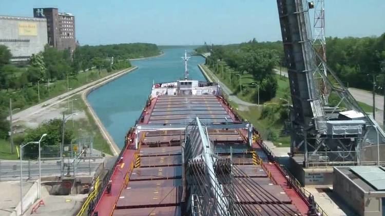
The southern, Lake Erie terminus of the canal is 99.5 metres (326 feet) higher than the northern terminus on Lake Ontario. The canal includes eight 24.4-metre-wide (80 ft) ship locks. Seven of the locks (Locks 1–7, the 'Lift' locks) are 233.5 m (766 ft) long and raise (or lower) passing ships by between 13 and 15 m (43 and 49 ft) each. The southernmost lock, (Lock 8 – the 'Guard' or 'Control' lock) is 349.9 m (1,148 ft) in length. The Garden City Skyway passes over the canal, restricting the maximum height of the masts of the ships allowed on this canal to 35.5 m (116 ft).
All other highway or railroad crossings of the Welland Canal are either movable bridges (of the vertical lift or bascule bridge types) or subterranean tunnels. The maximum permissible length of a ship in this canal is 225.5 metres (740 feet). It takes ships an average of about eleven hours to traverse the entire length of the Welland Canal.
St catharines museum at lock 3 of the welland canal 28 june 2011
History
Before the digging of the Welland Canal, shipping traffic between Lake Ontario and Lake Erie used a portage road between Chippawa, Ontario, and Queenston, Ontario, both of which are located on the Niagara River—above and below Niagara Falls, respectively.
First Welland Canal
The Welland Canal Company was incorporated by the Province of Upper Canada, in 1824, after a petition by nine "freeholders of the District of Niagara". One of the petitioners was William Hamilton Merritt, who was in part looking to provide a regular flow of water for his watermills. The construction began at Allanburg, Ontario, on November 30, at a point now marked as such on the west end of Bridge No. 11 (formerly Highway 20). This canal opened for a trial run on November 30, 1829 (exactly five years, to the day, after the ground-breaking in 1824). After a short ceremony at Lock One, in Port Dalhousie, the schooner Anne & Jane (also called "Annie & Jane" in some texts) made the first transit, upbound to Buffalo, N.Y., with Merritt as a passenger on her deck.
The first canal ran from Port Dalhousie, Ontario on Lake Ontario south along Twelve Mile Creek to St. Catharines. From there it took a winding route up the Niagara Escarpment through Merritton, Ontario to Thorold, where it continued south via Allanburg to Port Robinson, Ontario on the Welland River. Ships went east (downstream) on the Welland River to Chippawa, at the south (upper) end of the old portage road, where they made a sharp right turn into the Niagara River, upstream towards Lake Erie. Originally, the section between Allanburg and Port Robinson was planned to be carried in a subterranean tunnel. However, the sandy soil in this part of Ontario made a tunnel infeasible, and a deep open-cut canal was dug instead.
A southern extension from Port Robinson opened in 1833, with the founding of Port Colborne. This extension followed the Welland River south to Welland (known then as the settlement of Aqueduct, for the wooden aqueduct that carried the canal over the Welland River at that point), and then split to run south to Port Colborne on Lake Erie. A feeder canal ran southwest from Welland to another point on Lake Erie, just west of Rock Point Provincial Park. With the opening of the extension, the canal stretched 44 km (27 mi) between the two lakes, with 40 wooden locks. The minimum lock size was 33.5 by 6.7 m (110 by 22 ft), with a minimum canal depth of 2.4 m (7.9 ft).
Deterioration of the wood used in the 40 locks and the increasing size of ships led to demand for the Second Welland Canal, which used cut stone locks, within just a few years.
Second Welland Canal
In 1839 the government of Upper Canada approved the purchase of shares in the private canal company in response to the company's continuing financial problems in the face of the continental financial panic of 1837. The public buyout was completed in 1841, and work began to deepen the canal and to reduce the number of locks to 27, each 45.7 by 8.1 m (150 by 27 ft). By 1848, a 2.7 m (8.9 ft) deep path was completed, not only through the Welland Canal but also the rest of the way to the Atlantic Ocean via the St. Lawrence Seaway.
Competition came in 1854 with the opening of the Erie and Ontario Railway, running parallel to the original portage road. In 1859, the Welland Railway opened, parallel to the canal and with the same endpoints. But this railway was affiliated with the canal, and was actually used to help transfer cargoes from the lake ships, which were too large for the small canal locks, to the other end of the canal (The remnants of this railway are today owned by the Trillium RR). Smaller ships called "canallers" also took a part of these loads. Due to this problem, it was soon apparent that the canal would have to be enlarged again.
Third Welland Canal
In 1887, a new shorter alignment was completed between St. Catharines and Port Dalhousie. One of the most interesting features of this third Welland Canal was the Merritton Tunnel on the Grand Trunk Railway line that ran under the canal at Lock 18. Another tunnel, nearby, carried the canal over a sunken section of the St David's Road. The new route had a minimum depth of 4.3 m (14 ft) with 26 stone locks, each 82.3 m (270 ft) long by 13.7 m (45 ft) wide. Even so, the canal was still too small for many boats.
Fourth (current) Welland Canal
Construction on the current canal began in 1913 and was completed and officially opened on August 6, 1932. Dredging to the planned 25 foot depth was not completed until 1935. The route was again changed north of St. Catharines, now running directly north to Port Weller. In this configuration, there are eight locks, seven at the Niagara Escarpment and the eighth, a guard lock, at Port Colborne to adjust with the varying water depth in Lake Erie. The depth was now 7.6 m (25 ft), with locks 233.5 m (766 ft) long by 24.4 m (80 ft) wide. This canal is officially known now as the Welland Ship Canal. The Welland Canal's first "hands-free" vacuum mooring was tested in Lock 7 prior to 2014. Installation of the updated systems for Locks 1 through 7 will be completed in 2017.
Welland By-Pass
In the 1950s, with the building of the present St. Lawrence Seaway, a standard depth of 8.2 m (27 ft) was adopted. The 13.4-kilometre (8.3 mi) long Welland By-Pass, built between 1967 and 1972, opened for the 1973 shipping season, providing a new and shorter alignment between Port Robinson and Port Colborne and by-passing downtown Welland. All three crossings of the new alignment—one an aqueduct for the Welland River—were built as tunnels. Around the same time, the Thorold Tunnel was built at Thorold and several bridges were removed.
Fifth (proposed but uncompleted) Welland Canal
These projects were to be tied into a proposed new canal, titled the Fifth Welland Canal, which was planned to by-pass most of the existing canal to the east and to cross the Niagara Escarpment in one large 'superlock'. While land for the project was expropriated and the design finalized, the project never got past the initial construction stages and has since been shelved.
The present (4th) canal is scheduled to be replaced by 2030, almost exactly 100 years after it first opened, and 200 years since the first full shipping season, in 1830, of the original canal.
Accidents
On June 20, 1912, the government survey steamer La Canadienne lost control due to mechanical problems in the engine room and smashed into the upstream gates of Lock No. 22 of the 3rd Welland Canal, forcing them open by six inches. The resulting surge of water flooded downstream, cresting the upstream gates of Lock No. 21 where five boys were fishing. One boy ran to safety and one of the boys, David Boucke, was saved by a government surveyor Hugh McGuire. But the remaining three, Willie Wallace Tifney (age 5), Willie Tacke (age 5) and Leonard Bretwick (age 4) were knocked into the water, drowning in the surge.
On August 25, 1974, the northbound ore-carrier Steelton struck Bridge 12 in Port Robinson. The bridge was rising and the impact knocked the bridge over, destroying it. No one was killed. The bridge master, Albert Beaver, and a watchman on the ship suffered minor injuries. The bridge has not been replaced and the inhabitants of Port Robinson have been served by a ferry for many years. The Welland Public Library archive has images of the aftermath.
On August 11, 2001, the lake freighter Windoc collided with Bridge 11 in Allanburg, closing vessel traffic on the Welland Canal for two days. The accident destroyed the ship's wheelhouse and funnel (chimney), ignited a large fire on board, and caused minor damage to the vertical lift bridge. The accident and portions of its aftermath were captured on amateur video. The vessel was a total loss, but there were no reported injuries, and no pollution to the waterway. The damage to the bridge was focused on the centre of the vertical-lift span. It was repaired over a number of weeks and reopened to vehicular traffic on November 16, 2001. The Marine Investigation Report concluded, "it is likely that the [vertical lift bridge] operator's performance was impaired while the bridge span was lowered onto the Windoc."
At around noon on Wednesday September 30, 2015, the Lena J cargo ship collided with Bridge 19 in Port Colborne, closing the bridge to all vehicle and pedestrian traffic until an assessment could be made on the condition of the bridge. The vessel had sustained damage to its bridge, but was still able to continue on its voyage to Burns Harbour, Indiana. Pictures of the damage sustained to the vessel and Bridge 19 were captured. On Friday October 1, 2015, Chris Lee, an acting direct engineer for the City of Port Colborne, said that the St. Lawrence Seaway Management Corporation (SLSMC) will likely close the bridge to all vehicle traffic until the end of the year. However, pedestrians will be able to cross the bridge, and emergency services will be able to cross the bridge on a limited basis. On Tuesday October 6, 2015, the City of Port Colborne released a media statement, which stated that Bridge 19, "will remain closed to vehicular traffic until after the close of the shipping season in December. Repairs will begin in early January." Detour routes have been planned and mapped by the City of Port Colborne and the City of Welland in order to ease the flow of traffic over Bridge 19A.
Sabotage
The Welland Canal has been the focus of plots on a number of occasions throughout its existence. However, only two have ever been carried out. The earliest and potentially most devastating attack occurred on September 9, 1841 at Lock No. 37 (Allanburg) of the First Welland Canal (43.07796°N 79.20991°W / 43.07796; -79.20991), [approximately 180 m north of today's Allanburg bridge] when an explosive charge destroyed one of the lock gates. However, a catastrophic flood was prevented when a guard gate located upstream of the lock closed into place preventing the upstream waters from careening down the route of the Canal and causing further damage and possible injury or loss of life. It was suspected that Benjamin Lett was responsible for the explosion.
On April 21, 1900 about 6:30 in the evening, a dynamite charge was set off against the hinges of Lock No. 24 of the Third Welland Canal (just to the east of Lock No. 7 of today's canal (43.122976°N 79.192372°W / 43.122976; -79.192372)), doing minor damage. This time, the saboteurs were caught in nearby Thorold. John Walsh, John Nolan and the ringleader "Dynamite" Luke Dillon (a member of Clan-na-Gael) were tried at the Welland Courthouse and found guilty, receiving life sentences at Kingston Penitentiary. The "star witness" at the trial was a 16-year-old Thorold girl named Euphemia Constable, who caught a good look at the bombers before being knocked unconscious by the blast. While waiting to testify, the girl received death threats, but, they turned out to be a hoax. As for the prisoners, Nolan lost his sanity while incarcerated, John Walsh was eventually released while Luke Dillon remained in custody until July 12, 1914
The First World War brought with it plots against the canal and the most notable of them came to be known as "The Von Papen Plot". In April 1916, a United States federal grand jury issued an indictment against Franz von Papen, Captain Hans Tauscher, Captain Karl Boy-Ed, Constantine Covani and Franz von Rintelen on charges of a plot to blow up the Welland Canal. However, Papen was at the time safely on German soil, having been expelled from the US several months previously for alleged earlier acts of espionage and attempted sabotage.
Von Papen remained under indictment on these charges until he became Chancellor of Germany in 1932, at which time the charges were dropped.
Shipping season
The Welland Canal closes in winter (January–March) when ice or weather conditions become a hazard to navigation. The shipping season reopens in spring when the waters are once again safe. In 2007, the season opened on the earliest date ever, March 20, just hours ahead of the vernal equinox.
Current canal
List of locks and crossings
Locks and crossings are numbered from north to south.
Profile
The following illustration depicts the profile of the Welland Canal. The horizontal axis is the length of the canal. The vertical axis is the elevation of the canal segments above mean sea level.
Old alignment prior to Welland By-Pass relocation
† If assigned by the St. Lawrence Seaway Authority. The original bridges across the fourth canal were numbered in order. Numbering was not changed as bridges were removed.