Type Lake Primary outflows Twelve Mile Creek Max. width 1.0 kilometre (0.6 mi) Length 5 km Outflow location Twelve Mile Creek Part of Great Lakes Basin | Primary inflows Basin countries Canada Surface elevation 170 m Province Ontario Inflow source Welland Canal | |
 | ||
Max. length 5.0 kilometres (3.1 mi) Similar Mel Swart Lake Gibson C, Welland Canal, Decew Falls, Short Hills Provincial Park, DeCou House | ||
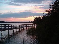
Lake Gibson is a lake near Thorold in the Regional Municipality of Niagara, Ontario, Canada. The lake is not natural, but rather was created as a reservoir for hydroelectric power generation at the Ontario Power Generation Decew Falls 1 and Decew Falls 2 generating stations. The lake was created by flooding the shallow valley of Beaverdams Creek. Lake Moodie is located to the northwest of Lake Gibson and is a smaller segment of the overall Lake Gibson system. Almost all of the water supply to these lakes comes from Lake Erie via the Welland Canal. The lakes suck part of the Twelve Mile Creek watershed.
Map of Lake Gibson, Thorold, ON, Canada
Highway 406 crosses over the lake. At the west end of the lake is Morningstar Mill consisting of a working gristmill dating from 1872, plus a reconstructed sawmill. A short distance east of this can be found the ruins of DeCou House, the destination of Laura Secord's famous journey during the War of 1812.
Lake Gibson is part of St. Catharines' drinking water supply. Consequently, no boating is permitted.
