
- location Apopka, Florida Length 25 km | - elevation 70 ft (21 m) | |
 | ||
- right Sweetwater Creek, Little Wekiva River Sources Wekiwa Springs State Park, Rock Springs Run State Reserve | ||
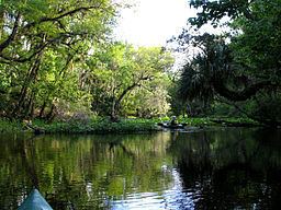
Canoeing rock springs run to wekiva island on the wekiva river
The Wekiva River (sometimes spelled Wekiwa, a Creek word meaning "spring of water") is a 16.0-mile-long (25.7 km) river in Central Florida, north of Orlando in the United States. It originates in Apopka and joins the St. Johns River, the longest river in the state, in DeBary. The Wekiva River system includes the main stem joined by three main tributaries - Rock Springs Run, Blackwater Creek, and the Little Wekiva River - and about 30 contributing groundwater springs. It is designated as a Florida State Canoe Trail, an Outstanding Florida Water, and an Aquatic Preserve by the Florida Department of Environmental Protection. The Wekiva River system is also one of the two rivers in Florida federally designated as a National Wild and Scenic River for its scenery, recreation, geology, and diverse habitats.
Contents
- Canoeing rock springs run to wekiva island on the wekiva river
- Map of Wekiva River Florida USA
- Canoe camping on the wekiva river
- OverviewEdit
- OriginEdit
- Wekiwa SpringsEdit
- Rock Springs RunEdit
- Little Wekiva RiverEdit
- Wekiva River Buffer Conservation AreaEdit
- Black Water CreekEdit
- References
Map of Wekiva River, Florida, USA
Canoe camping on the wekiva river
OverviewEdit
The Wekiva River system is located in three counties - Orange, Seminole, and then Lake - with a total drainage basin of 351.113 km2 (135.565 sq mi). The river nearly follows the boundary between Orange and Seminole Counties. After Orange County, the river separates Lake County and Seminole County.
OriginEdit
According to the St. Johns River Water Management District and the Geographic Names Information System, the Wekiva River originates from Wekiwa Springs, and about 3⁄4 mile (1.2 km) from the spring, Wekiva is joined by the Rock Springs Run.
The Florida Department of Environmental Protection defines the portion of the river from Wekiwa Springs to the confluence with Rock Springs Run as the Wekiwa Springs Run. The Wekiva River then starts from the confluence of the two spring runs and joins the St. Johns River after 15.3 miles (24.6 km).
Wekiwa SpringsEdit
The headwater of the Wekiva River is the Wekiwa Springs, a second-magnitude spring located within the Wekiwa Springs State Park in Apopka. The spring has a mean discharge of 66.5 cu ft/s (1.88 m3/s) or 5,745,600 cubic feet (42,980,000 US gal) per day emanating from two vents, the largest of which is 35 by 5 ft (10.7 by 1.5 m) located 15 ft (4.6 m) under the water. A weir located about 270 ft (82 m) from the springs forms a 200-by-100-foot (61 by 30 m)-wide pool for swimming. At 170 ft (52 m) from the weir, the river widens into a trapezoidal pool about 430 ft (130 m) at its widest. The clear, bluish-green water narrows into a 60-foot (18 m)-wide run as it flows northeastward.
Rock Springs RunEdit
After only about 3⁄4 mile (1.2 km) from the headwater, the Wekiva River is joined by Rock Springs Run, a spring-fed stream that originates from Rock Springs, a second-magnitude spring located about 4 miles (6.4 km) northwest of Wekiwa Springs. Rock Springs is situated inside Kelly Park, an Orange County park in Apopka. After leaving the county park, the stream enters the Wekiwa Springs State Park, meandering for a total length of 9.2 miles (14.8 km) before joining Wekiva River. After the confluence, the area left of the Wekiva River is protected by Rock Springs Run State Reserve, another Florida state park.
Little Wekiva RiverEdit
The Wekiva is joined by the Little Wekiva River about 1.2 mi (1.9 km) from the headwater. The 2-mile (3.2 km)-long stream is merged by the outflow of Miami Springs, a third- magnitude spring, about 800 ft (240 m) before the confluence with Wekiva River.
Wekiva River Buffer Conservation AreaEdit
Beyond the creek, the eastern side of the river is protected by the Wekiva River Buffer Conservation Area, a 2,570 acres (1,040 ha) protected seasonal wetlands of lush floodplain forest of hardwoods, ferns, and sabal palms along the Wekiva and Little Wekiva Rivers. Protecting the natural condition of the area helps preserve the water quality of both rivers.
Little Wekiva RiverEdit
The Little Wekiva River merges with the Wekiva River about 4.7 mi (7.6 km) from the source. The 15-mile (24 km)-long Little Wekiva River is the only tributary influenced by the areas north and west of urban Orlando. The St. Johns River Water Management District has worked with the Florida Department of Environmental Protection, the Florida Department of Transportation, the city of Altamonte Springs, Seminole and Orange counties, environmental interest groups and basin residents to find solutions in rehabilitating and protecting the Little Wekiva to minimize its negative impact in the water quality of the Wekiva River. In Longwood before the Little Wekiva enters the Wekiva River Buffer Conservation Area, several second- and third-magnitude]] springs, including the Sanlando Springs, replenish the Little Wekiva with fresh underground water.
Black Water CreekEdit
The last main tributary of the Wekiva River is the 19-mile (31 km) Black Water Creek, which joins the Wekiva about 2 miles (3.2 km) before the Wekiva joins the St. Johns River.