
Existed: 1964 – present Length 94.3 km | Constructed 1964 | |
 | ||
Counties | ||
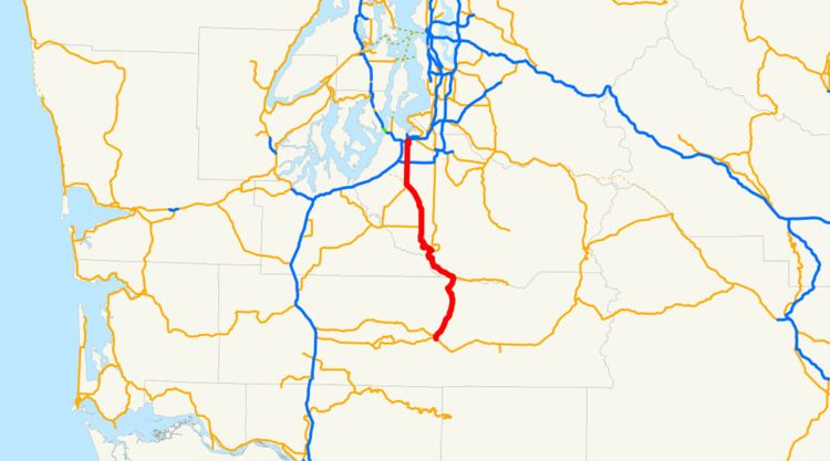
State Route 7 (SR 7) is a state highway in Lewis and Pierce counties, located in the U.S. state of Washington. The 58.60-mile (94.31 km) long roadway begins at U.S. Route 12 (US 12) in Morton and continues north to intersect several other state highways to Tacoma, where it ends at an interchange with Interstate 5 (I-5) and I-705. The road has several names, such as Second Street in Morton, the Mountain Highway in rural areas, Pacific Avenue in Spanaway, Parkland and Tacoma and 38th Street in Tacoma. Near the end of the highway there is a short freeway that has been proposed to be extended south parallel to an already existing railroad, owned by Tacoma Rail, which serves as the median of the short freeway.
Contents
Map of WA-7, Washington, USA
The earliest road to use the current route of SR 7 first appeared in a 1900 map of the Tacoma area and has been part of the state highway system since 1909, when the Alder-Kosmos Road was added to the system as State Road 18. State Road 18 became part of two branches of State Road 5 in 1923 and later branches of Primary State Highway 5. During the 1964 highway renumbering, the branches became SR 7. In 2002, an auxiliary route that bypasses Tacoma, SR 704, was established and construction started in 2008 to connect I-5, Fort Lewis, McChord Air Force Base and SR 7.
Route description
State Route 7 (SR 7) begins at an intersection with U.S. Route 12 (US 12), a major east–west highway, in Morton. Traveling north as Second Street and paralleling the Morton – Tacoma (Mountain Division) route of Tacoma Rail, the street intersects Main Avenue, which continues west out of the city as SR 508. After leaving Morton, the highway becomes the Mountain Highway and passes through a heavily forested canyon near Mount Rainier and parallel to the Tilton River and Roundrop Creek. Bridging the Nisqually River, the highway leaves Lewis County and enters Pierce County. In Elbe, the roadway intersects SR 706, which goes east to Mount Rainier National Park. Following the Nisqually River, which has become Alder Lake, and Tacoma Rail line, SR 161 branches off towards Eatonville and SR 702 travels west from the plains to McKenna.
Passing Elk Plain and suburban areas, the highway enters Spanaway near the Fort Lewis boundary where SR 7 intersects SR 507, which continues southwest to Chehalis. The Mountain Highway becomes Pacific Avenue and enters Parkland. Shortly after 112th Street, the roadway has a partial cloverleaf interchange with SR 512, which uses 108th Street South as two ramps. Leaving Parkland and entering Tacoma, Pacific Avenue turns east as 38th Street and then has another partial cloverleaf interchange with a short freeway and the proposed route of SR 7, which is used by the roadway. The freeway was the busiest segment of the highway in 2007, with an estimated daily average of 27,000 motorists. The median of the freeway is the Tacoma Rail route and at the northern terminus is an interchange with Interstate 5 (I-5). SR 7 ends at the interchange, located near the Tacoma Dome, but continues north parallel to the railroad to a single-point urban interchange with SR 509 as I-705.
History
A 1900 map of the Tacoma area showed a roadway extending north from Spanaway to Tacoma that would later become SR 7. In 1909, the Alder-Kosmos Road, numbered State Road 18, was added to the state highway system and ran from Kosmos north through Morton and Elbe to Alder. The National Park Highway was created in 1913 and extended from the Pacific Ocean to Tacoma and south to Elbe, where it turned east into Mount Rainier National Park. Both highways were replaced by two branches of State Road 5 in 1923, which traveled from Tacoma to Mount Rainier and Elbe to Chehalis. State Road 5 became Primary State Highway 5 (PSH 5) during the creation of the Primary state highways in 1937 and the Tacoma–Mount Rainier branch remained the same, but the Elbe–Chehalis branch was shortened to Kosmos.
The Chicago, Milwaukee, St. Paul and Pacific Railroad started to parallel the route by 1951 between Tacoma and Morton. During the 1964 highway renumbering the two branches of PSH 5 became SR 7. Between 1968 and 2008, the Chicago, Milwaukee, St. Paul and Pacific Railroad transferred the railroad parallel to the highway to Tacoma Rail. In 2002, a new auxiliary route of SR 7, SR 704 was established to provide a bypass of Tacoma to provide direct connections between Interstate 5 (I-5), Fort Lewis, McChord Air Force Base and SR 7 in Spanaway. On July 30, 2008, the Washington State Department of Transportation (WSDOT) had a groundbreaking ceremony to start construction of SR 704, which has been predicted to be finished after 2017. The segment of the highway between SR 507 in Spanaway to SR 512 in Parkland had a very high accident rate, so WSDOT added safety improvements to the roadway in 2007. Between Morton and Spanaway, WSDOT is currently (as of 2009) developing a route development plan to improve the roadway. The project is divided into three phases, the first phase was completed in 2006 and focused between Morton and Elbe and the second phase will be focused between Elbe and SR 702 while the third will focus between SR 702 to Spanaway.