
Existed: 1969 – present Constructed 1969 North end BC 13 near Langley, BC | Counties: Whatcom Length 24.4 km | |
 | ||
County | ||
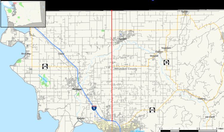
State Route 539 (SR 539), named the Meridian Street in Bellingham, Guide Meridian Road elsewhere, and commonly known as The Guide, is a state highway in Washington, United States. It runs for 15.16 miles from Bellingham in the south to the Canada–US border at Lynden-Langley in the north. The road is so named because it follows the Guide Meridian between R2E and R3E, 12 miles east of the Willamette Meridian.
Contents
Map of WA-539, Washington, USA
Route description
SR 539 begins at Exit 256 of Interstate 5 just south of the Bellis Fair Mall, approximately four miles north of downtown Bellingham. From there it proceeds due north to the Canada–US border between Lynden and the Township of Langley, British Columbia.
Once past the Bellis Fair Mall immediately north of the I-5 interchange, SR 539 continues through the shopping centers of the northern outskirts of Bellingham; Whatcom Community College and the Cordata Business Park are also nearby.
North of Bellingham, it passes through the small town of Laurel, which contains Meridian High School. It then passes over Wiser Lake and the Nooksack River, before arriving in Lynden, home to a municipal airport. At Lynden it changes from 4 lanes to 2 as it proceeds north to the border near Aldergrove, British Columbia, Canada.
The entire route from I-5 to the border is perfectly straight north–south. It serves mostly traffic from Bellingham (and I-5) to the city of Lynden, although it also serves the Everson-Nooksack-Sumas area via State Route 544. It also provides an alternate route into Canada when the border crossings at Blaine on I-5 and State Route 543 are backed up.
History
Prior to the 1964 state highway renumbering, SR 539 was known as SSH (Secondary State Highway) 1-B. (The I-5 corridor at the time was known as Primary State Highway 1.) U.S. Route 99 came into being in 1926 with the rest of the original U.S. Highways, and was signed concurrently with PSH-1 until 1964. In 1954, SSH-1-B was designated as U.S. Route 99 Alternate. During the 1964 renumbering, the PSH-1 and SSH-1-B designations were removed. Then in 1969, U.S. 99 was decommissioned in the state of Washington, as was Alt. U.S. 99, and Alt. U.S. 99 was replaced by SR 539.
The routing of SSH-1-B/Alt. U.S. 99 presumably continued south on Meridian Street past what is now I-5, then down either Broadway or Girard Street in downtown Bellingham to connect with U.S. 99/PSH-1, which at the time ran on Holly Street, Prospect Street, and Dupont Street in downtown Bellingham.
The first road from Bellingham to Lynden was the "Plank Road" built of 10x10 inch planks laid side by side in the 1890s. One part of the road went around Wiser Lake and a part of that road is now called Old Guide Road.
Guide Meridian Road was transformed from a two-lane highway to a four-lane highway in the late 2000s. The project was completed in two phases. The first phase, carried out by IMCO General Construction of Bellingham, was from Horton Road to Ten Mile Road. Along with the wider roadway the project installed new signals at Smith, Axton and Laurel Road intersections. It also replaced both the Four Mile Creek and Ten Mile Creek Bridges with wider, safer bridges. Construction of this segment was started in June 2007 and completed in Fall 2008, at a total cost of $39.9 million, funded by the Washington State DOT.
The second phase created a four-lane highway from Ten Mile Road to Badger Road; this phase was carried out by Max J. Kuney Construction of Spokane. It also built four new roundabouts at Ten Mile Road, Pole Road, Wiser Lake Road, and River Road to further help improve safety. Bridges were widened or replaced at Wiser Lake, Fishtrap Creek, Floodway and Nooksack River. In Summer 2007 the crews moved utilities from the roadway. In Fall 2007 the DOT finished buying property, and construction began in Spring 2008. The project was completed in July 2010.
Major intersections
The entire route is in Whatcom County.