
Founded July 5, 1843 Population 554,996 (2013) | Area 1,880 km² Unemployment rate 4.3% (Apr 2015) | |
 | ||
Website www.co.washington.or.us Colleges and Universities Pacific University, Oregon College of Art and C, Pacific University Health Pr, OGI School of Science and Engi, Sumner College Destinations | ||
Bethany neighborhood washington county oregon
Washington County is one of 36 counties in the U.S. state of Oregon. As of the 2010 census, the population was 529,710, making it the state's second most populous county. The county seat and largest city is Hillsboro.
Contents
- Bethany neighborhood washington county oregon
- Map of Washington County OR USA
- Safe routes to school washington county oregon
- History
- Geography
- Waterways
- Adjacent counties
- National protected areas
- 2000 census
- 2010 census
- Government
- Politics
- Economy
- References
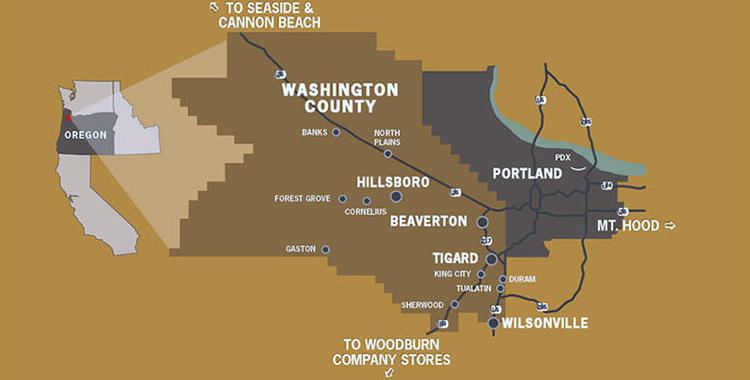
Map of Washington County, OR, USA
Washington County is part of the Portland-Vancouver-Hillsboro, OR-WA Metropolitan Statistical Area.
Cities in Washington County include Hillsboro, Beaverton, Tigard, and Forest Grove, the county's oldest city.
Originally named Twality when created in 1843, the territorial legislature renamed it for the first president of the United States, George Washington, in 1849. The original boundaries included the entire northwest corner of Oregon before sections became new counties. The Tualatin River and its drainage basin are almost entirely within the county, with the county nearly coterminous with the Tualatin Valley. It is bordered on the west and north by the Northern Oregon Coast Range, on the south by the Chehalem Mountains, and on the north and east by the Tualatin Mountains (or West Hills).
The county's major roads include small sections of Interstate 5 and Interstate 205, the Sunset Highway, Oregon Route 217, Oregon Route 47, Oregon Route 10, Oregon Route 6, and Oregon Route 8. Public transportation is primarily operated by TriMet and includes buses, the Westside Express Service commuter rail, and MAX Light Rail. Other transportation includes air travel at the Hillsboro Airport, private airfields and heliports, and heavy rail cargo on rail lines.
Safe routes to school washington county oregon
History
The Provisional Legislature of Oregon created the county as Twality District on July 5, 1843. Twality was one of the original four districts of the Provisional Government of Oregon in Oregon Country along with Clackamas, Champooick (later Marion), and Yamhill counties. Columbia, later known as Hillsboro, was selected as the county seat in 1850. Washington County obtained its present boundaries in 1854 with the creation of Columbia County to the north and Multnomah County to the east.
The construction of Canyon Road to Beaverton helped Portland to consolidate its position as the primary port of Oregon, and defeat the rival efforts of settlements such as Oregon City and Milwaukie.
In November 2004, the County and the City of Beaverton agreed to a plan where the city would annex both unincorporated residential neighborhoods as well as high-value areas of land. This would result with Cedar Hills, Garden Home, Raleigh Hills, West Slope being incorporated by 2010, and the communities of Aloha, Bethany, and Cedar Mill at some point after that.
Those plans have since been put on hold after Beaverton attempted to forcibly annex Nike, Inc.'s World Headquarters, which would have increased Nike's taxes substantially. Nike successfully lobbied the legislature for a law that would prohibit their annexation for 99 years. Since that decision, annexation plans have been halted, and Washington County started urban planning to provide city-level services to the unincorporated urban areas in the county.
On January 1, 2014, 160 acres (65 ha) of Multnomah County in the Bethany area transferred to Washington County. The area had originally been split off from Washington County when Multnomah County was created, and was transferred back to allow for development of the property.
Geography
According to the U.S. Census Bureau, the county has a total area of 726 square miles (1,880 km2), of which 724 square miles (1,880 km2) is land and 2.2 square miles (5.7 km2) (0.3%) is water. It is located approximately 20 miles (32 km) to the west of Portland. The Portland Metro Urban Growth Boundary (UGB) bisects the county. The county's highest point is South Saddle Mountain at 3,464 feet (1,056 m) above sea level in the Northern Oregon Coast Range.
Most of the county is in the Tualatin Valley, which is surrounded by the Tualatin Mountains to the east and north, the Chehalem Mountains to the south, and the Northern Oregon Coast Range to the west and north. In the valley is the only river in the county, the Tualatin River, the Tualatin Plains, and several small hills. The northern and western portions of the county are forested, while the remainder of the county includes urban areas, agricultural lands, and floodplains.
Waterways
The Tualatin River is the main river in Washington County. Henry Hagg Lake, southwest of Forest Grove, is the largest lake. The Willamette River lies to the east, the Columbia River to the northeast, and the Pacific Ocean to the west of the county.
Adjacent counties
National protected areas
2000 census
As of the census of 2000, there were 445,342 people, 169,162 households, and 114,015 families residing in the county. The population density was 615 people per square mile (238/km²). There were 178,913 housing units at an average density of 247 per square mile (95/km²). The racial makeup of the county was 82.19% White, 1.15% Black or African American, 0.65% Native American, 6.68% Asian, 0.30% Pacific Islander, 5.86% from other races, and 3.17% from two or more races. 11.17% of the population were Hispanic or Latino of any race. 17.2% were of German, 9.9% English, 8.2% Irish and 6.7% American ancestry. 81.7% spoke only English at home, while 9.6% spoke Spanish and 1.2% Vietnamese.
There were 169,162 households out of which 35.60% had children under the age of 18 living with them, 54.50% were married couples living together, 9.00% had a female householder with no husband present, and 32.60% were non-families. 24.70% of all households were made up of individuals and 6.70% had someone living alone who was 65 years of age or older. The average household size was 2.61 and the average family size was 3.14.
In the county, the population was spread out with 26.90% under the age of 18, 9.30% from 18 to 24, 34.10% from 25 to 44, 20.90% from 45 to 64, and 8.80% who were 65 years of age or older. The median age was 33 years. For every 100 females there were 99.10 males. For every 100 females age 18 and over, there were 97.00 males.
The median income for a household in the county was $52,122, and the median income for a family was $61,499. Males had a median income of $43,304 versus $31,074 for females. The per capita income for the county was $24,969. About 4.90% of families and 7.40% of the population were below the poverty line, including 8.30% of those under age 18 and 5.30% of those age 65 or over.
2010 census
As of the 2010 United States Census, there were 529,710 people, 200,934 households, and 134,323 families residing in the county. The population density was 731.4 inhabitants per square mile (282.4/km2). There were 212,450 housing units at an average density of 293.3 per square mile (113.2/km2). The racial makeup of the county was 76.6% white, 8.6% Asian, 1.8% black or African American, 0.7% American Indian, 0.5% Pacific islander, 7.5% from other races, and 4.3% from two or more races. Those of Hispanic or Latino origin made up 15.7% of the population. In terms of ancestry, 20.8% were German, 12.4% were English, 12.1% were Irish, and 3.2% were American.
Of the 200,934 households, 36.0% had children under the age of 18 living with them, 52.2% were married couples living together, 10.1% had a female householder with no husband present, 33.2% were non-families, and 25.1% of all households were made up of individuals. The average household size was 2.60 and the average family size was 3.14. The median age was 35.3 years.
The median income for a household in the county was $62,574 and the median income for a family was $76,778. Males had a median income of $54,417 versus $40,254 for females. The per capita income for the county was $30,522. About 6.7% of families and 9.5% of the population were below the poverty line, including 12.5% of those under age 18 and 6.7% of those age 65 or over.
Government
The county is governed by an elected board of five commissioners. The county is divided into four commissioner districts. One commissioner sits for each district, and the fifth commissioner is "at large" and is the Chair of the board.
Politics
Washington County generally leans Democratic but can be closely divided. In 2008, Barack Obama won with 59.8% of the popular vote (141,544 total votes) to Republican John McCain's with 37.7% (89,185). For the Senatorial race that year, it was much closer with Democrat Jeff Merkley winning 48.8% of the vote (111,367); Republican Gordon H. Smith won 46.5% of the vote (106,114).
Economy
Washington County is centered on a fertile plain that attracted farmers before the first wagon trains. In 1997, orchards covered 8,403 acres (34 km²) of the county's lands and 1,163 acres (4.7 km²) were devoted to vineyards. Agriculture is still a major industry in Washington County, as are lumber, manufacturing, and food processing. (The county is home to Roloff Farms, featured in the TV show Little People, Big World.)
The development of a large electronics industry during the 1980s and 1990s is the dominating factor of the county economy. California-based Intel, Oregon's largest private for-profit employer, has its largest concentration of employees in the county, mainly in Hillsboro. Other technology companies include Electro Scientific Industries, Lattice Semiconductor, FEI Company, Merix, TriQuint Semiconductor, Tektronix, SolarWorld, Planar Systems, and EPSON.
Nike, one of two Fortune 500 corporations based in Oregon, has its headquarters in Washington County. Until it was acquired by IBM, Sequent Computer Systems was headquartered right next door to Nike. Other companies with headquarters in Washington County include optical instruments manufacturer Leupold & Stevens, Columbia Sportswear, and Reser's Fine Foods.