
Length 12.1 km | ||
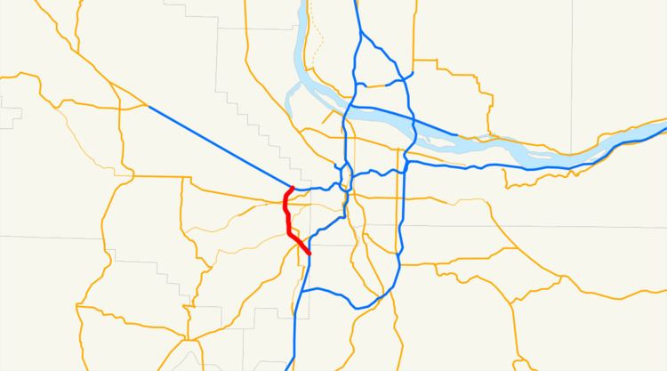 | ||
Oregon Route 217 is an Oregon state highway which serves the western suburbs of Portland. OR 217 is a limited-access freeway which connects U.S. Route 26 with Interstate 5.
Contents
Map of OR-217, Oregon, USA
OR 217 consists of the Beaverton-Tigard Highway No. 144 (see Oregon highways and routes).
Route description
For most of its length, OR 217 is a freeway with two travel lanes in each direction, with a third weave lane for exiting and merging, with the exception of its two termini.
The northern terminus of OR 217 is an interchange with US 26, at that point a freeway known as the Sunset Highway. OR 217 proceeds south, through the suburbs of Beaverton and Tigard. The southern terminus of OR 217 is an interchange with I-5 at exit 292 (292A for northbound traffic)
Commuters heading towards either terminus will find themselves on surface streets if they fail to exit. Indeed, southbound travelers wishing to get onto northbound I-5 have to turn left at a traffic signal; southbound travelers of I-5 wishing to become northbound travelers of OR 217 must turn right at a traffic signal at the end of the off-ramp. Access from I-5 North to OR 217 North used to be routed through a 270-degree ramp. A major rebuild of the I-5/OR 217 junction in 2001 resulted in the construction of a flyover ramp, relieving some of the severe congestion associated with the old design (compare before and after satellite photos). This reconstruction also left room for future freeway-to-freeway connections in other directions.
Traffic on OR 217 is frequently heavy, especially during rush hour. The freeway has several major design issues, one of which is the many closely spaced on and off-ramps (sometimes less than 1/4 mile) that result in conflict between entering and exiting traffic. The Oregon Department of Transportation (ODOT) is investigating a major overhaul of this route.
Before the freeway was completed in the late 1960s to the 1970s, OR 217 ran along surface streets. It originally started at the junction of OR 8 and Hall Blvd. in Beaverton, continuing along Hall Boulevard through Beaverton, Progress, Metzger, and Tigard for 7 miles (11 km) until it reached Durham Road. There, it took a left onto Durham Road, following it for about 0.8 miles (1.3 km) until the intersection with Boones Ferry Road. It remained on Boones Ferry Road through Durham, Tualatin, and Wilsonville for about 8 miles (13 km), crossing the Willamette River on a ferry and continuing south for another 5 miles (8.0 km) until finally ending at U.S. Route 99E at Aurora, for a grand total of about 20 miles (32 km) or so. The southern terminus was scaled back to Wilsonville (current I-5 exit 286) with the completion of I-5 to Portland. This older highway, called the Beaverton-Aurora Highway, was kept in the state highway system as the Beaverton-Tualatin Highway No. 141, and was recently given the route designation OR 141.
Exit list
The entire route is in Washington County.