
Founded 1846 Website www.warrencountyia.org Population 47,336 (2013) Congressional district 3rd University Simpson College | Area 1,484 km² Unemployment rate 3.2% (Apr 2015) | |
 | ||
Cities Indianola, Martensdale, Lacona, Ackworth, New Virginia, St. Marys, Milo, Hartford, Spring Hill, Sandyville, Cumming | ||
Warren County is a county located in the U.S. state of Iowa. As of the 2010 census, the population was 46,225. The county seat is Indianola.
Contents
- Map of Warren County IA USA
- Peck cemetery lincoln township warren county iowa
- History
- Geography
- Adjacent counties
- 2010 census
- 2000 census
- Unincorporated communities
- Townships
- Population ranking
- References
Map of Warren County, IA, USA
Warren County is included in the Des Moines–West Des Moines, IA Metropolitan Statistical Area.
Peck cemetery lincoln township warren county iowa
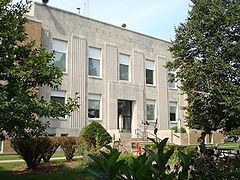
History
Warren County was formed in 1846. It was named for General Joseph Warren, a hero in the American Revolutionary War. The present Warren County Court House was opened in 1939.
Geography
According to the U.S. Census Bureau, the county has a total area of 573 square miles (1,480 km2), of which 570 square miles (1,500 km2) is land and 3.5 square miles (9.1 km2) (0.6%) is water.
Adjacent counties
2010 census
The 2010 census recorded a population of 46,225 in the county, with a population density of 80.8638/sq mi (31.2217/km2). There were 18,371 housing units, of which 17,262 were occupied.
2000 census
As of the census of 2000, there were 40,671 people, 14,708 households, and 11,207 families residing in the county. The population density was 71 people per square mile (27/km²). There were 15,289 housing units at an average density of 27 per square mile (10/km²). The racial makeup of the county was 98.08% White, 0.27% Black or African American, 0.17% Native American, 0.38% Asian, 0.04% Pacific Islander, 0.29% from other races, and 0.76% from two or more races. 1.08% of the population were Hispanic or Latino of any race.
There were 14,708 households out of which 37.80% had children under the age of 18 living with them, 64.50% were married couples living together, 8.80% had a female householder with no husband present, and 23.80% were non-families. 19.90% of all households were made up of individuals and 8.70% had someone living alone who was 65 years of age or older. The average household size was 2.65 and the average family size was 3.05.
In the county, the population was spread out with 27.00% under the age of 18, 9.70% from 18 to 24, 28.20% from 25 to 44, 23.20% from 45 to 64, and 11.80% who were 65 years of age or older. The median age was 36 years. For every 100 females there were 94.60 males. For every 100 females age 18 and over, there were 91.80 males.
The median income for a household in the county was $50,349, and the median income for a family was $56,344. Males had a median income of $36,983 versus $26,768 for females. The per capita income for the county was $20,558. About 3.70% of families and 5.10% of the population were below the poverty line, including 6.40% of those under age 18 and 5.20% of those age 65 or over.
Unincorporated communities
Townships
Warren County has sixteen townships:
Population ranking
The population ranking of the following table is based on the 2010 census of Warren County.
† county seat