
Founded 1846 Area 1,456 km² | Website madisoncoia.us Population 15,448 (2013) Unemployment rate 3.6% (Apr 2015) | |
 | ||
Points of interest John Wayne Birthplac, Winterset City Park, Pammel State Park, Winterset Parks & Recreation, Clark Tower | ||
Madison County is a county located in the U.S. state of Iowa. As of the 2010 census, the population was 15,679. The county seat is Winterset.
Contents
- Map of Madison County IA USA
- History
- Geography
- Major highways
- Adjacent counties
- 2010 census
- 2000 census
- Covered bridges
- Tunnel
- Unincorporated communities
- Population ranking
- References
Map of Madison County, IA, USA
Madison County is included in the Des Moines–West Des Moines, IA Metropolitan Statistical Area.
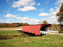
Madison County is famous for being the county where John Wayne was born, and for a number of covered bridges. These bridges were featured in the 1992 book, 1995 movie, and 2014 musical The Bridges of Madison County.
History
Madison County was formed on January 13, 1846. It has been self-governed since 1849. It was named after James Madison (1751–1836), the fourth President of the United States (between 1809 and 1817). Hiram Hurst, a suspected murderer, arsonist and hog thief was the first white settler in Madison County, having come from Missouri about April 15, 1846.
Geography
According to the U.S. Census Bureau, the county has a total area of 562 square miles (1,460 km2), of which 561 square miles (1,450 km2) is land and 1.2 square miles (3.1 km2) (0.2%) is water.
Major highways
Adjacent counties
2010 census
The 2010 census recorded a population of 15,679 in the county, with a population density of 27.9413/sq mi (10.7882/km2). There were 6,554 housing units, of which 6,025 were occupied.
2000 census
As of the census of 2000, there were 14,019 people, 5,326 households, and 3,925 families residing in the county. The population density was 25 people per square mile (10/km²). There were 5,661 housing units at an average density of 10 per square mile (4/km²). The racial makeup of the county was 98.57% White, 0.09% Black or African American, 0.27% Native American, 0.18% Asian, 0.02% Pacific Islander, 0.19% from other races, and 0.68% from two or more races. 0.75% of the population were Hispanic or Latino of any race. Madison County was mentioned as an "Extreme Whitopia" in Rich Benjamin's book, Searching for Whitopia.
There were 5,326 households out of which 34.80% had children under the age of 18 living with them, 63.90% were married couples living together, 7.00% had a female householder with no husband present, and 26.30% were non-families. 22.70% of all households were made up of individuals and 11.70% had someone living alone who was 65 years of age or older. The average household size was 2.58 and the average family size was 3.04.
In the county, the population was spread out with 27.10% under the age of 18, 6.90% from 18 to 24, 27.40% from 25 to 44, 23.40% from 45 to 64, and 15.20% who were 65 years of age or older. The median age was 38 years. For every 100 females there were 97.40 males. For every 100 females age 18 and over, there were 93.10 males.
The median income for a household in the county was $41,845, and the median income for a family was $48,289. Males had a median income of $31,126 versus $24,095 for females. The per capita income for the county was $19,357. About 4.60% of families and 6.70% of the population were below the poverty line, including 6.60% of those under age 18 and 10.40% of those age 65 or over.
Covered bridges
There are only six extant covered bridges in Madison County:
The bridges were designed primarily by Eli Cox. Eli and his sons built several of the bridges including Imes and Cutler-Donahoe. Some of the bridges were built by Benton Jones.
Tunnel
Madison county is home to the only highway tunnel in Iowa, Harmon Tunnel, through the neck of an incised meander of the Middle River in Pammel Park.
Unincorporated communities
Population ranking
The population ranking of the following table is based on the 2010 census of Madison County.
† county seat