
Local time Saturday 2:23 AM | ||
 | ||
Weather 9°C, Wind S at 14 km/h, 34% Humidity | ||
Walpi, (Navajo: Deezʼáahjįʼ), is a Hopi village established around 900 CE. It is located above Arizona State Route 264, east of the Grand Canyon in Navajo County, northern Arizona.
Contents
Map of Walpi, AZ 86042, USA
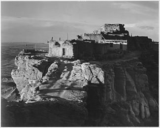
Walpi is an ancient stone pueblo complex located on the First Mesa (of three), 300 feet (91 m) above the canyon floor, on the Hopi Reservation. The villages of Sichomovi and Tewa (Hano) are also on First Mesa, both established after the Pueblo Revolt of 1680 against the Spanish missions.
History
Walpi, of the Hopi people, is one of the older continuously inhabited villages in the United States, continuously inhabited for more than 1100 years since around 900 CE. It is an example of traditional Hopi stone architecture, used for their historic pueblos built at defensive locations on the mesa tops.
The stone pueblo subtly rising from the stone mesa was well documented by photographs in the latter 19th century, by Edward S. Curtis, John K. Hillers, and others. Ansel Adams continued in the 20th century, along with increasing tourists' 'snapshots' via Fred Harvey bus tours and their own automobiles up from Route 66.
Present day
The First Mesa Tourism Program describes the village of Walpi as "a living village where the homes are passed down through matrilineal clan lineage."
About half a dozen in number live in the ancient stone dwellings, without running water or electricity, in the traditional manner.
Walpi is accessible to visitors by guided tours, given by the First Mesa Consolidated Villages’ Tourism Program.