
Postcode(s) 2618 Postal code 2618 Federal division Division of Hume | Population 644 (2011 census) State electorate(s) Burrinjuck | |
 | ||
Location 19 km (12 mi) NW of Canberra295 km (183 mi) SW of Sydney47 km (29 mi) S of Yass, New South Wales | ||
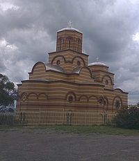
Wallaroo is a rural locality in New South Wales close to the Australian Capital Territory. It lies north of the Australian Capital Territory border, north west of Hall, west of the Barton Highway, and east of the Murrumbidgee River. The post code is 2618. The median house price was $888,750 in 2009, based on six sales. The cadastral unit in the area is known as Wallaroo Parish. Between 1981-1990, the Serbian Orthodox Church constructed the St. Sava monastery at Wallaroo. Established as the headquarters of the Diocese of Australia and New Zealand, the church is modeled on the Kalenić monastery in Serbia, built in the 15th century.
Contents
Map of Wallaroo NSW 2618, Australia
Namesakes
There is also a Wallaroo Parish, near Dubbo in Lincoln County, New South Wales that is not near this locality (approximately 350 kilometres away).
There is also a Wallaroo in South Australia.