
Established 1838 Founded 1838 | Postcode(s) 5081 Area 134 ha Postal code 5081 | |
 | ||
Population 2,370 (2006 census); 2,313 (2001 Census) | ||
Walkerville terrace walkerville south australia 12 11 12
Walkerville is a suburb of Adelaide, South Australia. It lies just north east of the city centre, about 4 kilometres from the Adelaide GPO. Walkerville is one of South Australia's most affluent suburbs and in 2012 it was South Australia's second "top earning suburb."
Contents
- Walkerville terrace walkerville south australia 12 11 12
- Map of Walkerville SA 5081 Australia
- History
- Governance
- Historical buildings
- References
Map of Walkerville SA 5081, Australia
History
Walkerville was named after Captain John Walker R. N. who took up land in the district in 1838, two years after the first colonists arrived in South Australia. The area was attractive to early settlers and within a few years, the settlement had become a village. During the 1840s, Walker fell victim to over-speculation in land value and a statewide financial depression. He was imprisoned briefly for debt and in 1849 he left the colony to take up a government position in Hobart. His connection with the state, although brief, is remembered in the naming of the suburb. Walkerville Post Office opened on 1 January 1896 and Walkerville District Council was established in 1855 after a petition by local residents proclaimed a desire to break away from the larger Yatala District Council (proclaimed in 1853). Initially, only the suburbs of Walkerville and Gilberton seceded from Yatala but within a few months, Medindie and (what was) Walkerville North were included also. The district boundaries remained unchanged until 1970 when Vale Park was added.
Early council meetings were held in a room at the local pub, the Sussex Arms, until 1893 when the foundation stone for the present Town Hall was laid on Walkerville Terrace. In 1908, the Institute Library was founded in a small room opposite the municipal offices. In 1963, it became incorporated as a Public Library and in 1970 it moved into dedicated quarters next door where the old Walkerville Police Station had been.
There are two primary schools in Walkerville: St Andrew's School was founded in 1850 and Walkerville Primary School was founded in 1884.
Governance
Today, the Town of Walkerville is Walkerville's local government area, named after Walkerville itself. Being an inner north eastern suburb, Walkerville lies in the state electoral district of Adelaide as well as the federal electoral division of Adelaide.
The residents of the Corporation of the Town of Walkerville are represented by a mayor and eight councillors.
Historical buildings
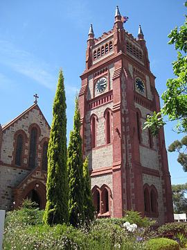
Walkerville is home to many historical buildings. One such building, which features on Walkerville’s Seal of Office, is St Andrew’s Church. Construction for the church began in 1847 and was completed the following year. The church was initially without a permanent reverend, the congregation relying on the services of the St Peter's College headmaster, Reverend T. P. Wilson. In 1850 the church’s first resident reverend, Reverend John Watson, arrived. The original building was only 12 metres long and was subject to much renovation in the second half of the 19th century. In 1857 a sanctuary and transepts were added, and in 1886 the original building was replaced by a longer nave. A tower was also added, with clock donated by the widow of Henry Kent Hughes, and whose bells can still be heard among the streets of Walkerville to this day.